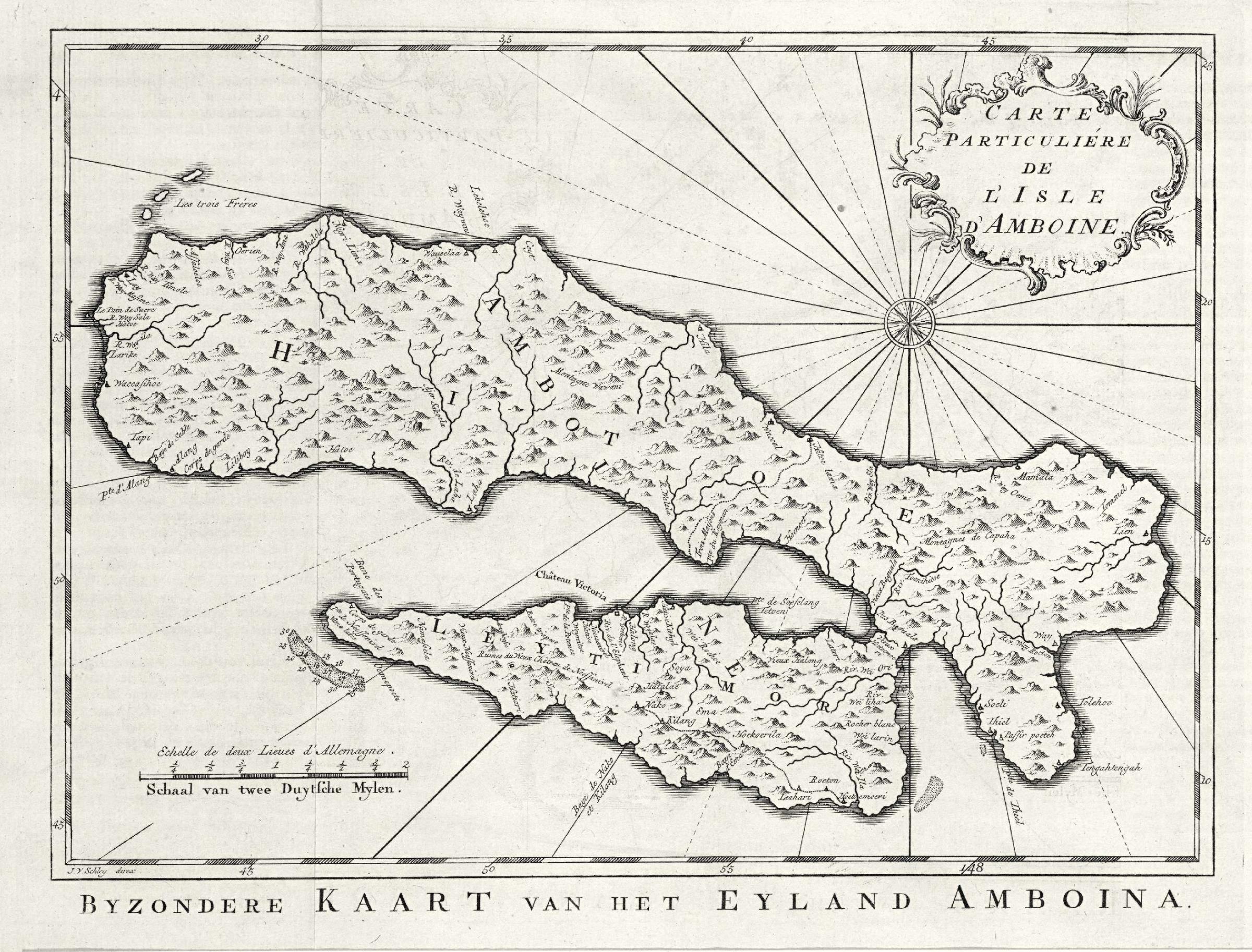
File:AMH-7994-KB Map of the island of Ambon.jpg
Original file (2,400 × 1,826 pixels, file size: 850 KB, MIME type: image/jpeg)
Captions
Captions
Summary
[edit]Nederlands: Kaart van het eiland Ambon
English: Map of the island of Ambon( |
|||||||||||||||||||||||||||||||||||||||||||||
|---|---|---|---|---|---|---|---|---|---|---|---|---|---|---|---|---|---|---|---|---|---|---|---|---|---|---|---|---|---|---|---|---|---|---|---|---|---|---|---|---|---|---|---|---|---|
| Author |
Nederlands: Pierre d' Hondt (uitgever), Jacobus van der Schley (direxit)
English: Pierre d' Hondt (publisher), Jacobus van der Schley (direxit) |
||||||||||||||||||||||||||||||||||||||||||||
| Title |
Nederlands: Kaart van het eiland Ambon
English: Map of the island of Ambon |
||||||||||||||||||||||||||||||||||||||||||||
| Description |
Nederlands: Kaart van het eiland Ambon.
Byzondere Kaart van het Eyland Amboina. / Carte Particuliére de l'Isle d'Amboine. Deze kaart is gemaakt naar het exemplaar uit 'Oud en Nieuw Oost-Indiën' van François Valentyn. Cf. Scheepvaartmuseum, Amsterdam, inv. nr. SNSM_b0032(109)06[kaart169] en Museum Bronbeek, Arnhem, inv. nr. 3113.11.English: Map of the island of Ambon.
Byzondere Kaart van het Eyland Amboina. / Carte Particulié?re de l'Isle d'Amboine. This map has been drawn on the basis of a chart included in 'Oud en Nieuw Oost-Indiën' by François Valentyn. Cf. Scheepvaartmuseum, Amsterdam, inv. nr. SNSM_b0032(109)06[chart169] and Museum Bronbeek, Arnhem, inv. nr. 3113.11. |
||||||||||||||||||||||||||||||||||||||||||||
| Date | circa 1753 | ||||||||||||||||||||||||||||||||||||||||||||
| Medium |
Nederlands: gravure op papier
English: engraving on paper |
||||||||||||||||||||||||||||||||||||||||||||
| Dimensions | height: 29.5 cm (11.6 in); width: 22.5 cm (8.8 in) | ||||||||||||||||||||||||||||||||||||||||||||
| Collection |
|
||||||||||||||||||||||||||||||||||||||||||||
| Accession number |
693 C 6 dl XI, to. p. 41 |
||||||||||||||||||||||||||||||||||||||||||||
| Inscriptions |
Byzondere Kaart van het Eyland Amboina. / Carte Particuliére de l'Isle d'Amboine
author: J.v. Schley direx |
||||||||||||||||||||||||||||||||||||||||||||
| Notes |
English: Subjects: chart / map / plan, compass / dial, banderole / cartouche / ornamentation
Nederlands: Onderwerpen: plattegrond / kaart, kompas / windroos, banderol / cartouche / versiering
English: Post: this image is related to a VOC trading post called Ambon Ourien |
||||||||||||||||||||||||||||||||||||||||||||
| Source/Photographer |
|
||||||||||||||||||||||||||||||||||||||||||||
| Permission (Reusing this file) |
|
||||||||||||||||||||||||||||||||||||||||||||

| Object location | | View this and other nearby images on: OpenStreetMap |
|---|
File history
Click on a date/time to view the file as it appeared at that time.
| Date/Time | Thumbnail | Dimensions | User | Comment | |
|---|---|---|---|---|---|
| current | 15:01, 10 June 2014 | | 2,400 × 1,826 (850 KB) | HuskyBot (talk | contribs) | == {{int:filedesc}} == {{Artwork |title = {{nl|1=Kaart van het eiland Ambon}} {{en|1=Map of the island of Ambon}} |description = {{nl|1=Kaart van het eiland Ambon. ''Byzondere Kaart van het Eyland Amboina. / C... |
You cannot overwrite this file.
File usage on Commons
The following page uses this file: