File:AMH-7997-KB Map of the Banda islands.jpg

Original file (2,400 × 2,162 pixels, file size: 1.02 MB, MIME type: image/jpeg)
Captions
Captions
Summary
[edit]Nederlands: Kaart van de Banda-eilanden
English: Map of the Banda islands( |
|||||||||||||||||||||||||||||||||||||||||||||
|---|---|---|---|---|---|---|---|---|---|---|---|---|---|---|---|---|---|---|---|---|---|---|---|---|---|---|---|---|---|---|---|---|---|---|---|---|---|---|---|---|---|---|---|---|---|
| Author |
Nederlands: Jacobus van der Schley (direxit), Pierre d' Hondt (uitgever)
English: Jacobus van der Schley (direxit), Pierre d' Hondt (publisher) |
||||||||||||||||||||||||||||||||||||||||||||
| Title |
Nederlands: Kaart van de Banda-eilanden
English: Map of the Banda islands |
||||||||||||||||||||||||||||||||||||||||||||
| Description |
Nederlands: Kaart van de Banda-eilanden.
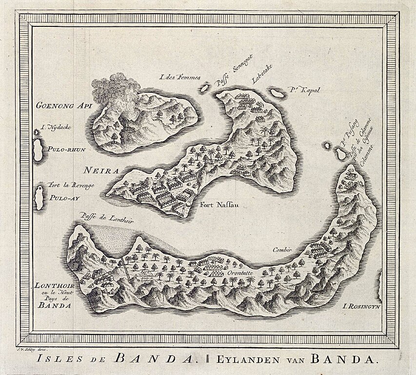
Isles de Banda / Eylanden van Banda. Van der Schley heeft deze kaart gebaseerd op die in "Het tvveede boeck, iournael oft dagh-register" van Jacob Cornelisz van Neck, p. 21. Cf. Universiteitsbibliotheek Amsterdam, inv. nr. O 60 641, 21 en Rijksmuseum Amsterdam, inv. nr. RP-P-OB-75-377 en RP-P-OB-75-391.English: Map of the Banda islands.
Isles de Banda / Eylanden van Banda. Van der Schley based this chart on one contained in "Het tvveede boeck, iournael oft dagh-register" by Jacob Cornelisz van Neck, p. 21. Cf. University Library, Amsterdam, inv. nr. O 60 641, 21 and Rijksmuseum Amsterdam, inv. nr. RP-P-OB-75-377 and RP-P-OB-75-391. |
||||||||||||||||||||||||||||||||||||||||||||
| Date | circa 1753 | ||||||||||||||||||||||||||||||||||||||||||||
| Medium |
Nederlands: gravure op papier
English: engraving on paper |
||||||||||||||||||||||||||||||||||||||||||||
| Dimensions | height: 21 cm (8.2 in); width: 18.5 cm (7.2 in) | ||||||||||||||||||||||||||||||||||||||||||||
| Collection |
|
||||||||||||||||||||||||||||||||||||||||||||
| Accession number |
693 C 6 dl XI, to. p. 93 |
||||||||||||||||||||||||||||||||||||||||||||
| Inscriptions |
Isles de Banda / Eylanden van Banda
author: J. v. Schley direx. |
||||||||||||||||||||||||||||||||||||||||||||
| Notes |
English: Subjects: chart / map / plan, bird's-eye view / elevation, elevation / bird's-eye view, building, house, fortification, banderole / cartouche / ornamentation
Nederlands: Onderwerpen: plattegrond / kaart, vogelvlucht / opstand, opstand / vogelvlucht, gebouw, huis / woonhuis, vesting, banderol / cartouche / versiering
English: Post: this image is related to a VOC trading post called Gunung Api |
||||||||||||||||||||||||||||||||||||||||||||
| Source/Photographer |
|
||||||||||||||||||||||||||||||||||||||||||||
| Permission (Reusing this file) |
|
||||||||||||||||||||||||||||||||||||||||||||

| Object location | | View this and other nearby images on: OpenStreetMap |
|---|
File history
Click on a date/time to view the file as it appeared at that time.
| Date/Time | Thumbnail | Dimensions | User | Comment | |
|---|---|---|---|---|---|
| current | 15:01, 10 June 2014 | | 2,400 × 2,162 (1.02 MB) | HuskyBot (talk | contribs) | == {{int:filedesc}} == {{Artwork |title = {{nl|1=Kaart van de Banda-eilanden}} {{en|1=Map of the Banda islands}} |description = {{nl|1=Kaart van de Banda-eilanden. ''Isles de Banda / Eylanden van Banda''. Van... |
You cannot overwrite this file.
File usage on Commons
The following page uses this file: