File:AMH-8041-KB Map of part of the coast of Venezuela.jpg
Original file (2,400 × 1,747 pixels, file size: 704 KB, MIME type: image/jpeg)
Captions
Captions
Summary[edit]
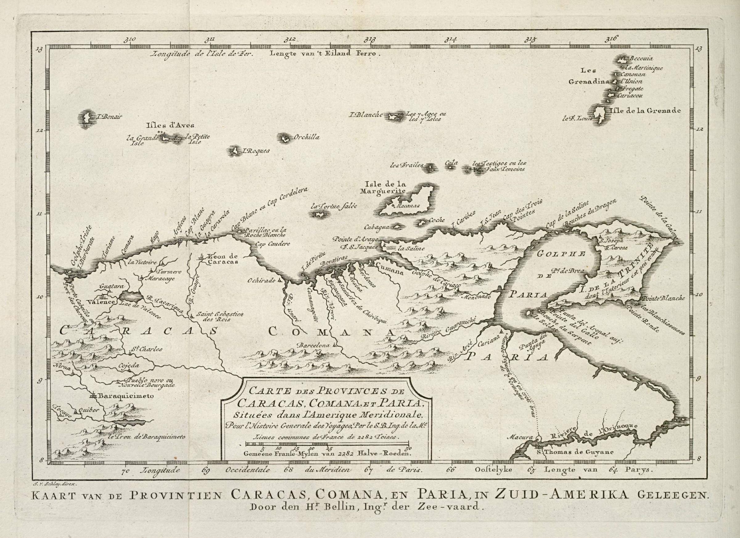
Nederlands: Kaart van een deel van de kust van Venezuela
English: Map of part of the coast of Venezuela( |
||||||||||||||||||||||||||||||||||||||||||||||||||||||||||||||||
|---|---|---|---|---|---|---|---|---|---|---|---|---|---|---|---|---|---|---|---|---|---|---|---|---|---|---|---|---|---|---|---|---|---|---|---|---|---|---|---|---|---|---|---|---|---|---|---|---|---|---|---|---|---|---|---|---|---|---|---|---|---|---|---|---|
| Author |
Nederlands: Pierre d' Hondt (uitgever), Jacobus van der Schley (direxit), Jacques Nicolas Bellin (landmeter / kaartenmaker)
English: Pierre d' Hondt (publisher), Jacobus van der Schley (direxit), Jacques Nicolas Bellin (land surveyor / mapmaker) |
|||||||||||||||||||||||||||||||||||||||||||||||||||||||||||||||
| Title |
Nederlands: Kaart van een deel van de kust van Venezuela
English: Map of part of the coast of Venezuela |
|||||||||||||||||||||||||||||||||||||||||||||||||||||||||||||||
| Description |
Nederlands: Kaart van een deel van de kust van Venezuela.
Carte des Provinces de Caracas, Comana et Paria, Situées dans l'Amerique Meridionale. Kaart van de Provintien Caracas, Comana, en Paria, in Zuid-Amerika Geleegen.English: Map of part of the coast of Venezuela.
Carte des Provinces de Caracas, Comana et Paria, Situées dans l'Amerique Meridionale. Kaart van de Provintien Caracas, Comana, en Paria, in Zuid-Amerika Geleegen. |
|||||||||||||||||||||||||||||||||||||||||||||||||||||||||||||||
| Date | 1768 | |||||||||||||||||||||||||||||||||||||||||||||||||||||||||||||||
| Medium |
Nederlands: gravure op papier
English: engraving on paper |
|||||||||||||||||||||||||||||||||||||||||||||||||||||||||||||||
| Dimensions | height: 22 cm (8.6 in); width: 16 cm (6.2 in) | |||||||||||||||||||||||||||||||||||||||||||||||||||||||||||||||
| Collection |
|
|||||||||||||||||||||||||||||||||||||||||||||||||||||||||||||||
| Accession number |
693 C 6 dl XVIII, to. p. 75 |
|||||||||||||||||||||||||||||||||||||||||||||||||||||||||||||||
| Inscriptions |
Carte des Provinces de Caracas, Comana et Paria, Situées dans l'Amerique Meridionale / Kaart van de Provintien Caracas, Comana, en Paria, in Zuid-Amerika Geleegen
author: J. v. Schley direx. / Door den Hr. Bellin, Ingr. der Zee-vaard / Par le S. B. Ing. de la Me. |
|||||||||||||||||||||||||||||||||||||||||||||||||||||||||||||||
| Notes |
English: Subjects: chart / map / plan, banderole / cartouche / ornamentation
Nederlands: Onderwerpen: plattegrond / kaart, banderol / cartouche / versiering
English: Post: this image is related to a WIC trading post called Isla la Tortuga |
|||||||||||||||||||||||||||||||||||||||||||||||||||||||||||||||
| Source/Photographer |
|
|||||||||||||||||||||||||||||||||||||||||||||||||||||||||||||||
| Permission (Reusing this file) |
|
|||||||||||||||||||||||||||||||||||||||||||||||||||||||||||||||

| Object location | | View this and other nearby images on: OpenStreetMap |
|---|
File history
Click on a date/time to view the file as it appeared at that time.
| Date/Time | Thumbnail | Dimensions | User | Comment | |
|---|---|---|---|---|---|
| current | 15:12, 10 June 2014 | | 2,400 × 1,747 (704 KB) | HuskyBot (talk | contribs) | == {{int:filedesc}} == {{Artwork |title = {{nl|1=Kaart van een deel van de kust van Venezuela}} {{en|1=Map of part of the coast of Venezuela}} |description = {{nl|1=Kaart van een deel van de kust van Venezuela.... |
You cannot overwrite this file.
File usage on Commons
The following page uses this file:
File usage on other wikis
The following other wikis use this file:
- Usage on lij.wikipedia.org