File:A chart of the N.E. coast of Cape Breton Island, from St Ann Bay to Cape Morien. RMG K0849.jpg
Jump to navigation
Jump to search
Size of this preview: 800 × 406 pixels. Other resolutions: 320 × 163 pixels | 640 × 325 pixels | 1,280 × 650 pixels.
Original file (1,280 × 650 pixels, file size: 447 KB, MIME type: image/jpeg)
Captions
Captions
Add a one-line explanation of what this file represents
Summary[edit]
| Author |
Des Barres; Joseph Frederick Wallet Des Barres |
| Description |
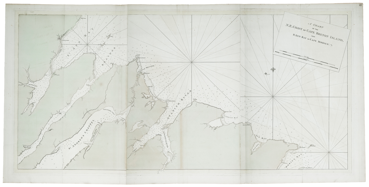
English: A chart of the N.E. coast of Cape Breton Island, from St Ann Bay to Cape Morien.Three sheets. Engraved. Scale: ca. 1:48 000. Cartographic Note: Variation shown 17 degrees 30' W. Ungraduated. Bar scales in statute and nautical miles. Plate same as HNS136A. Other features: Printed on Bates paper. Border yellow, land green, settlements tinted. Page number '15' on a paper rectangle pasted top right. HNS 136B A chart of the N.E. coast of Cape Breton Island, from St Ann Bay to Cape Morien. |
| Date | circa 1780 |
| Dimensions | Plate impressions 78 x >53.5cm, 78 x >53cm and 78 x >53cm. |
| Notes | Associated Materials: One of the three copper plates is held by Library and Archives Canada, in Ottawa. |
| Source/Photographer | http://collections.rmg.co.uk/collections/objects/560653 |
| Permission (Reusing this file) |
The original artefact or artwork has been assessed as public domain by age, and faithful reproductions of the two dimensional work are also public domain. No permission is required for reuse for any purpose. The text of this image record has been derived from the Royal Museums Greenwich catalogue and image metadata. Individual data and facts such as date, author and title are not copyrightable, but reuse of longer descriptive text from the catalogue may not be considered fair use. Reuse of the text must be attributed to the "National Maritime Museum, Greenwich, London" and a Creative Commons CC-BY-NC-SA-3.0 license may apply if not rewritten. Refer to Royal Museums Greenwich copyright. |
| Identifier | id number: HNS136B previous number: HNS 136 |
| Collection | Charts and maps |
Licensing[edit]
|
This is a faithful photographic reproduction of a two-dimensional, public domain work of art. The work of art itself is in the public domain for the following reason:
The official position taken by the Wikimedia Foundation is that "faithful reproductions of two-dimensional public domain works of art are public domain".
This photographic reproduction is therefore also considered to be in the public domain in the United States. In other jurisdictions, re-use of this content may be restricted; see Reuse of PD-Art photographs for details. | ||||
File history
Click on a date/time to view the file as it appeared at that time.
| Date/Time | Thumbnail | Dimensions | User | Comment | |
|---|---|---|---|---|---|
| current | 16:32, 29 August 2017 | | 1,280 × 650 (447 KB) | Fæ (talk | contribs) | Royal Museums Greenwich Charts and maps, http://collections.rmg.co.uk/collections/objects/560653 |
You cannot overwrite this file.
File usage on Commons
The following page uses this file: