File:A map of New-England, being the first that ever was here cut, and done by the best pattern that could be had, which being in some places defective, it made the other less exact- Yet doth it LOC gm71002303.jpg
Jump to navigation
Jump to search

Size of this preview: 641 × 599 pixels. Other resolutions: 257 × 240 pixels | 514 × 480 pixels | 822 × 768 pixels | 1,096 × 1,024 pixels | 2,191 × 2,048 pixels | 4,913 × 4,592 pixels.
Original file (4,913 × 4,592 pixels, file size: 4.51 MB, MIME type: image/jpeg)
Captions
Captions
Add a one-line explanation of what this file represents
Summary[edit]
| Description |
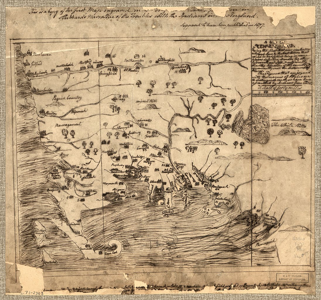
English: Scale ca. 1:900,000. Manuscript, pen-and-ink. Oriented with north to the right. Relief shown pictorially. "This is a copy of the first map engraved in New England. Taken from one in Hubbard's Narrative of the troubles with the Indians in New England, supposed to have been published in 1677." "The figures that are joyned with the names of places are to distinguish such as have been assaulted by Indians from others." Imperfect: Legend in lower margin largely wanting. Available also through the Library of Congress Web site as a raster image. Vault AACR2 |
||
| Title | A map of New-England, being the first that ever was here cut, and done by the best pattern that could be had, which being in some places defective, it made the other less exact: Yet doth it sufficiently show the situation of the country & conveniently well the distances of places. | ||
| Shelf ID | G3720 1677 .H81 | ||
| Date | |||
| Source | https://www.loc.gov/item/gm71002303/ | ||
| Author | Hubbard, William | ||
| Permission (Reusing this file) |
|
||
| Other versions |
|
||
| Location | United States · New England. · New England · United States | ||
| Part of | American Memory · General Maps · Catalog · Geography And Map Division | ||
| Subject | United States · Maps, Manuscript · New England · Early Works To 1800 |


Licensing[edit]
|
This is a faithful photographic reproduction of a two-dimensional, public domain work of art. The work of art itself is in the public domain for the following reason:
The official position taken by the Wikimedia Foundation is that "faithful reproductions of two-dimensional public domain works of art are public domain".
This photographic reproduction is therefore also considered to be in the public domain in the United States. In other jurisdictions, re-use of this content may be restricted; see Reuse of PD-Art photographs for details. | ||||
File history
Click on a date/time to view the file as it appeared at that time.
| Date/Time | Thumbnail | Dimensions | User | Comment | |
|---|---|---|---|---|---|
| current | 04:23, 3 June 2018 | | 4,913 × 4,592 (4.51 MB) | Fæ (talk | contribs) | LOC Maps https://www.loc.gov/item/gm71002303/ #18598 |
You cannot overwrite this file.
File usage on Commons
The following page uses this file: