File:A new chart of the river St. Laurence, from the island of Anticosti to the falls of Richelieu- With all the islands, rocks, shoals, and soundings, also particular directions for navigating the river LOC 73697227.jpg
Jump to navigation
Jump to search

Size of this preview: 800 × 303 pixels. Other resolutions: 320 × 121 pixels | 640 × 243 pixels | 1,024 × 388 pixels | 1,280 × 485 pixels | 2,560 × 970 pixels | 28,917 × 10,958 pixels.
Original file (28,917 × 10,958 pixels, file size: 29.03 MB, MIME type: image/jpeg)
Captions
Captions
Add a one-line explanation of what this file represents
Summary[edit]
| Warning | The original file is very high-resolution. It might not load properly or could cause your browser to freeze when opened at full size. |
|---|
| Description |
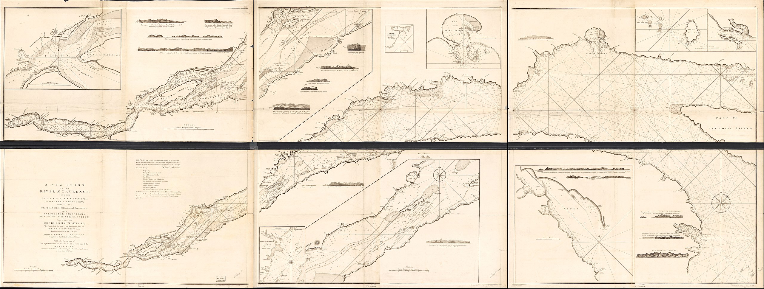
English: Scale ca. 1:150,000. Relief shown pictorially and by hachures. Depths shown in fathoms. Each sheet composed of 4 sections glued together. "This chart was drawn from particular surveys of the following places; and published for the use of British navigators, by command of the Right Honourable the Lords Commissioners of the Admiralty, Charles Saunder, Pall Mall, May 1st., 1760." Shows settlements, ship channels, and anchorages. Appears in the author's The North American Pilot for Newfoundland, Labradore, the gulf and river St. Laurence. 1777. Pl. no.: XXII, XXI, XX. Includes text, 17 coastal views, and 9 insets. LC Maps of North America, 1750-1789, 235 Available also through the Library of Congress Web site as a raster image. Vault AACR2 |
||
| Title | A new chart of the river St. Laurence, from the island of Anticosti to the falls of Richelieu: With all the islands, rocks, shoals, and soundings, also particular directions for navigating the river with safety. Taken by the order of Charles Saunders, Esqr. ... in the expedition against Quebec in 1759. | ||
| Shelf ID | G3312.S5P5 1775 .J43 | ||
| Date | |||
| Source | https://www.loc.gov/item/73697227/ | ||
| Author | Jefferys, Thomas; Robert Sayer And John Bennett (Firm) | ||
| Permission (Reusing this file) |
|
||
| Location | Saint Lawrence River · North America | ||
| Part of | Military Battles And Campaigns · American Memory · Catalog · Geography And Map Division · American Revolution And Its Era: Maps And Charts Of North America And The West Indies, 1750-1789 | ||
| Subject | Saint Lawrence River · Maps · Early Works To 1800 · Nautical Charts · North America |

Licensing[edit]
|
This is a faithful photographic reproduction of a two-dimensional, public domain work of art. The work of art itself is in the public domain for the following reason:
The official position taken by the Wikimedia Foundation is that "faithful reproductions of two-dimensional public domain works of art are public domain".
This photographic reproduction is therefore also considered to be in the public domain in the United States. In other jurisdictions, re-use of this content may be restricted; see Reuse of PD-Art photographs for details. | ||||
File history
Click on a date/time to view the file as it appeared at that time.
| Date/Time | Thumbnail | Dimensions | User | Comment | |
|---|---|---|---|---|---|
| current | 21:36, 18 May 2018 | 28,917 × 10,958 (29.03 MB) | Fæ (talk | contribs) | LOC Maps https://www.loc.gov/item/73697227/ #2010 |
You cannot overwrite this file.
File usage on Commons
There are no pages that use this file.