File:A new map of North & South Carolina, & Georgia LOC 2013593291.jpg
Jump to navigation
Jump to search

Size of this preview: 757 × 600 pixels. Other resolutions: 303 × 240 pixels | 606 × 480 pixels | 969 × 768 pixels | 1,280 × 1,014 pixels | 2,560 × 2,029 pixels | 3,653 × 2,895 pixels.
Original file (3,653 × 2,895 pixels, file size: 1.45 MB, MIME type: image/jpeg)
Captions
Captions
Add a one-line explanation of what this file represents
Summary
[edit]| Description |
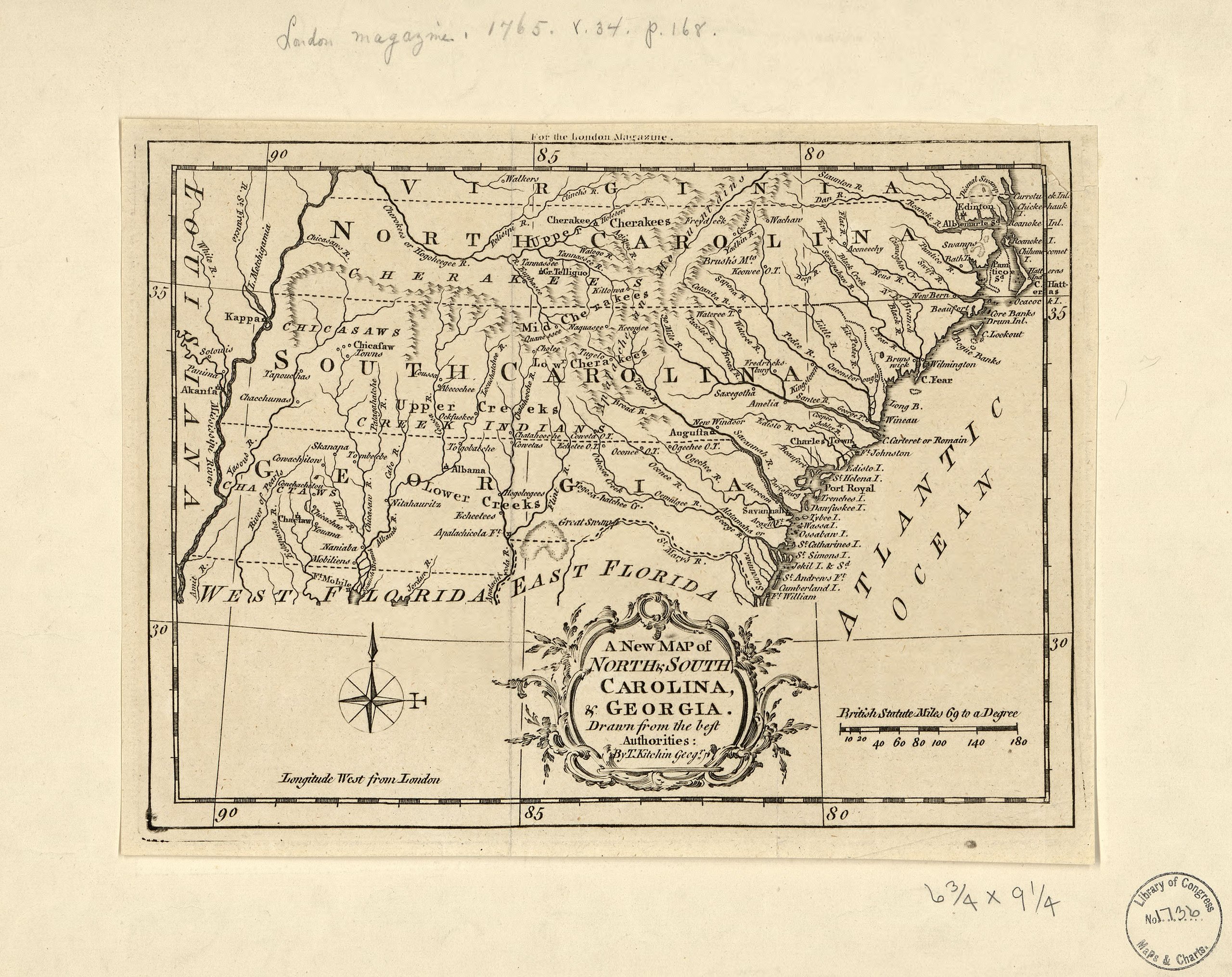
English: Shows the boundaries of each of the above provinces extend from the Atlantic coast to the Mississippi River. Also shows towns along the coast, Indian villages and tribal territory, forts principal rivers, and relief. Relief shown by hachures. From The London magazine or Gentleman's monthly intelligencer. (April, 1765), vol. 34. Prime meridian: London. LC Maps of North America, 1750-1789, 1390 Available also through the Library of Congress Web site as a raster image. LC copy imperfect: Torn and detached in upper right corner. |
||
| Title | A new map of North & South Carolina, & Georgia | ||
| Shelf ID | G3900 1765 .K5 | ||
| Date | |||
| Source | https://www.loc.gov/item/2013593291/ | ||
| Author | Kitchin, Thomas | ||
| Permission (Reusing this file) |
|
||
| Other versions |
|
||
| Location | South Carolina · United States · Georgia · Southern States · North Carolina | ||
| Part of | Military Battles And Campaigns · American Memory · Catalog · Geography And Map Division · American Revolution And Its Era: Maps And Charts Of North America And The West Indies, 1750-1789 | ||
| Subject | Early Maps · Georgia · North Carolina · United States · Maps · Early Works To 1800 · Southern States · South Carolina |


Licensing
[edit]
|
This is a faithful photographic reproduction of a two-dimensional, public domain work of art. The work of art itself is in the public domain for the following reason:
The official position taken by the Wikimedia Foundation is that "faithful reproductions of two-dimensional public domain works of art are public domain".
This photographic reproduction is therefore also considered to be in the public domain in the United States. In other jurisdictions, re-use of this content may be restricted; see Reuse of PD-Art photographs for details. | ||||
File history
Click on a date/time to view the file as it appeared at that time.
| Date/Time | Thumbnail | Dimensions | User | Comment | |
|---|---|---|---|---|---|
| current | 11:53, 25 May 2018 | | 3,653 × 2,895 (1.45 MB) | Fæ (talk | contribs) | LOC Maps https://www.loc.gov/item/2013593291/ #14901 |
You cannot overwrite this file.
File usage on Commons
The following page uses this file: