File:A plan of the land between Fort Mossy and St. Augustine in the province of East Florida. LOC 73691558.jpg
Jump to navigation
Jump to search

Size of this preview: 753 × 599 pixels. Other resolutions: 302 × 240 pixels | 603 × 480 pixels | 965 × 768 pixels | 1,280 × 1,019 pixels | 2,560 × 2,038 pixels | 5,064 × 4,031 pixels.
Original file (5,064 × 4,031 pixels, file size: 2.45 MB, MIME type: image/jpeg)
Captions
Captions
Add a one-line explanation of what this file represents
Summary[edit]
| Description |
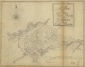
English: Scale ca. 1:7,900. Manuscript, pen-and-ink. Has watermarks. Oriented with north to the right. Shows "Spanish old fields overgrown with scrubs." LC Maps of North America, 1750-1789, 1635 LC Luso-Hispanic World, 879 Available also through the Library of Congress Web site as a raster image. |
||
| Title | A plan of the land between Fort Mossy and St. Augustine in the province of East Florida. | ||
| Shelf ID | G3934.S2A1 176- .R6 | ||
| Date | |||
| Source | https://www.loc.gov/item/73691558/ | ||
| Author | Roworth, Sam | ||
| Permission (Reusing this file) |
|
||
| Other versions |
|
||
| Location | United States · Saint Augustine Region · Florida | ||
| Part of | Cultural Landscapes · Military Battles And Campaigns · Catalog · American Memory · Geography And Map Division · American Revolution And Its Era: Maps And Charts Of North America And The West Indies, 1750-1789 | ||
| Subject | Maps, Manuscript · Saint Augustine Region · Florida · Saint Augustine Region (Fla.) · United States · Early Works To 1800 · Manuscript Maps |

Licensing[edit]
|
This is a faithful photographic reproduction of a two-dimensional, public domain work of art. The work of art itself is in the public domain for the following reason:
The official position taken by the Wikimedia Foundation is that "faithful reproductions of two-dimensional public domain works of art are public domain".
This photographic reproduction is therefore also considered to be in the public domain in the United States. In other jurisdictions, re-use of this content may be restricted; see Reuse of PD-Art photographs for details. | ||||
File history
Click on a date/time to view the file as it appeared at that time.
| Date/Time | Thumbnail | Dimensions | User | Comment | |
|---|---|---|---|---|---|
| current | 01:04, 19 June 2018 | | 5,064 × 4,031 (2.45 MB) | Fæ (talk | contribs) | LOC Maps https://www.loc.gov/item/73691558/ #20187 |
You cannot overwrite this file.
File usage on Commons
The following page uses this file: