File:Aerial image of the Eggstätt-Hemhof Lakes (view from the southwest).jpg
Jump to navigation
Jump to search

Size of this preview: 800 × 576 pixels. Other resolutions: 320 × 230 pixels | 640 × 461 pixels | 1,024 × 737 pixels | 1,280 × 922 pixels | 2,560 × 1,843 pixels | 5,000 × 3,600 pixels.
Original file (5,000 × 3,600 pixels, file size: 8.37 MB, MIME type: image/jpeg)
Captions
Captions
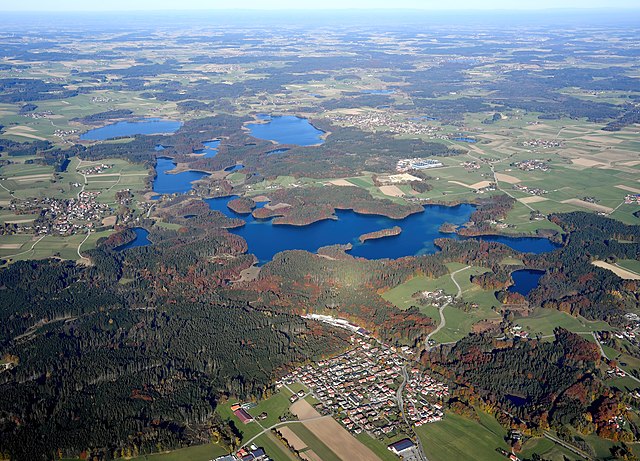
Aerial image of the Eggstätt-Hemhof Lakes (view from the southwest)
Summary[edit]
.jpg&action=edit§ion=1)
| Description |
English: Aerial image of the Eggstätt-Hemhof Lakes (view from the southwest)
Deutsch: Luftbild der Eggstätt-Hemhofer Seenplatte (Ansicht von Südwesten) |
| Date | |
| Source | Own work |
| Author | Carsten Steger |
| Camera location | | View this and other nearby images on: OpenStreetMap |
|---|
.jpg¶ms=047.875338_N_0012.326699_E_globe:Earth_type:camera_heading:40.00&language=en)
| Object location | | View this and other nearby images on: OpenStreetMap |
|---|
.jpg¶ms=047.920000_N_0012.360000_E_globe:Earth_class:object_type:object__&language=en)
Licensing[edit]
.jpg&action=edit§ion=2)
I, the copyright holder of this work, hereby publish it under the following license:
This file is licensed under the Creative Commons Attribution-Share Alike 4.0 International license.
- You are free:
- to share – to copy, distribute and transmit the work
- to remix – to adapt the work
- Under the following conditions:
- attribution – You must give appropriate credit, provide a link to the license, and indicate if changes were made. You may do so in any reasonable manner, but not in any way that suggests the licensor endorses you or your use.
- share alike – If you remix, transform, or build upon the material, you must distribute your contributions under the same or compatible license as the original.
| Annotations | This image is annotated: View the annotations at Commons |
.jpg)
File history
Click on a date/time to view the file as it appeared at that time.
| Date/Time | Thumbnail | Dimensions | User | Comment | |
|---|---|---|---|---|---|
| current | 17:29, 30 January 2022 | | 5,000 × 3,600 (8.37 MB) | Carsten Steger (talk | contribs) | Uploaded own work with UploadWizard |
You cannot overwrite this file.
File usage on Commons
The following 2 pages use this file:
File usage on other wikis
The following other wikis use this file:
- Usage on de.wikipedia.org
- Liste von Seen in Bayern
- Eggstätt-Hemhofer Seenplatte
- Toteissee
- Liste der Naturschutzgebiete in der Stadt und Landkreis Rosenheim
- Liste der Naturschutzgebiete in Oberbayern
- Liste der EU-Vogelschutzgebiete in Oberbayern
- Liste der EU-Vogelschutzgebiete in Bayern
- Liste der FFH-Gebiete in Oberbayern
- Liste der FFH-Gebiete im Landkreis Rosenheim
- Benutzer:Derzno/EU Vogelschutzgebiete in Bayern
- Benutzer:BurghardRichter/Entwurf
- Usage on www.wikidata.org
.jpg&oldid=782612238)