File:Ancient Epirus & Modern Borders (Colored).svg
Jump to navigation
Jump to search

Size of this PNG preview of this SVG file: 411 × 599 pixels. Other resolutions: 165 × 240 pixels | 329 × 480 pixels | 527 × 768 pixels | 703 × 1,024 pixels | 1,406 × 2,048 pixels | 688 × 1,002 pixels.
Original file (SVG file, nominally 688 × 1,002 pixels, file size: 175 KB)
Captions
Captions
Add a one-line explanation of what this file represents
Summary[edit]
.svg&action=edit§ion=1)
| Description |
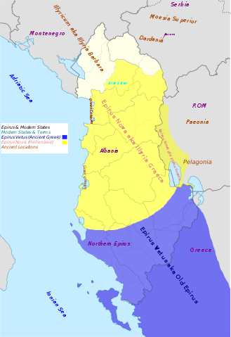
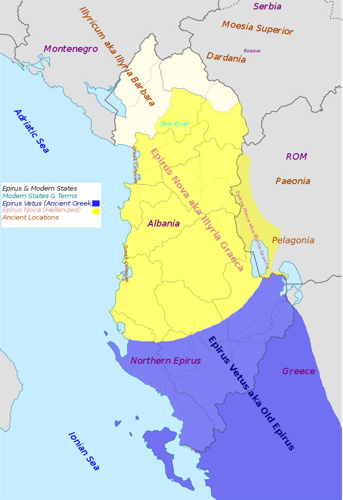
English: Map of "The Ancient Greek region of Epirus and the Situation today".Approximate extent of Ancient Epirus,Epirus Vetus,Epirus Nova (Illyria Graeca) and adjoining Provinces and regions. The expansion of the Greek region of Epirus into Illyria. Anachronistic. |
| Date | |
| Source | Own work |
| Author | MaryroseB54 |
| Other versions |
 |
- American journal of philology, Τόμοι 98-99,by JSTOR (Organization), Project Muse,1977,page 263, the partly Hellenic and partly Hellenized Epirus Nova
- Epirus Vetus: The Archaeology of a Late Antique Province (Duckworth Archaeology) by William Bowden,2003,ISBN-10: 0715631160,2003,page 233,of Lissos in Epirus Nova
- Migrations and invasions in Greece and adjacent areas by Nicholas Geoffrey Lemprière Hammond,1976,ISBN -0815550472,page 54,The line of division between Illyricum and the Greek area Epirus nova
- Hammond, N. G. L. A History of Greece to 322 B.C., 1986, ISBN-10: 0198730950
- Triadafilopoulos, Triadafilos (November 2000). "Power politics and nationalist discourse in the struggle for 'Northern Epirus': 1919-1921". Journal of Southern Europe and the Balkans,
- Encyclopedia Britannica,2002,ISBN -0852297874,The Roman province of Illyricum stretched from the Drilon River (the Drin, in modern Albania) in the south to Istria (modem Slovenia and Croatia)
- The Illyrians (The Peoples of Europe) by John Wilkes,1996,ISBN-9780631198079,Wilkes gives the limites of Epirus Nova at Drilon river
- The Illyrians (The Peoples of Europe) by John Wilkes,1996,ISBN-9780631198079,page 208
- History of the Byzantine Empire: Vol. 1, 324-1453 (Paperback) by Alexander A. Vasiliev
- File:Albania_location_map.svg
Licensing[edit]
.svg&action=edit§ion=2)
I, the copyright holder of this work, hereby publish it under the following license:
This file is licensed under the Creative Commons Attribution-Share Alike 4.0 International license.
- You are free:
- to share – to copy, distribute and transmit the work
- to remix – to adapt the work
- Under the following conditions:
- attribution – You must give appropriate credit, provide a link to the license, and indicate if changes were made. You may do so in any reasonable manner, but not in any way that suggests the licensor endorses you or your use.
- share alike – If you remix, transform, or build upon the material, you must distribute your contributions under the same or compatible license as the original.
File history
Click on a date/time to view the file as it appeared at that time.
| Date/Time | Thumbnail | Dimensions | User | Comment | |
|---|---|---|---|---|---|
| current | 09:44, 3 July 2016 | | 688 × 1,002 (175 KB) | MaryroseB54 (talk | contribs) | User created page with UploadWizard |
You cannot overwrite this file.
File usage on Commons
The following 10 pages use this file:
-pt.svg)
File usage on other wikis
The following other wikis use this file:
- Usage on cs.wikipedia.org
- Usage on el.wikipedia.org
- Usage on en.wikipedia.org
- Usage on es.wikipedia.org
- Usage on et.wikipedia.org
- Usage on fr.wikipedia.org
- Usage on gl.wikipedia.org
- Usage on it.wikipedia.org
- Usage on lt.wikipedia.org
- Usage on mk.wikipedia.org
- Usage on nl.wikipedia.org
- Usage on sk.wikipedia.org
- Usage on sl.wikipedia.org
- Usage on sq.wikipedia.org
Metadata
.svg&oldid=792049072)
Categories:
- English-language SVG maps showing history
- Maps of the history of Albania in ancient times
- Maps of the history of Greece
- Maps of the history of North Macedonia in ancient times
- Maps of the Byzantine Empire
- Roman Macedonia
- Maps of Epirus
- Anachronistic maps
- Northern Epirus
- Maps of the history of the ancient Balkans
- Maps of the history of Montenegro in ancient times
- Maps of the history of Kosovo