File:Androscoggin County Maine Incorporated Areas Mechanic Falls Highlighted.png
Jump to navigation
Jump to search
No higher resolution available.
Androscoggin_County_Maine_Incorporated_Areas_Mechanic_Falls_Highlighted.png (450 × 386 pixels, file size: 31 KB, MIME type: image/png)
Captions
Captions
Add a one-line explanation of what this file represents
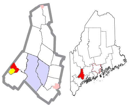
| Description | Map of the divisions of Androscoggin County, Maine, United States, with Mechanic Falls highlighted: the census-designated place of Mechanic Falls in red, and the rest of the town of Mechanic Falls in yellow. The cities of Auburn and Lewiston are light blue; other towns are white; and pink areas are census-designated places within other towns. | ||
| Date | |||
| Source | Modified by me from this United States Census Bureau file. | ||
| Author | Nyttend | ||
| Permission (Reusing this file) |
US Government work is public domain, and my work is
|
File history
Click on a date/time to view the file as it appeared at that time.
| Date/Time | Thumbnail | Dimensions | User | Comment | |
|---|---|---|---|---|---|
| current | 20:25, 25 June 2008 | | 450 × 386 (31 KB) | Nyttend (talk | contribs) | {{Information |Description=Map of the divisions of {{w|Androscoggin County, Maine|Androscoggin County}}, {{w|Maine}}, {{w|United States}}, with Mechanic Falls highlighted: the {{w|census-designated place}} of {{w|Mechanic Falls (CDP), Maine|Mechanic Falls |
You cannot overwrite this file.
File usage on Commons
The following page uses this file:
File usage on other wikis
The following other wikis use this file:
- Usage on ar.wikipedia.org
- Usage on cy.wikipedia.org
- Usage on en.wikipedia.org
- Usage on eu.wikipedia.org
- Usage on fa.wikipedia.org
- Usage on fr.wikipedia.org
- Usage on ht.wikipedia.org
- Usage on it.wikipedia.org
- Usage on sh.wikipedia.org
- Usage on sr.wikipedia.org
- Usage on tt.wikipedia.org
- Usage on vo.wikipedia.org
- Usage on www.wikidata.org
- Usage on zh.wikipedia.org