File:Antarctica altitudes draft.jpg
Jump to navigation
Jump to search
Size of this preview: 600 × 600 pixels. Other resolutions: 240 × 240 pixels | 480 × 480 pixels | 768 × 768 pixels | 1,024 × 1,024 pixels | 1,400 × 1,400 pixels.
Original file (1,400 × 1,400 pixels, file size: 581 KB, MIME type: image/jpeg)
Captions
Captions
Add a one-line explanation of what this file represents
| Description |
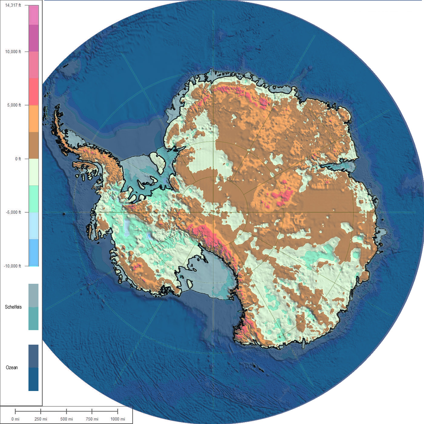
Deutsch: Karte der subglazialen Topografie und Bathymetrie der Antarktis. Zur besseren visuellen Abgrenzung von Ozean, Schelfeis und Land wurden die Ozeangebiete dukelblau und die Schelfeisgebiete mittelblau abgedunkelt. Jede Farbstufe entspricht 2.500 Fuß (762 m). Die dicke durchgezogene Linie zeigt den Umriss von Antarktika, die dünne gestrichelte Linie das Schelfeis. Entwurf zur Diskussion der Karte in der Wikipedia-Kartenwerkstatt. |
| Date | (UTC) |
| Source | |
| Author |
|
| This is a retouched picture, which means that it has been digitally altered from its original version. Modifications: Farbskala modifiziert, Ozean und Schelfeis blau abgedunkelt. The original can be viewed here: AntarcticBedrock with outline.jpg:
|
I, the copyright holder of this work, hereby publish it under the following license:
This file is licensed under the Creative Commons Attribution-Share Alike 3.0 Unported license.
- You are free:
- to share – to copy, distribute and transmit the work
- to remix – to adapt the work
- Under the following conditions:
- attribution – You must give appropriate credit, provide a link to the license, and indicate if changes were made. You may do so in any reasonable manner, but not in any way that suggests the licensor endorses you or your use.
- share alike – If you remix, transform, or build upon the material, you must distribute your contributions under the same or compatible license as the original.
Original upload log[edit]
This image is a derivative work of the following images:
- File:AntarcticBedrock_with_outline.jpg licensed with Cc-by-sa-3.0
- 2011-05-06T15:00:44Z NordNordWest 1400x1400 (1242460 Bytes) {{Information |Description={{de|1=Karte der subglazialen Topografie und Bathymetrie der Antarktis. Blau- und Violett-Töne zeigen die untermeerischen Gebiete bzw. Gebiete unter dem Inlandeis, die sich unterhalb des Meeresspie
Uploaded with derivativeFX
File history
Click on a date/time to view the file as it appeared at that time.
| Date/Time | Thumbnail | Dimensions | User | Comment | |
|---|---|---|---|---|---|
| current | 16:19, 8 May 2011 | | 1,400 × 1,400 (581 KB) | Neitram (talk | contribs) | {{Information |Description={{de|1=Karte der subglazialen Topografie und Bathymetrie der Antarktis. Zur besseren visuellen Abgrenzung von Ozean, Schelfeis und Land wurden die Ozeangebiete dukelblau und die Schelfeisgebiete mittelblau abgedunkelt. Jede Farb |
You cannot overwrite this file.
File usage on Commons
There are no pages that use this file.
File usage on other wikis
The following other wikis use this file:
- Usage on de.wikipedia.org
- Usage on pl.wikipedia.org