File:Arctic Carbon Dioxide, March 23, 2010 (8270694102).jpg
Original file (1,920 × 1,080 pixels, file size: 95 KB, MIME type: image/jpeg)
Captions
Captions
Summary[edit]
.jpg&action=edit§ion=1)
| Description |
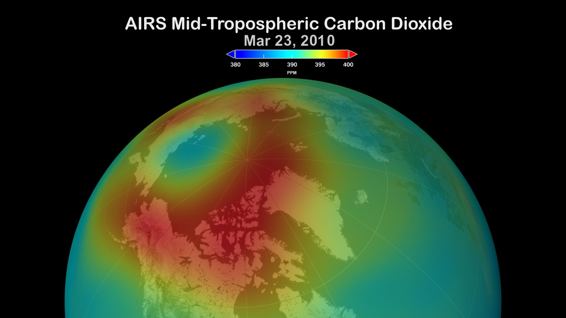
English: The Atmospheric Infrared Sounder, AIRS, was launched aboard the Aqua Spacecraft in 2002 as part of NASA's Earth Observing System Afternoon Constellation of satellites known as the 'A-Train. The most important trace gas retrieved by AIRS for the study of anthropogenic effects on climate is carbon dioxide. AIRS CO2 retrievals use an analytical method for the determination of carbon dioxide and other minor gases in the troposphere from AIRS spectra. AIRS has provided the first satellite retrieval of mid-tropospheric CO2 under cloudy conditions, without the use of a priori information from models. AIRS retrievals use cloud-cleared thermal IR radiance spectra in the 15 micron band with an accuracy better than 2 ppm, making it ideal for mapping the distribution and transport of carbon dioxide levels in the free troposphere.
Arctic CO2 in the mid-troposphere (8-12 km altitude) over the period February 2010 through February 2011. The AIRS data have been combined over a 9-day window and then assimilated by a Fixed Rank Kriging (FRK) process that smoothes the data based upon spatial covariances that are neither stationary nor isotropic. The FRK methodology was developed by a group in the Program in Spatial Statistics and Environmental Sciences at The Ohio State University. ______________________________________________________________________ About AIRS The Atmospheric Infrared Sounder, AIRS, in conjunction with the Advanced Microwave Sounding Unit, AMSU, sense emitted infrared and microwave radiation from the Earth to provide a three-dimensional look at Earth's weather and climate. Working in tandem, the two instruments make simultaneous observations all the way down to the Earth's surface, even in the presence of heavy clouds. With more than 2,000 channels sensing different regions of the atmosphere, the system creates a global, 3-dimensional map of atmospheric temperature and humidity, cloud amounts and heights, greenhouse gas concentrations, and many other atmospheric phenomena. The AIRS and AMSU fly onboard NASA's Aqua spacecraft and are managed by the Jet Propulsion Laboratory, Pasadena, California, under contract to NASA. JPL is a division of the California Institute of Technology in Pasadena. Credit NASA/JPL AIRS Project NASA/Goddard Space Flight Center Scientific Visualization Studio Download the image Various sizes of the image are available, and there are two ways to download: 1) Right-click on the image. Click on a size next to "View all sizes". 2) Click on the "Actions" menu located above the image. Select "View all sizes". Resources Additional formats and stills › "Trapped in the Troposphere" › Atmospheric Infrared Sounder web site › How to get the AIRS data Data Products › Data Portals › Documentation › |
| Date | Taken on 1 April 2011, 12:43:02 |
| Source | Arctic Carbon Dioxide, March 23, 2010 |
| Author | Atmospheric Infrared Sounder |
| Flickr set | Carbon Dioxide |
| Flickr tags | atmosphericinfraredsounder; nasa; carbondioxide; airs; arctic; jpl |
Licensing[edit]
.jpg&action=edit§ion=2)
- You are free:
- to share – to copy, distribute and transmit the work
- to remix – to adapt the work
- Under the following conditions:
- attribution – You must give appropriate credit, provide a link to the license, and indicate if changes were made. You may do so in any reasonable manner, but not in any way that suggests the licensor endorses you or your use.
| This image was originally posted to Flickr by Atmospheric Infrared Sounder at https://flickr.com/photos/90896682@N06/8270694102. It was reviewed on 25 September 2023 by FlickreviewR 2 and was confirmed to be licensed under the terms of the cc-by-2.0. |
| This file is in the public domain in the United States because it was solely created by NASA. NASA copyright policy states that "NASA material is not protected by copyright unless noted". (See Template:PD-USGov, NASA copyright policy page or JPL Image Use Policy.) | ||
 |
Warnings:
|
File history
Click on a date/time to view the file as it appeared at that time.
| Date/Time | Thumbnail | Dimensions | User | Comment | |
|---|---|---|---|---|---|
| current | 01:00, 25 September 2023 | | 1,920 × 1,080 (95 KB) | OptimusPrimeBot (talk | contribs) | #Spacemedia - Upload of https://live.staticflickr.com/8479/8270694102_d1dcdcdfb5_o.jpg via Commons:Spacemedia |
You cannot overwrite this file.
File usage on Commons
There are no pages that use this file.
.jpg&oldid=853443728)