File:Bahnstrecke Kufstein–Innsbruck.png
Jump to navigation
Jump to search

Size of this preview: 800 × 529 pixels. Other resolutions: 320 × 212 pixels | 640 × 423 pixels | 1,024 × 677 pixels | 1,280 × 847 pixels | 2,560 × 1,693 pixels | 4,079 × 2,698 pixels.
Original file (4,079 × 2,698 pixels, file size: 4.32 MB, MIME type: image/png)
Captions
Captions
Add a one-line explanation of what this file represents
Summary
[edit]
| Description |
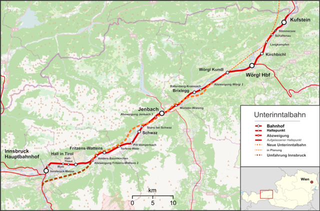
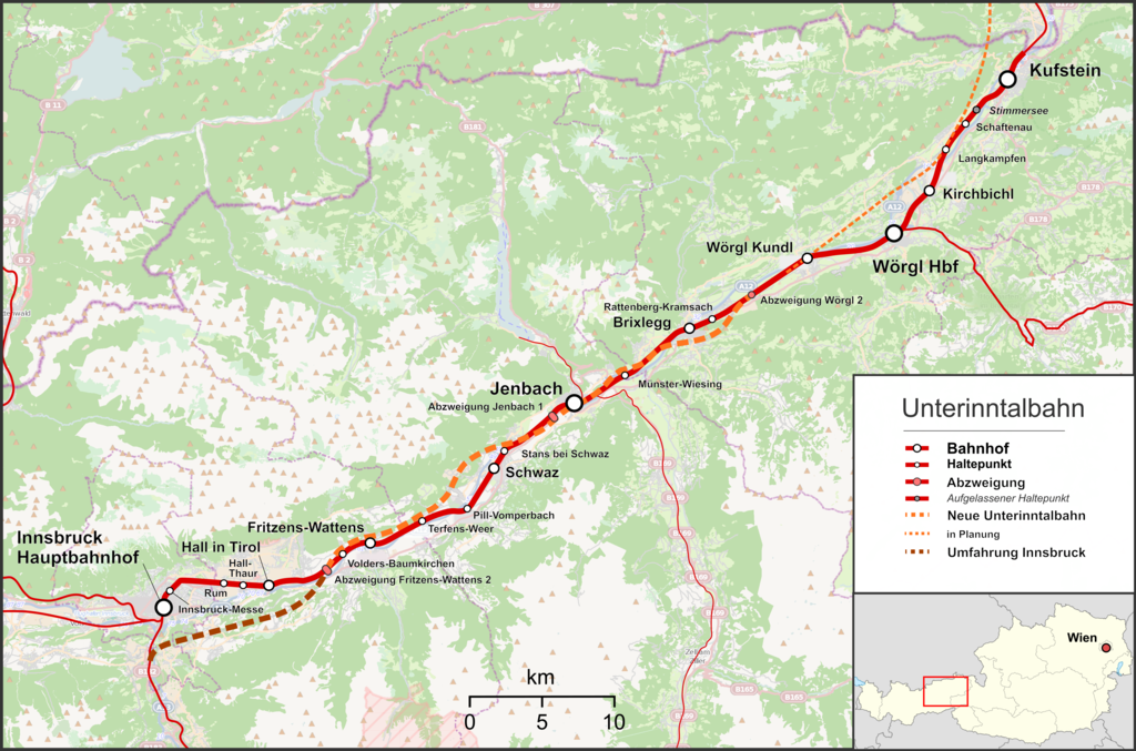
English: Map of Lower Inn Valley Railway
Deutsch: Karte der Unterinntalbahn |
| Date | |
| Source |
Own work Map was created using:
|
| Author | |
| Permission (Reusing this file) |
Map data (c) OpenStreetMap (and) contributors, CC-BY-SA |
Licensing
[edit]
This file is licensed under the Creative Commons Attribution-Share Alike 2.0 Generic license.
- You are free:
- to share – to copy, distribute and transmit the work
- to remix – to adapt the work
- Under the following conditions:
- attribution – You must give appropriate credit, provide a link to the license, and indicate if changes were made. You may do so in any reasonable manner, but not in any way that suggests the licensor endorses you or your use.
- share alike – If you remix, transform, or build upon the material, you must distribute your contributions under the same or compatible license as the original.
File history
Click on a date/time to view the file as it appeared at that time.
| Date/Time | Thumbnail | Dimensions | User | Comment | |
|---|---|---|---|---|---|
| current | 11:28, 20 April 2022 | | 4,079 × 2,698 (4.32 MB) | Pechristener (talk | contribs) | sorry, wrong file was uploaded |
| 11:27, 20 April 2022 |  | 4,920 × 3,952 (4.44 MB) | Pechristener (talk | contribs) | zwei neue Haltestellen hinzu | |
| 23:07, 16 January 2017 |  | 4,351 × 2,878 (3.44 MB) | Pechristener (talk | contribs) | Schreibfehler "Umfahrung Insbruck" entfernt | |
| 06:26, 11 August 2013 |  | 4,351 × 2,878 (3.44 MB) | Pechristener (talk | contribs) | Masstab korr, Salzburg Tiroler Bahn hinzu, Zillertalbahn und Achenseebahn hinzu, erg SFS in Rtg Brannenburg | |
| 05:49, 11 August 2013 |  | 4,351 × 2,878 (3.31 MB) | Pechristener (talk | contribs) | == {{int:filedesc}} == {{Information |Description ={{en|1=Map of en:Lower Inn Valley Railway}} {{de|1=Karte der Unterinntalbahn }} |Source ={{own}} Map was created using: *[http://www.openstreetmap.org Open... |
You cannot overwrite this file.
File usage on Commons
The following 11 pages use this file:
- User:Anton-kurt/Tyrol new files/2017 January 11-20
- User:Chumwa/OgreBot/Potential transport maps/2017 January 11-20
- User:Chumwa/OgreBot/Public transport information/2017 January 11-20
- User:Chumwa/OgreBot/Public transport information/2022 April 11-20
- User:Chumwa/OgreBot/Transport Maps/2017 January 11-20
- User:Chumwa/OgreBot/Transport Maps/2022 April 11-20
- User:Chumwa/OgreBot/Travel and communication maps/2017 January 11-20
- User:Luftschiffhafen/Tyrol/2022 April 11-20
- User:Pechristener
- Category:Lower Inn Valley railway
- Category:New Lower Inn Valley railway
File usage on other wikis
The following other wikis use this file:
- Usage on de.wikipedia.org
- Usage on en.wikipedia.org
- Usage on hu.wikipedia.org
- Usage on it.wikipedia.org
- Usage on ja.wikipedia.org
- Usage on nl.wikipedia.org
- Usage on www.wikidata.org
- Usage on zh.wikipedia.org