File:Battle of the Nek - map of objectives.jpg

Original file (4,724 × 3,432 pixels, file size: 4.37 MB, MIME type: image/jpeg)
Captions
Captions

|
This image is a JPEG version of the original PNG image at File: Battle of the Nek - map of objectives.png.
Generally, this JPEG version should be used when displaying the file from Commons, in order to reduce the file size of thumbnail images.
However, any edits to the image should be based on the original PNG version in order to prevent generation loss, and both versions should be updated. Do not make edits based on this version. |
| DescriptionBattle of the Nek - map of objectives.jpg |
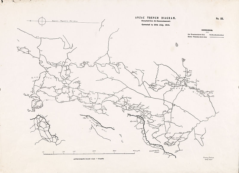
English: This map covers the area from Russell’s Top to Mortar Ridge, including Pope’s Hill, Baby 700, German Officer’s Trench and Quinn’s Post. It was compiled from air reconnaissances up to 20 July and shows the British front line and some communication trenches, as well as more extensive coverage of the Turkish trenches. It was printed by the Printing Section, General Headquarters, Mediterranean Expeditionary Force, located at Imbros. A copy of the ANZAC Trench Diagram No. III map was used to plan the attack on the Turkish positions at the Nek. The map is referred to in the Scheme and Detail of Attack in Operation Order No. 1. The Scheme and detail of Attack lists the objectives of each of the four lines attacking the Nek. On the map, the Turkish trenches are identified by letters and numbers, and these numbers are also given in the Operation Order. The trenches the 3rd Light Horse Brigade was to capture were up towards Baby 700 and across to the left of the Chessboard, a heavily entrenched Turkish position. Other parts of the Chessboard were to be captured by part of the 1st Light Horse Brigade. |
||||||||||||||||||||||
| Date | |||||||||||||||||||||||
| Source |
Australian War Memorial reference code: G7432.G1 S65 XII.8e url: http://www.awm.gov.au/exhibitions/gmaps/trench/nek/objectives.asp |
||||||||||||||||||||||
| Author | Printing Section, General Headquarters, Mediterranean Expeditionary Force | ||||||||||||||||||||||
| Permission (Reusing this file) |
|
||||||||||||||||||||||
File history
Click on a date/time to view the file as it appeared at that time.
| Date/Time | Thumbnail | Dimensions | User | Comment | |
|---|---|---|---|---|---|
| current | 13:38, 21 June 2011 |  | 4,724 × 3,432 (4.37 MB) | Labattblueboy (talk | contribs) | {{JPEG version of PNG|Battle of the Nek - map of objectives.png}} {{Information |Description={{en|This map covers the area from Russell’s Top to Mortar Ridge, including Pope’s Hill, Baby 700, German Officer’s Trench and Quinn’s Post. It was compil |
You cannot overwrite this file.
File usage on Commons
The following 2 pages use this file:
Metadata
This file contains additional information such as Exif metadata which may have been added by the digital camera, scanner, or software program used to create or digitize it. If the file has been modified from its original state, some details such as the timestamp may not fully reflect those of the original file. The timestamp is only as accurate as the clock in the camera, and it may be completely wrong.
| Orientation | Normal |
|---|---|
| Horizontal resolution | 72 dpi |
| Vertical resolution | 72 dpi |
