File:Beaufort Sea (MODIS 2016-08-17).jpg

Original file (6,400 × 5,000 pixels, file size: 6.71 MB, MIME type: image/jpeg)
Captions
Captions
Summary[edit]
.jpg&action=edit§ion=1)
| Description |
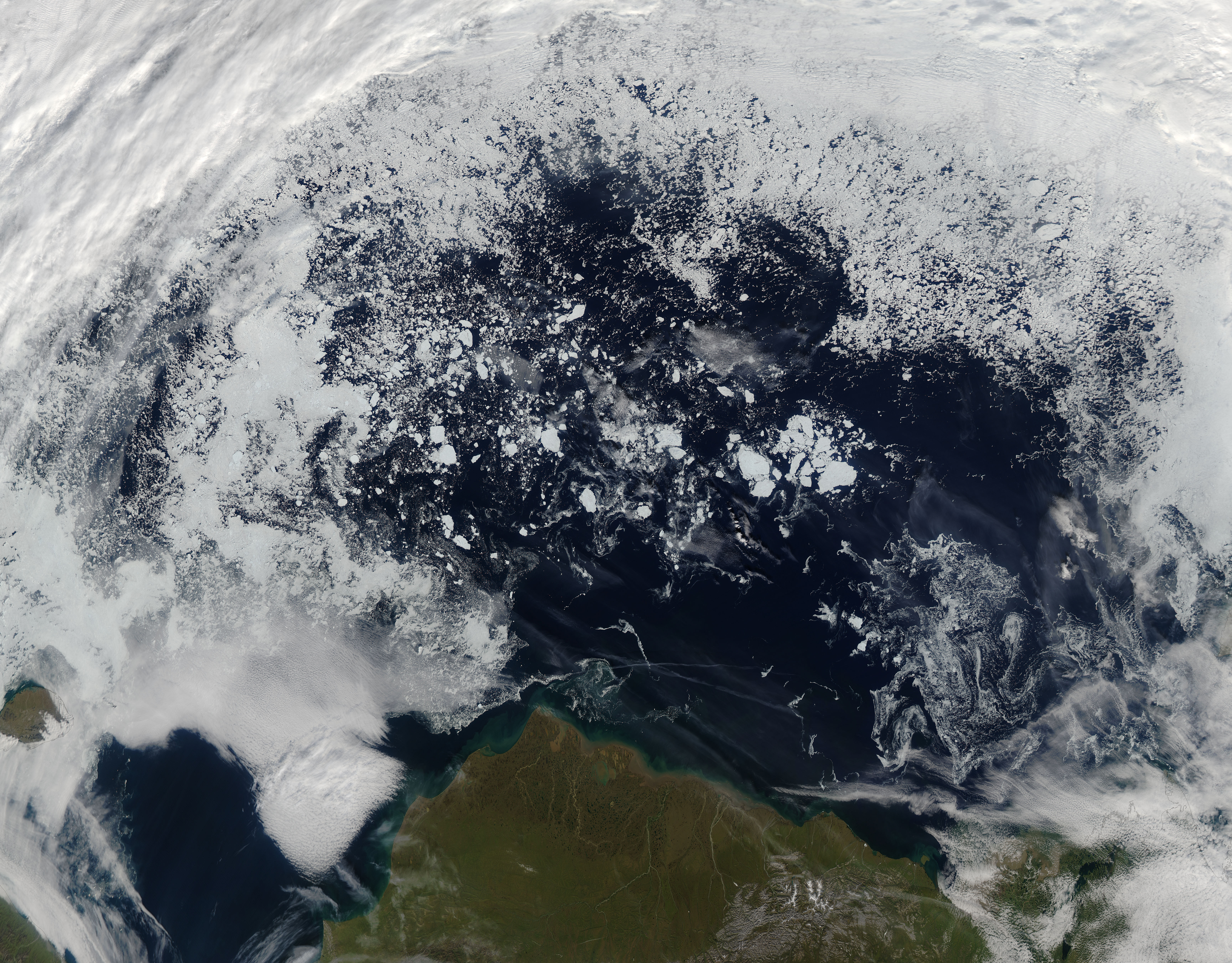
English: Sea ice melt in the Beaufort Sea started early in 2016, with significant fracturing and melting observed by mid-April, thanks to unusually warm temperatures during the first few months of the year. The melting and thinning of the expansive pack of sea ice that caps the Beaufort Sea during winter is an annual event, but normally it doesn’t begin in earnest until late May.
The unusually warm winter did not affect only the Beaufort Sea but also has had an impact on ice melt throughout the Arctic. According to the National Snow and Ice Data Center, as of August 14, Arctic sea ice extent is tracking third lowest in the satellite record, with the sea ice extent measured at 5.61 million square kilometers (2.17 million square miles). Ice loss has been particularly rapid in the Beaufort and Chukchi Seas where large ice floes have broken up and are beginning to melt away. It is hoped that some of the larger, multi-year ice floes will survive the summer, but that is not certain. Unusually warm water temperatures are likely to cause additional melting into September even though air temperatures are already beginning to drop as winter approaches. The early breakup of sea ice is considered to have aided in the warming of the waters because the open waters absorb much more heat from the warming rays of sunlight than when the water is covered by ice. On August 5, 2016, the Moderate Resolution Imaging Spectroradiometer (MODIS) aboard NASA’s Aqua satellite captured a true-color image of the Beaufort Sea north of Alaska. Banks of white clouds hang near the western and eastern shorelines and in the western and eastern edges of the image. Between the clouds, the blue waters of the Beaufort Sea are clearly visible, speckled with sea ice that appears almost foamy due to so much water being visible throughout the ice. A few filigrees of ice are also seen. It is interesting to compare this August 5, 2016, image with a MODIS image from August 1, 2006. The difference is dramatic: the sea ice in 2006 was much more extensive and thick, without any foamy appearance. In addition, a long section of ice remained very close to shore east of Barrow, Alaska. This image can be found at: https://earthobservatory.nasa.gov/IOTD/view.php?id=6797. Another interesting set of MODIS images was published by NASA’s Earth Observatory on May 20, 2016. These images compare sea ice in the Beaufort Sea throughout April 2014, 2015, and 2016 clearly illustrate the early breakup in 2016. This story can be found at: https://earthobservatory.nasa.gov/IOTD/view.php?id=88065. |
||
| Date | Taken on 5 August 2016 | ||
| Source |
|
||
| Author | Jeff Schmaltz, MODIS Land Rapid Response Team, NASA GSFC |
| This media is a product of the Aqua mission Credit and attribution belongs to the mission team, if not already specified in the "author" row |
Licensing[edit]
.jpg&action=edit§ion=2)
| This file is in the public domain in the United States because it was solely created by NASA. NASA copyright policy states that "NASA material is not protected by copyright unless noted". (See Template:PD-USGov, NASA copyright policy page or JPL Image Use Policy.) | ||
 |
Warnings:
|
File history
Click on a date/time to view the file as it appeared at that time.
| Date/Time | Thumbnail | Dimensions | User | Comment | |
|---|---|---|---|---|---|
| current | 19:23, 15 February 2024 | | 6,400 × 5,000 (6.71 MB) | OptimusPrimeBot (talk | contribs) | #Spacemedia - Upload of http://modis.gsfc.nasa.gov/gallery/images/image08172016_250m.jpg via Commons:Spacemedia |
You cannot overwrite this file.
File usage on Commons
There are no pages that use this file.
.jpg&oldid=852067851)