File:Blazes Continue to Scorch New Mexico (MODIS 2022-05-28).jpg

Original file (2,330 × 1,807 pixels, file size: 381 KB, MIME type: image/jpeg)
Captions
Captions
Summary
[edit].jpg&action=edit§ion=1)
| Description |
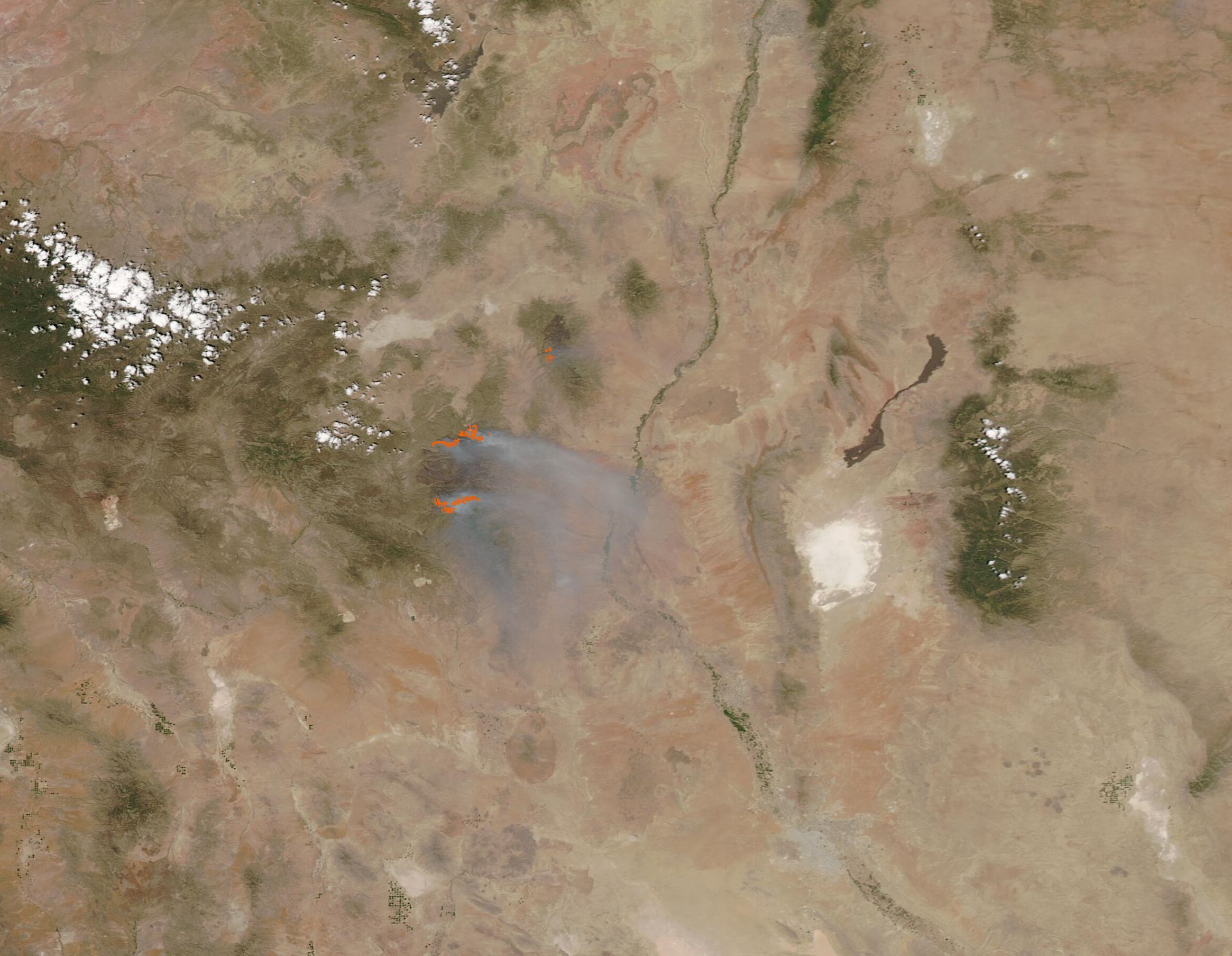
English: Fueled by high temperatures, low humidity, gusting winds, and a lingering two-decade megadrought, multiple large fires have more than a half-million acres in New Mexico as of May 27, 2022. A "Fuels and Fire Behavior Advisory" released by the National Interagency Fire Center on May 18 summed up the cause of the disastrous fire season this way, “expanding drought conditions coupled with very hot and dry weather, extreme wind events, and unstable atmospheric conditions have led to explosive fire behavior in the region.” In parts of Arizona and New Mexico, “conditions like this have not been seen since the mid-1950s.” The situation has not improved since that advisory. On May 19, the U.S. Drought Monitor reported that at least 85 percent of New Mexico was experiencing extreme to exceptional drought—and on May 26, an updated report stated that New Mexico received little or no precipitation in the last week.
On May 26, the Moderate Resolution Imaging Spectroradiometer (MODIS) on board NASA’s Aqua satellite acquired a true-color image of two fires burning in southwestern New Mexico. Each red “hot spot” marks an area where the thermal bands on the MODIS instrument detected high temperatures. In this case, the hot spots are caused by actively burning fire. A large blacked area (burn scar) can be seen in the lower section of the image, and two lines of active fire flank the burn scar. This is the Black Fire, which ignited on May 13 in the Aldo Leopold Wilderness Area about 30 miles northwest of Truth or Consequences, New Mexico. On May 16, the fire “blew up” – a term indicating a sudden increase in fire intensity or rate of spread—to triple in size. The Black Fire’s blow-up increased the size from 18,000 acres to more than 56,000 acres as it crossed the Continental Divide. On May 22, the Black Fire became the second-largest fire burning in New Mexico, covering 130,000 acres. By May 27, the acreage burnt increased to 191,459 and, according to a report on InciWeb Incident Information System, the fire was averaging an increase of 15,000 acres a day. Increasingly hot, dry, and breezy winds out of the west-southwest are expected to increase torching, spotting, and fire activity over the next few days, despite firefighters working day and night to suppress the extremely active fire. The National Interagency Fire Center notes that 51 structures are at risk, with 2 structures destroyed. The Black Fire was only 13 percent contained as of May 27. A smaller fire, the Bear Trap Fire, burns to the northeast of the Black Fire. This fire started on May 1, in timber located about 22 miles southwest of Magdalena, New Mexico. As of May 27, the fire scorched 38,091 Acres and was 41 percent contained. The cause of the fire is under investigation. |
||
| Date | Taken on 26 May 2022 | ||
| Source |
Blazes Continue to Scorch New Mexico (direct link)
|
||
| Author | MODIS Land Rapid Response Team, NASA GSFC |
| This media is a product of the Aqua mission Credit and attribution belongs to the mission team, if not already specified in the "author" row |
Licensing
[edit].jpg&action=edit§ion=2)
| This file is in the public domain in the United States because it was solely created by NASA. NASA copyright policy states that "NASA material is not protected by copyright unless noted". (See Template:PD-USGov, NASA copyright policy page or JPL Image Use Policy.) | ||
 |
Warnings:
|
File history
Click on a date/time to view the file as it appeared at that time.
| Date/Time | Thumbnail | Dimensions | User | Comment | |
|---|---|---|---|---|---|
| current | 22:03, 9 January 2024 | | 2,330 × 1,807 (381 KB) | OptimusPrimeBot (talk | contribs) | #Spacemedia - Upload of http://modis.gsfc.nasa.gov/gallery/images/image05282022_250m.jpg via Commons:Spacemedia |
You cannot overwrite this file.
File usage on Commons
There are no pages that use this file.
.jpg&oldid=840067201)