File:Bor District and Zaječar District (Timočka Krajina).jpg
Jump to navigation
Jump to search
No higher resolution available.
Bor_District_and_Zaječar_District_(Timočka_Krajina).jpg (402 × 576 pixels, file size: 87 KB, MIME type: image/jpeg)
Captions
Captions
Add a one-line explanation of what this file represents
Summary[edit]
.jpg&action=edit§ion=1)
| Description |
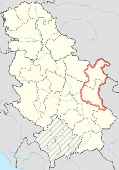
English: Map of Serbia with districts, with Timočka Krajina highlighted in red, that is Bor District and Zaječar District. The region has no official status; the extent to which "Timočka Krajina" extends is unclear, but within these two districts. |
| Date | |
| Source | File:Serbia adm location map.svg |
| Author | Zoupan (talk · contribs); map by NordNordWest (talk · contribs) |
Licensing[edit]
.jpg&action=edit§ion=2)
This file is licensed under the Creative Commons Attribution-Share Alike 3.0 Unported license.
- You are free:
- to share – to copy, distribute and transmit the work
- to remix – to adapt the work
- Under the following conditions:
- attribution – You must give appropriate credit, provide a link to the license, and indicate if changes were made. You may do so in any reasonable manner, but not in any way that suggests the licensor endorses you or your use.
- share alike – If you remix, transform, or build upon the material, you must distribute your contributions under the same or compatible license as the original.
File history
Click on a date/time to view the file as it appeared at that time.
| Date/Time | Thumbnail | Dimensions | User | Comment | |
|---|---|---|---|---|---|
| current | 00:54, 1 May 2015 | | 402 × 576 (87 KB) | Zoupan (talk | contribs) | removed excess space |
| 00:50, 1 May 2015 |  | 419 × 599 (83 KB) | Zoupan (talk | contribs) | User created page with UploadWizard |
You cannot overwrite this file.
File usage on Commons
The following page uses this file:
File usage on other wikis
The following other wikis use this file:
- Usage on ca.wikipedia.org
- Usage on en.wikipedia.org
- Usage on sr.wikipedia.org
- Usage on www.wikidata.org
.jpg&oldid=829395096)