File:Botswana (MODIS 2017-07-08).jpg

Original file (2,762 × 2,155 pixels, file size: 653 KB, MIME type: image/jpeg)
Captions
Captions
Summary
[edit].jpg&action=edit§ion=1)
| Description |
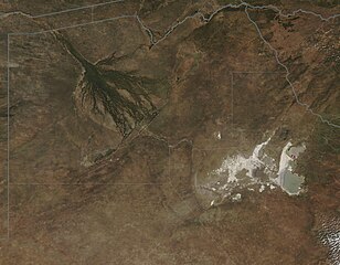
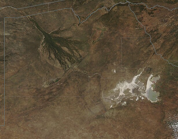
English: Botswana, a land-locked country in southern Africa, is slightly smaller than the state of Texas in size, encompassing about 224,607 square miles (581,730 square kilometers) of mostly arid land. The country is made up of primarily flat or rolling tableland, with the dry Kalahari Desert stretching over hundreds of miles in the southwest. The dryness of the country is also evidenced by the Makgadikgadi salt flats which appear white and gray on the tan plateau. These salt flats remain waterless and extremely arid in most years, but when rains are heavy, the salt flats may flood. When this occurs, wildlife and bird life becomes abundant. Spectacular displays of flamingo – tens of thousands at a time – can be drawn to the area in wet weather.
The majority of the water in Botswana can be found in the northwest section of the country, in the Okavango River Delta. This finger-like outpouring from the Okavango River creates permanent marshland and seasonally flooded plains. The wetlands are home to a wealth of animals, plants, and birds, but it when the Okavango River floods and drenches the plains during the dry season (May – October) that spectacular gatherings of wildlife surround the life-sustaining water. Because these floods occur on a regular basis in the dry winter season, the wildlife has adapted growth and reproductive behavior to be timed with the arrival of the floodwater. The Moderate Resolution Imaging Spectroradiometer (MODIS) aboard NASA’s Aqua satellite flew over Botswana on June 24, 2017 and acquired this true-color image of a sunny, dry, winter day. The finger-like tendrils of the inland Okavango Delta are clearly visible in the northwest. The Makgadikgadi salt flats, in the east, appear to hold a small amount of water. |
||
| Date | Taken on 24 June 2017 | ||
| Source |
|
||
| Author | Jeff Schmaltz, MODIS Land Rapid Response Team, NASA GSFC |
| This media is a product of the Aqua mission Credit and attribution belongs to the mission team, if not already specified in the "author" row |
Licensing
[edit].jpg&action=edit§ion=2)
| This file is in the public domain in the United States because it was solely created by NASA. NASA copyright policy states that "NASA material is not protected by copyright unless noted". (See Template:PD-USGov, NASA copyright policy page or JPL Image Use Policy.) | ||
 |
Warnings:
|
File history
Click on a date/time to view the file as it appeared at that time.
| Date/Time | Thumbnail | Dimensions | User | Comment | |
|---|---|---|---|---|---|
| current | 18:35, 16 February 2024 | | 2,762 × 2,155 (653 KB) | OptimusPrimeBot (talk | contribs) | #Spacemedia - Upload of http://modis.gsfc.nasa.gov/gallery/images/image07082017_250m.jpg via Commons:Spacemedia |
You cannot overwrite this file.
File usage on Commons
There are no pages that use this file.
.jpg&oldid=852522232)