File:Boulder batholith geologic map.jpg
Jump to navigation
Jump to search
Size of this preview: 480 × 599 pixels. Other resolutions: 192 × 240 pixels | 384 × 480 pixels | 689 × 860 pixels.
Original file (689 × 860 pixels, file size: 148 KB, MIME type: image/jpeg)
Captions
Captions
Boulder batholith geologic map
Summary
[edit]
| Description |
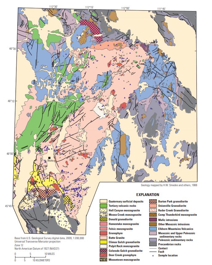
English: Boulder batholith geologic map |
| Date | |
| Source |
Synthesis of petrographic, geochemical, and isotopic data for the Boulder batholith, southwest Montana: U.S. Geological Survey Professional Paper 1793, https://pubs.usgs.gov/pp/1793/PP1793.pdf |
| Author | du Bray, E.A., Aleinikoff, J.N., and Lund, Karen |
Licensing
[edit]
This image is in the public domain in the United States because it only contains materials that originally came from the United States Geological Survey, an agency of the United States Department of the Interior. For more information, see the official USGS copyright policy.
|
File history
Click on a date/time to view the file as it appeared at that time.
| Date/Time | Thumbnail | Dimensions | User | Comment | |
|---|---|---|---|---|---|
| current | 10:53, 1 July 2020 | | 689 × 860 (148 KB) | Pi3.124 (talk | contribs) | Uploaded a work by du Bray, E.A., Aleinikoff, J.N., and Lund, Karen from Synthesis of petrographic, geochemical, and isotopic data for the Boulder batholith, southwest Montana: U.S. Geological Survey Professional Paper 1793, https://pubs.usgs.gov/pp/1793/PP1793.pdf with UploadWizard |
You cannot overwrite this file.
File usage on Commons
There are no pages that use this file.
File usage on other wikis
The following other wikis use this file:
- Usage on en.wikipedia.org
Metadata
Categories:
- Geological maps of Montana
- Mining in Montana
- Boulder Batholith
- Moose Creek Monzogranite
- Donald Granodiorite
- Homestake Monzogranite
- Butte Quartz Monzonite - maps
- Climax Gulch Granodiorite
- Pulpit Rock Monzogranite
- Colorado Gulch Granodiorite
- Denver Creek Granophyre
- Moosetown Monzogranite
- Burton Park Granodiorite
- Unionville Granodiorite
- Rader Creek Pluton
- Camp Thunderbird Monzogranite
- Quaternary deposits in Montana
- Hell Canyon Monzogranite
- Deer Creek Granophyre
- Mesozoic igneous intrusions in Montana