File:Brices Cross Roads, Tupelo LOC 2007627679.jpg
Jump to navigation
Jump to search

Size of this preview: 425 × 600 pixels. Other resolutions: 170 × 240 pixels | 340 × 480 pixels | 544 × 768 pixels | 726 × 1,024 pixels | 1,452 × 2,048 pixels | 5,025 × 7,089 pixels.
Original file (5,025 × 7,089 pixels, file size: 5.6 MB, MIME type: image/jpeg)
Captions
Captions
Add a one-line explanation of what this file represents
Summary[edit]
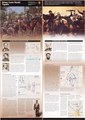
| Description |
English: "*GPO: 2006-320-369/00521 Reprint 2004." Title from panel. Includes text. Available also through the Library of Congress Web site as a raster image. |
||
| Title | Brices Cross Roads, Tupelo | ||
| Shelf ID | G3982.B7S1 2004 .U5 | ||
| Date | |||
| Source | https://www.loc.gov/item/2007627679/ | ||
| Author | United States. National Park Service | ||
| Permission (Reusing this file) |
|
||
| Other versions |
|
||
| Location | Brice'S Crossroads, Battle Of, Miss., 1864 · Tupelo, Battle Of, Tupelo, Miss., 1864 · Mississippi · Tupelo, Battle Of, Tupelo, Miss., 1864. · United States · Mississippi. · Brice'S Crossroads, Battle Of, Miss., 1864. | ||
| Part of | American Memory · General Maps · Catalog · Geography And Map Division | ||
| Subject | Campaigns · Mississippi · Tupelo, Battle Of, Tupelo, Miss. · Maps · Civil War · United States · Brice'S Crossroads, Battle Of, Miss. · History |

Licensing[edit]
| This image or media file contains material based on a work of a National Park Service employee, created as part of that person's official duties. As a work of the U.S. federal government, such work is in the public domain in the United States. See the NPS website and NPS copyright policy for more information. |
File history
Click on a date/time to view the file as it appeared at that time.
| Date/Time | Thumbnail | Dimensions | User | Comment | |
|---|---|---|---|---|---|
| current | 15:07, 29 November 2018 | | 5,025 × 7,089 (5.6 MB) | Fæ (talk | contribs) | LOC Maps https://www.loc.gov/item/2007627679/ #5274 |
You cannot overwrite this file.
File usage on Commons
The following page uses this file: