File:Byzantine Constantinople-el.svg
Jump to navigation
Jump to search

Size of this PNG preview of this SVG file: 662 × 600 pixels. Other resolutions: 265 × 240 pixels | 530 × 480 pixels | 848 × 768 pixels | 1,130 × 1,024 pixels | 2,261 × 2,048 pixels | 2,606 × 2,361 pixels.
Original file (SVG file, nominally 2,606 × 2,361 pixels, file size: 806 KB)
Captions
Captions
Add a one-line explanation of what this file represents
Summary
[edit]| Description |
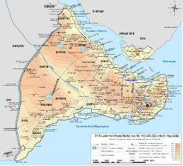
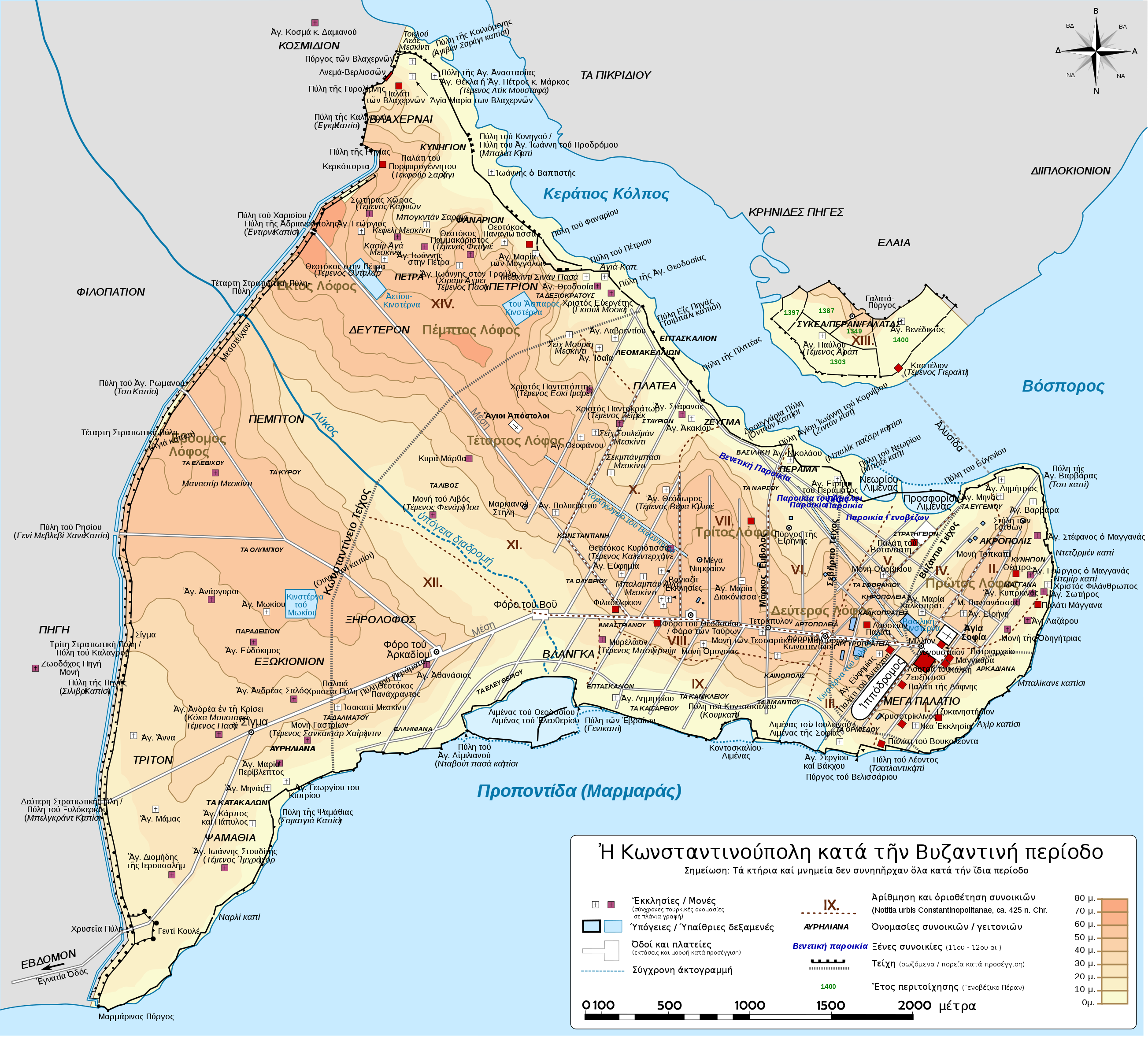
Deutsch: Topografische Karte Konstantinopels während des byzantinischen Zeitraums. Quelle: R. Janin, Constantinople Byzantine. Developpement urbain et repertoire topographique. Straßennetz und andere Einzelheiten basiert auf Dumbarton Oaks Papers 54. Kirchen, insb. nicht identifizierte und ausgegrabene Bauten sind aus dem The Byzantine Churches of Istanbul entnommen. Andere herausgegebenen Quellen wurden behilfsmäßig gebraucht. English: Topographical map of Constantinople (in Greek) during the Byzantine period. Main map source: R. Janin, Constantinople Byzantine. Developpement urbain et repertoire topographique. Road network and some other details based on Dumbarton Oaks Papers 54; data on many churches, especially unidentified ones, taken from the University of New York's The Byzantine Churches of Istanbul project. Other published maps and accounts of the city have been used for corroboration. Français : Carte en anglais de Constantinople à l'époque Byzantine. Source principale : R. Janin, Constantinople Byzantine. Développement urbain et répertoire topographique. Le réseau routier et d'autres détails proviennent de Dumbarton Oaks Papers 54. Les données concernant de nombreuses églises, en particulier celles non identifiées, viennent de l'université de New York : le projet The Byzantine Churches of Istanbul (Les églises byzantines d'Istanbul). D'autres cartes encore ont été utilisées pour recouper et vérifier les informations. Türkçe: Konstantinopolis'in Bizans dönemindeki topografik haritası. Ana haritanın kaynağı: R. Janin, Constantinople Byzantine. Developpement urbain et repertoire topographique. Yol haritası ve bazı diğer ayrıntıların kaynağı: Dumbarton Oaks Papers 54; kiliseler, özellikle kimliği belirlenmemiş olanlar hakkında veriler, New York University'nin İstanbul'un Bizans Kiliseleri projesinden elde edilmiştir. Şehir hakkında yayımlanmış diğer harita ve metinler bu bilgileri doğrulamak için kullanılmıştır. Ελληνικά: Τοπογραφικός χάρτης Κωνσταντινουπόλεως κατά τη Βυζαντινή περίοδο. Βασική πηγή χάρτη: R. Janin, Constantinople Byzantine. Developpement urbain et repertoire topographique. Το οδικό δίκτυο και διάφορες άλλες λεπτομέρειες με βάση το Dumbarton Oaks Papers 54. Πληροφορίες για τις εκκλησίες, ιδιαίτερα τις μη ταυτοποιημένες, από την ιστοσελίδα The Byzantine Churches of Istanbul του Πανεπιστημίου της Νέας Υόρκης. Беларуская: Мапа Канстанцінопаля часоў Візантыі. Беларуская (тарашкевіца): Мапа Канстантынопаля часоў Візантыі. Български: Топографска карта на Константинопол (Цариград) през византийския период. Източник: R. Janin, Constantinople Byzantine. Developpement urbain et repertoire topographique. Пътната мрежа и някои други детайли се основават на Dumbarton Oaks Papers 54 и други публикувани източници. Русский: Карта Константинополя времён Византии. Українська: Мапа Константинополя часів Візантії. |
| Date | |
| Source |
This file was derived from: Byzantine Constantinople-de.svg: |
| Author |
|
| Other versions |
[] Full maps[edit]SVG:
PNG:
Numeric versions[edit]
Regions[edit]
Roads[edit]
|


Licensing
[edit]
This file is licensed under the Creative Commons Attribution 3.0 Unported license.
- You are free:
- to share – to copy, distribute and transmit the work
- to remix – to adapt the work
- Under the following conditions:
- attribution – You must give appropriate credit, provide a link to the license, and indicate if changes were made. You may do so in any reasonable manner, but not in any way that suggests the licensor endorses you or your use.
File history
Click on a date/time to view the file as it appeared at that time.
| Date/Time | Thumbnail | Dimensions | User | Comment | |
|---|---|---|---|---|---|
| current | 17:10, 16 May 2016 | | 2,606 × 2,361 (806 KB) | Gts-tg (talk | contribs) | Typo fix |
| 11:44, 3 May 2016 |  | 2,606 × 2,361 (940 KB) | Gts-tg (talk | contribs) | Typo fix | |
| 11:40, 3 May 2016 |  | 2,606 × 2,361 (940 KB) | Gts-tg (talk | contribs) | Further positioning fixes | |
| 11:35, 3 May 2016 |  | 2,606 × 2,361 (943 KB) | Gts-tg (talk | contribs) | Positioning fixes | |
| 11:04, 3 May 2016 |  | 2,606 × 2,361 (948 KB) | Gts-tg (talk | contribs) | User created page with UploadWizard |
You cannot overwrite this file.
File usage on Commons
The following 18 pages use this file:
- User:J budissin/Uploads/BiH/2016 May 1-10
- User:J budissin/Uploads/BiH/2016 May 11-20
- User:Jaqeli/Georgia
- File:Byzantine Constantinople-de.svg
- File:Byzantine Constantinople-el.svg
- File:Byzantine Constantinople-en.png
- File:Byzantine Constantinople-en.svg
- File:Byzantine Constantinople-pt.svg
- File:Byzantine Constantinople-tr.png
- File:Byzantine Constantinople-tr.svg
- File:Byzantine Constantinople - ce.svg
- File:Byzantine Constantinople - ru.svg
- File:Byzantine Constantinople - uk.svg
- File:Byzantine Constantinople eu.png
- File:Byzantine Constantinople eu.svg
- File:Byzantine Constantinople regiones.svg
- File:Byzantine Constantinople viae.svg
- Template:Other versions/Byzantine Constantinople versions
File usage on other wikis
The following other wikis use this file:
- Usage on el.wikipedia.org
- Σεπτέμβριος
- Κωνσταντινούπολη
- Στάση του Νίκα
- Αγία Σοφία (Κωνσταντινούπολη)
- Άλωση της Κωνσταντινούπολης (1453)
- Τείχη της Κωνσταντινούπολης
- Σφαγή των Λατίνων
- Πολιορκία της Κωνσταντινούπολης (717-718)
- Πολιορκία της Κωνσταντινούπολης (674-678)
- Επτά λόφοι της Κωνσταντινούπολης
- Λύκος (ποταμός Κωνσταντινούπολης)
- Πολιορκία της Κωνσταντινούπολης (626)
- Φόρος του Βοός
- Κινστέρνα του Μωκίου
- Λιμένας του Ελευθερίου
- Πηγή (συνοικία)
- Φιλοπάτιον
- Κοσμίδιον
- Τα Διακονίσσης
- Βυζαντινή Κωνσταντινούπολη
- Πρότυπο:Χρονολόγιο βυζαντινής Κωνσταντινούπολης
- Κιστέρνα του Αετίου
- Κιστέρνα του Άσπαρος
- Μάγγανα (Κωνσταντινούπολη)
- Τα Αμαστριανού
- Κοντοσκάλιον
- Λιμένας των Νεωρίων
- Λιμένας του Προσφόριου
- Εξωκιόνιον
- Usage on es.wikipedia.org