File:Caminos Santiago actuales - 01 Camino Francés.svg
Jump to navigation
Jump to search

Size of this PNG preview of this SVG file: 776 × 375 pixels. Other resolutions: 320 × 155 pixels | 640 × 309 pixels | 1,024 × 495 pixels | 1,280 × 619 pixels | 2,560 × 1,237 pixels.
Original file (SVG file, nominally 776 × 375 pixels, file size: 562 KB)
Captions
Captions
Add a one-line explanation of what this file represents
Summary[edit]
| Description |
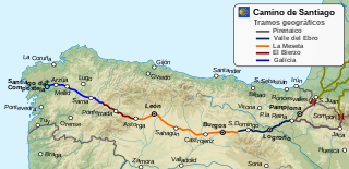
Español: Trazado del Camino de Santiago (camino francés)
Fuente: Federación Española de Asociaciones de Amigos del Camino de Santiago.
Polski: Przebieg Camino Frances |
| Date | |
| Source | Own work |
| Author | Paulusburg |
| SVG development |
Licensing[edit]
I, the copyright holder of this work, hereby publish it under the following license:
This file is licensed under the Creative Commons Attribution-Share Alike 4.0 International license.
- You are free:
- to share – to copy, distribute and transmit the work
- to remix – to adapt the work
- Under the following conditions:
- attribution – You must give appropriate credit, provide a link to the license, and indicate if changes were made. You may do so in any reasonable manner, but not in any way that suggests the licensor endorses you or your use.
- share alike – If you remix, transform, or build upon the material, you must distribute your contributions under the same or compatible license as the original.
File history
Click on a date/time to view the file as it appeared at that time.
| Date/Time | Thumbnail | Dimensions | User | Comment | |
|---|---|---|---|---|---|
| current | 02:00, 20 February 2022 | | 776 × 375 (562 KB) | Lojwe (talk | contribs) | Frame removed |
| 20:20, 7 March 2019 |  | 776 × 375 (566 KB) | Paulusburg (talk | contribs) | Separar el camino en tramos geográficos | |
| 16:29, 15 October 2018 |  | 776 × 375 (556 KB) | Paulusburg (talk | contribs) | Retoque en colores | |
| 08:45, 15 October 2018 |  | 793 × 375 (556 KB) | Paulusburg (talk | contribs) | Diferenciación de color con los caminos en Francia | |
| 08:33, 15 October 2018 |  | 793 × 375 (549 KB) | Paulusburg (talk | contribs) | User created page with UploadWizard |
You cannot overwrite this file.
File usage on Commons
The following 10 pages use this file:
- User:Adeletron 3030/botgalleries/Sports/2022 February 20-22
- User:Chumwa/OgreBot/Potential transport maps/2018 October 11-20
- User:Chumwa/OgreBot/Potential transport maps/2019 March 1-10
- User:Chumwa/OgreBot/Transport Maps/2018 October 11-20
- User:Chumwa/OgreBot/Transport Maps/2019 March 1-10
- User:Chumwa/OgreBot/Transport Maps/2022 February 19-28
- User:Chumwa/OgreBot/Travel and communication maps/2018 October 11-20
- User:Chumwa/OgreBot/Travel and communication maps/2019 March 1-10
- User:Chumwa/OgreBot/Travel and communication maps/2022 February 19-28
- Category:Camino de Santiago francés
File usage on other wikis
The following other wikis use this file:
- Usage on ca.wikipedia.org
- Usage on es.wikipedia.org
- Usage on fr.wikipedia.org
- Usage on it.wikipedia.org
- Usage on nl.wikipedia.org
- Usage on www.wikidata.org