File:Cape Cod Landsat 7.jpg
Jump to navigation
Jump to search

Size of this preview: 676 × 600 pixels. Other resolutions: 271 × 240 pixels | 541 × 480 pixels | 866 × 768 pixels | 1,154 × 1,024 pixels | 2,418 × 2,145 pixels.
Original file (2,418 × 2,145 pixels, file size: 1.07 MB, MIME type: image/jpeg)
Captions
Captions
Add a one-line explanation of what this file represents
| Description |
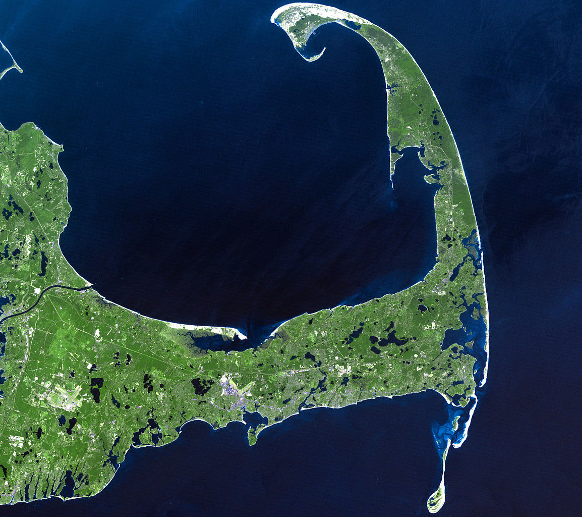
English: In easternmost Massachusetts, Cape Cod juts dramatically out into the Atlantic Ocean. The 65-mile peninsula has Cape Cod Bay to its north, the Nantucket Sound to its south and the Atlantic Ocean to its east. It is the world’s largest glacially formed peninsula; a remnant landscape left by the retreating Laurentide Ice Sheet.
The outer shore of the cape, from Long Point to south of Pleasant Bay, was designated as the Cape Cod National Seashore in August of 1961. The National Seashore encompasses over 44,000 acres of land, which includes marine, estuarine, and freshwater ecosystems. This Landsat 7 image was acquired on June 22, 2002. The pseudo-natural colour image, is a composite of ETM+ bands 7, 5, and 3. Cape Cod is found on Landsat WRS-2 Path 11 Row 31. |
| Date |
22 June 2002 |
| Source |
http://landsat.gsfc.nasa.gov/images/lg_jpg/f0006_06.22.02.jpg (http://landsat.gsfc.nasa.gov/images/archive/f0006.html) |
| Author |
NASA/Landsat 7. Original uploader was Ktr101 at en.wikipedia |
Licensing
[edit]
| This file is in the public domain in the United States because it was solely created by NASA. NASA copyright policy states that "NASA material is not protected by copyright unless noted". (See Template:PD-USGov, NASA copyright policy page or JPL Image Use Policy.) | ||
 |
Warnings:
|
This image is in the public domain in the United States because it only contains materials that originally came from the United States Geological Survey, an agency of the United States Department of the Interior. For more information, see the official USGS copyright policy.
|
Original upload log
[edit]
The original description page was here. All following user names refer to en.wikipedia.
- 2008-06-14 02:08 Ktr101 2418×2145× (1120814 bytes) Cape Cod from a Landsat 7 image in 2002. Source:http://landsat.gsfc.nasa.gov/images/archive/f0006.html
File history
Click on a date/time to view the file as it appeared at that time.
| Date/Time | Thumbnail | Dimensions | User | Comment | |
|---|---|---|---|---|---|
| current | 16:13, 9 August 2009 | | 2,418 × 2,145 (1.07 MB) | Transatracurium (talk | contribs) | {{Information |Description={{en| In easternmost Massachusetts, Cape Cod juts dramatically out into the Atlantic Ocean. The 65-mile peninsula has Cape Cod Bay to its north, the Nantucket Sound to its south and the Atlantic Ocean to its east. It is the worl |
You cannot overwrite this file.
File usage on Commons
The following page uses this file:
File usage on other wikis
The following other wikis use this file:
- Usage on ca.wikipedia.org
- Usage on de.wikipedia.org
- Usage on en.wikipedia.org
- Cape Cod
- User:Dchurbuck
- User:Cape cod naturalist
- User:Clariosophic
- User:Seduisant
- User:Quissett
- Attack on Orleans
- User:Lrsears
- Wikipedia:WikiProject Cape Cod and the Islands
- Template:User WikiProject Cape Cod and the Islands
- File talk:Cape Cod Landsat 7.jpg
- User:Ktr101/Userboxes
- User:Grolltech
- User:Happyandrew1994
- Wikipedia:Userboxes/WikiProjects/Regional/03
- Shields (album)
- Wikipedia:Userboxes/WikiProjects/alphabetical/06
- Category:Wikipedians interested in Cape Cod and the Islands
- User:M V D H P
- Usage on he.wikipedia.org
- Usage on mk.wikipedia.org
- Usage on sk.wikipedia.org
- Usage on sr.wikipedia.org
- Usage on www.wikidata.org