File:Captaincy General of Chile (orthographic projection).svg
Jump to navigation
Jump to search

Size of this PNG preview of this SVG file: 550 × 550 pixels. Other resolutions: 240 × 240 pixels | 480 × 480 pixels | 768 × 768 pixels | 1,024 × 1,024 pixels | 2,048 × 2,048 pixels.
Original file (SVG file, nominally 550 × 550 pixels, file size: 844 KB)
Captions
Captions
Add a one-line explanation of what this file represents
Summary[edit]
| Description |
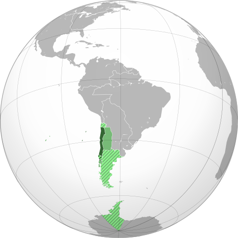
English: Approximate extension of the Captaincy General of Chile in orthographic projection.
Territory under efective control of the Captaincy by 1786. Territory of the Captaincy, ceded or transfered before 1786. Claimed, disputed, not under effective control or only nominal control territory asociated to the Captaincy by 1786. Claimed, disputed, not under effective control or only nominal control territory associated with ceded territories of the Captaincy. Español: Ubicación geográfica aproximada de la Capitanía General de Chile en proyección ortográfica.
Territorio efectivo de la Capitanía hacia 1786. Territorio de la Capitanía, cedido o transferido a otras entidades previo a 1786. Territorio reclamado, disputado, sin control efectivo o sólo control nominal asociado a la Capitanía hacia 1786. Territorio reclamado, disputado, sin control efectivo o sólo control nominal asociado a territorios cedidos por la Capitanía. |
||
| Date | |||
| Source |
Own work based on: the Brazil (orthographic projection).svg, created by the Wikimedia Commons user Ssolbergj, under a Creative Commons Licence. Boundaries based in the following sources:
|
||
| Author | B1mbo | ||
| Permission (Reusing this file) |
I, the copyright holder of this work, hereby publish it under the following license: This file is licensed under the Creative Commons Attribution 3.0 Unported license.
|
||
| Other versions |
.svg)
|
||
| SVG development |
.svg)
.svg)
.svg)
.svg)
.svg)
.svg)
.svg)
.svg)
.svg)
.svg)
.svg)
.svg)
.svg)
.svg)
.svg)
.svg)
.svg)
.svg)
.svg)
.svg)
.svg)
.svg)
.svg)
.svg)
.svg)
.svg)
.svg)
.svg)
.svg)
.svg)
.svg)
.svg)
.svg)
.svg)
.svg)
.svg)
.svg)
.svg)
.svg)
.svg)
.svg)
.svg)
.svg)
.svg)
.svg)
.svg)
.svg)
.svg)
.svg)
.svg)
.svg)
.svg)
.svg)
.svg)
.svg)
.svg)
.svg)
.svg)
.svg)
.svg)
.svg)
.svg)
.svg)
.svg)
.svg)
.svg)
.svg)
.svg)
.svg)
.svg)
.svg)
.svg)
.svg)

.svg)

.svg)

.svg)
.svg)
.svg)
.svg)
.svg)
.svg)
.svg)


.svg)
.svg)
.svg)
.svg)
.svg)
.svg)
.svg)

.svg)
.svg)
.svg)
.svg)
.svg)
.svg)
.svg)
.svg)
.svg)
.svg)

.svg)
.svg)
.svg)
.svg)
.svg)
.svg)
.svg)
_without_national_boundaries.svg)
.svg)
.svg)
.svg)
.svg)
.svg)
.svg)

.svg)
.svg)
.png)
.svg)
.svg)
.svg)
.svg)

.svg)
.svg)
.svg)
.svg)
.svg)
.svg)
.svg)
.svg)
.svg)
.svg)
.svg)

.svg)
.svg)
.svg)
.svg)
.svg)
.svg)
.svg)
.svg)
.svg)

.svg)
.svg)

.svg)
.svg)
.svg)
.svg)
.svg)
.svg)
.svg)
.svg)
.svg)
.svg)
.svg)
.svg)
.svg)
.svg)
.svg)
.svg)
.svg)
.svg)
.svg)
.svg)
.svg)
.svg)
.svg)
.svg)
.svg)
.svg)
.svg)
_-_Crimea_disputed.svg)
.svg)
.svg)
.svg)
.svg)
.svg)
.svg)
.svg)
.svg)
.svg)
.svg)
.svg)
_political.svg)
.svg)
.svg)
.svg)
.svg)
_-_Crimea_disputed_-_no_borders.svg)
.svg)
.svg)
.svg)
.svg)
.svg)
.svg)
.svg)
.svg)
.svg)
.svg)
.svg)

.svg)
.svg)
.svg)

.png)
.svg)
.svg)
.svg)
.svg)
.svg)
.svg)
.svg)
.svg)
.svg)
.svg)
.svg)
.svg)
.svg)
.svg)
.svg)
.svg)
.svg)
.svg)
.svg)
.svg)
.svg)
.svg)
.svg)
.svg)
.svg)
.svg)
.svg)
.svg)
.svg)
.svg)
.svg)
.svg)
.svg)
.svg)
.png)
.svg)
.svg)
.svg)
_(orthographic_projection).png)

.svg&action=edit§ion=1)
.svg)
.jpg)
.svg)
File history
Click on a date/time to view the file as it appeared at that time.
| Date/Time | Thumbnail | Dimensions | User | Comment | |
|---|---|---|---|---|---|
| current | 19:36, 7 November 2022 | | 550 × 550 (844 KB) | Janitoalevic (talk | contribs) | Borders bases on the Map of Cano y Olmedilla of 1775 |
| 16:54, 18 October 2022 |  | 550 × 550 (373 KB) | Janitoalevic (talk | contribs) | Added Terra Australis (1555) and Easter Island (1770) | |
| 22:37, 7 July 2022 |  | 550 × 550 (364 KB) | Janitoalevic (talk | contribs) | límite en el río Loa entre la prov. de Santiago y Arequipa (Eyzaguirre, Jaime, 1967) | |
| 22:11, 19 September 2019 |  | 550 × 550 (253 KB) | B1mbo (talk | contribs) | Correcciones | |
| 17:00, 10 July 2012 |  | 550 × 550 (139 KB) | Jespinos (talk | contribs) | Reverted to version as of 16:58, 10 July 2012 | |
| 16:58, 10 July 2012 |  | 550 × 550 (150 KB) | Jespinos (talk | contribs) | Reverted to version as of 09:07, 26 May 2012 | |
| 16:58, 10 July 2012 |  | 550 × 550 (139 KB) | Jespinos (talk | contribs) | Reverted to version as of 23:27, 20 June 2010 | |
| 09:07, 26 May 2012 |  | 550 × 550 (150 KB) | Franco-eisenhower (talk | contribs) | Límite verdadero Patagonia: http://www.scielo.cl/scielo.php?pid=S0717-71942002003500009&script=sci_arttext&tlng=es | |
| 23:27, 20 June 2010 |  | 550 × 550 (139 KB) | B1mbo (talk | contribs) | == Summary == {{created with Inkscape}} {{Information |Description= {{en|Location of the Captaincy General of Chile in orthographic projection, approx. 1796. {{legend|DarkGreen|Sovereign territory.}} {{legend|Lime|Terr |
You cannot overwrite this file.
File usage on Commons
More than 100 pages use this file. The following list shows the first 100 pages that use this file only. A full list is available.
.svg)
- Grey–green orthographic projections maps
- User:Heraldry/Projections
- User:Ssolbergj/orthographic
- File:ALBA (orthographic projection).png
- File:Africa (orthographic projection).svg
- File:African Union (orthographic projection).svg
- File:Almoravid map.svg
- File:America do Sul (orthographic projection).jpg
- File:Americas (orthographic projection).svg
- File:Andean Community (orthographic projection).svg
- File:Antarctica (orthographic projection).svg
- File:Antillas (orthographic projection).svg
- File:Arctic (orthographic projection).svg
- File:Argentina (orthographic projection).png
- File:Argentina (orthographic projection).svg
- File:Aridoamerica (orthographic projection).svg
- File:Armenia (orthographic projection).svg
- File:Asia (orthographic projection).svg
- File:Association of Southeast Asian Nations (orthographic projection).svg
- File:Australia-New Guinea (orthographic projection).svg
- File:Australia (orthographic projection).svg
- File:Australia map with outlying islands.svg
- File:Bhutan (orthographic projection).svg
- File:Brazil (orthographic projection).svg
- File:CECAFA-Map.svg
- File:Canada (orthographic projection).svg
- File:Cape Verde (orthographic projection).svg
- File:Captaincy General of Chile (orthographic projection).svg
- File:Central America (orthographic projection).svg
- File:Central Asia (orthographic projection).svg
- File:Chile (orthographic projection).svg
- File:Colombia (orthographic projection).svg
- File:Democratic Republic of the Congo (orthographic projection).svg
- File:Dominion of Pakistan & Indian Controlled Kashmir (orthographic projection).svg
- File:East Asia (orthographic projection).svg
- File:Ecuador (orthographic projection).svg
- File:Europe (orthographic projection).svg
- File:European Union (orthographic projection).svg
- File:Federal Republic of Central America (orthographic projection).svg
- File:First Brazilian Empire (orthographic projection).svg
- File:First Mexican Empire (orthographic projection).svg
- File:Georgia (orthographic projection).svg
- File:Germany (orthographic projection).svg
- File:Global European Union.svg
- File:Great Colombia (orthographic projection).svg
- File:Greater Middle East (orthographic projection).svg
- File:Haiti (orthographic projection).svg
- File:India (orthographic projection).svg
- File:Indonesia (orthographic projection).svg
- File:Iran (orthographic projection).svg
- File:Iraq (orthographic projection).svg
- File:Jamaica (orthographic projection).svg
- File:Japan (orthographic projection).svg
- File:Kazakhstan (orthographic projection).svg
- File:Latin America (orthographic projection).svg
- File:Lusophone America (orthographic projection).svg
- File:MERCOSUR (orthographic projection).svg
- File:Madagascar (orthographic projection).svg
- File:Maghreb (orthographic projection).svg
- File:Malaysia (orthographic projection).svg
- File:Mayan languages (orthographic projection).svg
- File:Mesoamerica (orthographic projection) with borders.svg
- File:Mexico (orthographic projection).svg
- File:Mexico and Central America (orthographic projection).svg
- File:Middle East (orthographic projection).svg
- File:Mongolia (orthographic projection).svg
- File:New Spain (orthographic projection).svg
- File:New Zealand (orthographic projection).svg
- File:Nigeria (orthographic projection).svg
- File:North Africa (orthographic projection).svg
- File:North America (orthographic projection).svg
- File:North American Agreement (orthographic projection).svg
- File:North Korea (orthographic projection).svg
- File:Papua New Guinea (orthographic projection).svg
- File:Paraguay (orthographic projection).svg
- File:People's Republic of China (orthographic projection).svg
- File:Peru (orthographic projection).svg
- File:Peru–Bolivia Confederation (orthographic projection).svg
- File:Philippines (orthographic projection).svg
- File:Republic of Artsakh (orthographic projection).svg
- File:Republic of China (orthographic projection).svg
- File:Rio Group (orthographic projection).svg
- File:Roman Empire (orthographic projection).svg
- File:Russian Federation (orthographic projection).svg
- File:Second Mexican Empire (orthographic projection).svg
- File:South Asia (orthographic projection) without national boundaries.svg
- File:South Korea (orthographic projection).svg
- File:Southern Europe (orthographic projection).svg
- File:Tawantinsuyu (orthographic projection).svg
- File:The Philippines and ASEAN (orthographic projection).svg
- File:Third Reich (orthographic projection).svg
- File:Tunisia (orthographic projection).svg
- File:Turkey (orthographic projection).svg
- File:Union of South American Nations (orthographic projection).svg
- File:Union of Soviet Socialist Republics (orthographic projection).svg
- File:United Provinces of Central America (orthographic projection).svg
- File:Venezuela (orthographic projection).svg
- File:Viceroyalty of Peru (orthographic projection).svg
- File:Viceroyalty of the Río de la Plata (orthographic projection).svg
- File:Wilsonian Armenia (orthographic projection).svg
.png)
.svg)
.jpg)
.svg)
.svg)
.png)
.svg)
.svg)
.svg)
.svg)
.svg)
.svg)
.svg)
_with_borders.svg)
.svg)
.svg)
.svg)
.svg)
.svg)
.svg)
View more links to this file.
File usage on other wikis
The following other wikis use this file:
- Usage on ar.wikipedia.org
- Usage on ca.wikipedia.org
- Usage on cs.wikipedia.org
- Usage on en.wikipedia.org
- Usage on es.wikipedia.org
- Usage on eu.wikipedia.org
- Usage on fr.wikipedia.org
- Usage on he.wikipedia.org
- Usage on it.wikipedia.org
- Usage on lt.wikipedia.org
- Usage on pt.wikipedia.org
- Usage on ru.wikipedia.org
- Usage on sv.wikipedia.org
- Usage on th.wikipedia.org
- Usage on uk.wikipedia.org
- Usage on www.wikidata.org
- Usage on zh.wikipedia.org
.svg&oldid=848047841)