File:Carta náutica de 1926 de la ría del Astillero (Cantabria).pdf
Jump to navigation
Jump to search

Size of this JPG preview of this PDF file: 452 × 599 pixels. Other resolutions: 181 × 240 pixels | 362 × 480 pixels | 579 × 768 pixels | 772 × 1,024 pixels | 1,545 × 2,048 pixels | 6,766 × 8,968 pixels.
Original file (6,766 × 8,968 pixels, file size: 1.56 MB, MIME type: application/pdf)
Captions
Captions
Add a one-line explanation of what this file represents
Summary
[edit]| Description |
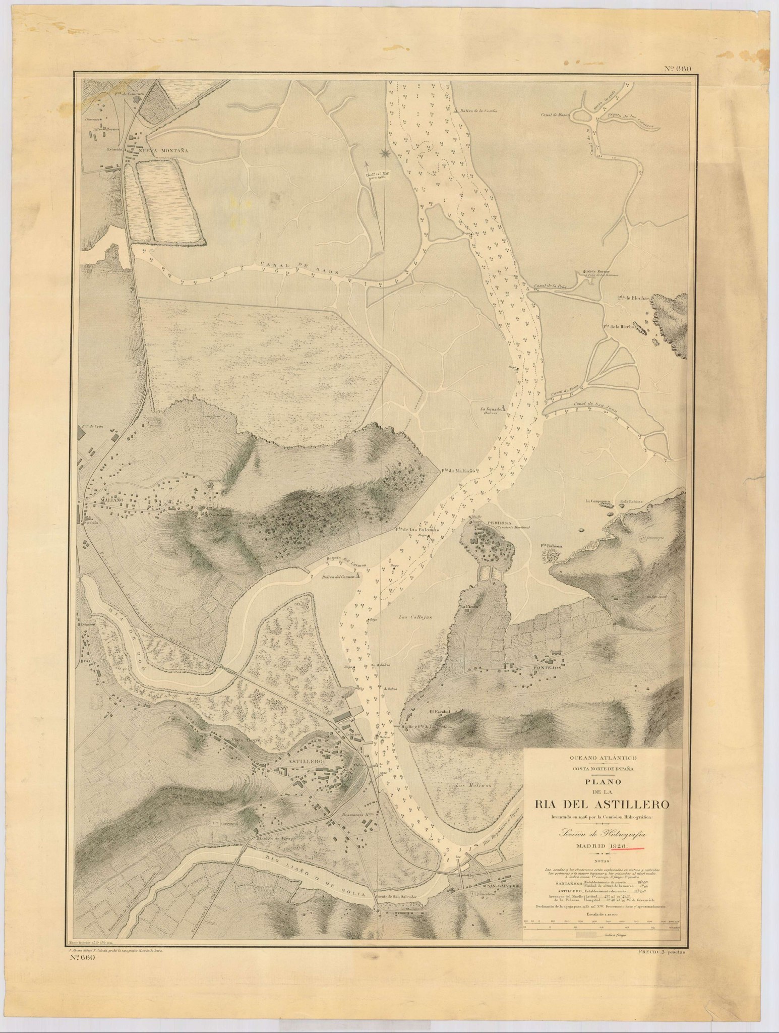
Español: Plano de la Ria del Astillero / levantado en 1926 por la Comision Hidrográfica ; J. Alzina dibujó ; F. Galván grabó la Topografia ; M. Ocón la letra. Escala 1:10000.
Orientado al N. y N. magnético Relieve representado por normales Indica sondas batimétricas, veriles y calidad de fondos Notas: "Las sondas y las elevaciones están expresadas en metros. "La Variación de la aguja para 1935: 12 N.W., decremiento ánuo 7' aproximadamente" Localización geográfica del arranque del muelle de la Pedrosa, según el meridiano de Greenwich En el ángulo inferior izquierdo: "Precio 3 pesetas" |
| Date | |
| Source | http://bibliotecavirtualdefensa.es/BVMDefensa/es/catalogo_imagenes/grupo.do?path=219697&presentacion=pagina&posicion=1®istrardownload=0 |
| Author |
Comisión Hidrográfica de España Dirección General de Navegación y Pesca Marítima de España, Sección de Hidrografía J. Alzina dibujó; F. Galván grabó la topografia; M. Ocón la letra |
Licensing
[edit]This file is licensed under the Creative Commons Attribution-Share Alike 4.0 International license.
- You are free:
- to share – to copy, distribute and transmit the work
- to remix – to adapt the work
- Under the following conditions:
- attribution – You must give appropriate credit, provide a link to the license, and indicate if changes were made. You may do so in any reasonable manner, but not in any way that suggests the licensor endorses you or your use.
- share alike – If you remix, transform, or build upon the material, you must distribute your contributions under the same or compatible license as the original.
File history
Click on a date/time to view the file as it appeared at that time.
| Date/Time | Thumbnail | Dimensions | User | Comment | |
|---|---|---|---|---|---|
| current | 09:50, 2 August 2021 |  | 6,766 × 8,968 (1.56 MB) | LMLM (talk | contribs) | Uploaded a work by Comisión Hidrográfica de España Dirección General de Navegación y Pesca Marítima de España, Sección de Hidrografía J. Alzina dibujó; F. Galván grabó la topografia; M. Ocón la letra from http://bibliotecavirtualdefensa.es/BVMDefensa/es/catalogo_imagenes/grupo.do?path=219697&presentacion=pagina&posicion=1®istrardownload=0 with UploadWizard |
You cannot overwrite this file.
File usage on Commons
The following page uses this file: