File:Caucasus-political nl.svg
Jump to navigation
Jump to search

Size of this PNG preview of this SVG file: 632 × 599 pixels. Other resolutions: 253 × 240 pixels | 506 × 480 pixels | 810 × 768 pixels | 1,080 × 1,024 pixels | 2,159 × 2,048 pixels | 972 × 922 pixels.
Original file (SVG file, nominally 972 × 922 pixels, file size: 383 KB)
Captions
Captions
Add a one-line explanation of what this file represents
Summary[edit]
| Description |
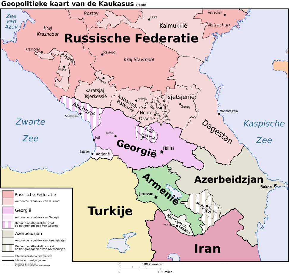
Nederlands: Geopolitieke kaart van de Kaukasus. |
| Date | 02/09/08 |
| Source |
Nederlands: Grootste deel van de grenzen gebaseerd op Image:Caucasus-ethnic en.svg door User:Pmx, wat weer een vectorisatie is van deze CIA kaart. Oude (autonome oblast) en huidige (de facto onafhankelijke republiek) grenzen van Nagorno Karabach overgetrokken van Location_Nagorno-Karabakh_en.png. Noordkust van Turkije overgetrokken van Map_of_Turkey_(2007).gif. |
| Author | Jeroencommons |
| Permission (Reusing this file) |
GFDL && CC-BY |
| Other versions |
[]
|


.png)


.gif)

|
This SVG file contains embedded text that can be translated into your language, using any capable SVG editor, text editor or the SVG Translate tool. For more information see: About translating SVG files. |
This W3C-unspecified vector image was created with Inkscape .
Licensing[edit]
Jeroenscommons, the copyright holder of this work, hereby publishes it under the following licenses:

|
Permission is granted to copy, distribute and/or modify this document under the terms of the GNU Free Documentation License, Version 1.2 or any later version published by the Free Software Foundation; with no Invariant Sections, no Front-Cover Texts, and no Back-Cover Texts. A copy of the license is included in the section entitled GNU Free Documentation License. |
| This file is licensed under the Creative Commons Attribution-Share Alike 3.0 Unported license. | ||
| Attribution: Jeroenscommons | ||
| ||
| This licensing tag was added to this file as part of the GFDL licensing update. |
This file is licensed under the Creative Commons Attribution 2.5 Generic license.
Attribution: Jeroenscommons
- You are free:
- to share – to copy, distribute and transmit the work
- to remix – to adapt the work
- Under the following conditions:
- attribution – You must give appropriate credit, provide a link to the license, and indicate if changes were made. You may do so in any reasonable manner, but not in any way that suggests the licensor endorses you or your use.
You may select the license of your choice.
File history
Click on a date/time to view the file as it appeared at that time.
| Date/Time | Thumbnail | Dimensions | User | Comment | |
|---|---|---|---|---|---|
| current | 10:44, 20 January 2020 | | 972 × 922 (383 KB) | Takhirgeran Umar (talk | contribs) | clarification |
| 05:00, 27 April 2018 |  | 972 × 922 (368 KB) | Kentronhayastan (talk | contribs) | Updated "Nagorno-Karabakh" to "Artsakh," the new official name of the self-proclaimed republic. | |
| 23:38, 12 March 2010 |  | 972 × 922 (368 KB) | Jeroen (talk | contribs) | Nagorno Karabach vervangen met Nagorno-Karabach (naar: http://taaladvies.net/taal/aardrijkskundige_namen/wijzigingen/) | |
| 00:50, 2 September 2008 |  | 972 × 922 (368 KB) | Jeroen (talk | contribs) | 2008 | |
| 00:12, 2 September 2008 |  | 972 × 922 (368 KB) | Jeroen (talk | contribs) | ||
| 00:01, 2 September 2008 |  | 972 × 922 (368 KB) | Jeroen (talk | contribs) | ||
| 23:58, 1 September 2008 |  | 972 × 922 (365 KB) | Jeroen (talk | contribs) | ||
| 23:51, 1 September 2008 |  | 972 × 922 (362 KB) | Jeroen (talk | contribs) | == Description == {{Information |Description={{nl|Geopolitieke kaart van de Kaukasus.}} |Source=Grootste deel van de grenzen gebasseerd op Image:Caucasus-ethnic en.svg door User:Pmx, wat weer |
You cannot overwrite this file.
File usage on Commons
The following 22 pages use this file:
- File:Caucasus-political-fr.svg
- File:Caucasus-political-krc.svg
- File:Caucasus-political-ru.svg
- File:Caucasus-political-tr.svg
- File:Caucasus-political (hy).png
- File:Caucasus-political Fa.svg
- File:Caucasus-political ca.svg
- File:Caucasus-political cs.svg
- File:Caucasus-political de.svg
- File:Caucasus-political en.svg
- File:Caucasus-political es.svg
- File:Caucasus-political ja.svg
- File:Caucasus-political mk.svg
- File:Caucasus-political mzn.svg
- File:Caucasus-political nl.svg
- File:Caucasus-political pl.svg
- File:Caucasus-political pt.svg
- File:Caucasus-political vi.svg
- File:Kaukasian geopoliittinen kartta.svg
- File:Kaukasus politiek.png
- File:Republics of the North Caucasus.png
- Template:Other versions/Caucasus-political
File usage on other wikis
The following other wikis use this file:
- Usage on af.wikipedia.org
- Usage on fy.wikipedia.org
- Usage on hy.wikipedia.org
- Usage on li.wikipedia.org
- Usage on nl.wikipedia.org
- Usage on tr.wikipedia.org