File:Charta öfwer södra delen af Swerige - Kungliga Biblioteket - 10294581.tif
Jump to navigation
Jump to search

Size of this JPG preview of this TIF file: 479 × 600 pixels. Other resolutions: 192 × 240 pixels | 383 × 480 pixels | 613 × 768 pixels | 818 × 1,024 pixels | 1,635 × 2,048 pixels | 9,344 × 11,702 pixels.

Original file (9,344 × 11,702 pixels, file size: 625.7 MB, MIME type: image/tiff, 2 pages)
Captions
Captions
Add a one-line explanation of what this file represents
| Warning | The original file is very high-resolution. It might not load properly or could cause your browser to freeze when opened at full size. |
|---|
| Title |
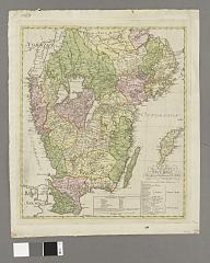
Charta öfwer södra delen af Swerige |
||||||||||||||||||||||||||
| Description |
Svenska: Länsgränser. - Städer, kungliga slott, kyrkor, säterier, gästgiverier och vägar utsatta. - Med förteckning över län och landskap. - Teckenförklaring |
||||||||||||||||||||||||||
| Source |
|
||||||||||||||||||||||||||
| Creator |
|
||||||||||||||||||||||||||
| Permission (Reusing this file) |
Per the source the digitisations are under
|
||||||||||||||||||||||||||
| Geotemporal data | |||||||||||||||||||||||||||
| Scale | 1:1,100,000 | ||||||||||||||||||||||||||
| Bounding box |
|
||||||||||||||||||||||||||
| Georeferencing | If inappropriate please set warp_status = skip to hide. | ||||||||||||||||||||||||||
| Bibliographic data | |||||||||||||||||||||||||||
| Map sheet | 1 karta | ||||||||||||||||||||||||||
| Language | Swedish | ||||||||||||||||||||||||||
| Publisher |
Unknown, Stockholm, Sweden |
||||||||||||||||||||||||||
| Archival data | |||||||||||||||||||||||||||
| Collection |
|
||||||||||||||||||||||||||
| Accession number |
10294581 |
||||||||||||||||||||||||||
| Dimensions | plåt 59 x 50 cm | ||||||||||||||||||||||||||
| Medium | kopparstick | ||||||||||||||||||||||||||
| Notes |
Hans kongl. maj:t konung Gustaf III i underdånighet tilägnad af Nils Marelius ; graverad af C. Bergqvist och F. Akrel
|
||||||||||||||||||||||||||
| Other versions |
 |
||||||||||||||||||||||||||

File history
Click on a date/time to view the file as it appeared at that time.
| Date/Time | Thumbnail | Dimensions | User | Comment | |
|---|---|---|---|---|---|
| current | 19:28, 20 January 2015 |  | 9,344 × 11,702, 2 pages (625.7 MB) | L PBot (talk | contribs) | {{subst:User:André_Costa_(WMSE)/KB-map |title = Charta öfwer södra delen af Swerige |description = {{sv|Länsgränser. - Städer, kungliga slott, kyrkor, säterier, gästgiverier och vägar utsatta. - Med förteckning över län och... |
You cannot overwrite this file.
File usage on Commons
The following 5 pages use this file: