File:Color around Hainan Island, China (MODIS 2021-12-04).jpg
Jump to navigation
Jump to search

Size of this preview: 740 × 600 pixels. Other resolutions: 296 × 240 pixels | 592 × 480 pixels | 947 × 768 pixels | 1,263 × 1,024 pixels | 2,484 × 2,014 pixels.
Original file (2,484 × 2,014 pixels, file size: 414 KB, MIME type: image/jpeg)
Captions
Captions
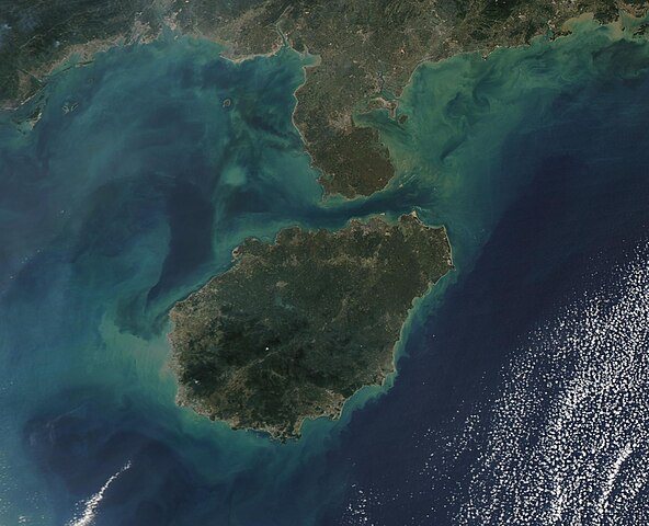
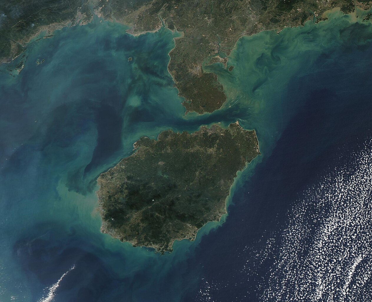
On December 3, 2021, the Moderate Resolution Imaging Spectroradiometer (MODIS) on board NASA’s Aqua satellite acquired a true-color image of Hainan Island.
Summary[edit]
.jpg&action=edit§ion=1)
| Description |
English: Hainan Island has been called “China’s largest tropical island”, thanks to its wealth of warm weather and sandy beaches. Sitting south of Guangdong Province on China’s mainland, Hainan Island measures about 12,700 square miles (32,900 square km) and is the largest island in Hainan Province. The province itself is made up of about 200 small islands, which make up only about 3 percent of the land mass. Hainan Island encompasses the other 97 percent.
On December 3, 2021, the Moderate Resolution Imaging Spectroradiometer (MODIS) on board NASA’s Aqua satellite acquired a true-color image of Hainan Island. To the north, the island is separated from the Leizhou Peninsula by the Qiongzhou Strait. The waters of the South China Sea surround the rest of Hainan. Dramatic swirls of tans, greens, and blues stain the waters off the southern coast of the mainland and off of Hainan Island. The color appears to come primarily from sediment, which has been washed into the South China Sea from the land or spilled into it from the many rivers that feed into the Sea. Sediment appears a muddy tan when it floats at the surface, most typically near shorelines, which can be seen in this image. As sediment sinks and disperses, the reflectivity changes so the color as seen from above also changes, first to green and then to shades of blue. It is possible that some color may also come from blooms of floating, plant-like organisms known as phytoplankton. |
||
| Date | Taken on 3 December 2021 | ||
| Source |
Color around Hainan Island, China (direct link)
|
||
| Author | MODIS Land Rapid Response Team, NASA GSFC |
| This media is a product of the Aqua mission Credit and attribution belongs to the mission team, if not already specified in the "author" row |
Licensing[edit]
.jpg&action=edit§ion=2)
| This file is in the public domain in the United States because it was solely created by NASA. NASA copyright policy states that "NASA material is not protected by copyright unless noted". (See Template:PD-USGov, NASA copyright policy page or JPL Image Use Policy.) | ||
 |
Warnings:
|
File history
Click on a date/time to view the file as it appeared at that time.
| Date/Time | Thumbnail | Dimensions | User | Comment | |
|---|---|---|---|---|---|
| current | 00:23, 17 January 2024 | | 2,484 × 2,014 (414 KB) | OptimusPrimeBot (talk | contribs) | #Spacemedia - Upload of http://modis.gsfc.nasa.gov/gallery/images/image12042021_250m.jpg via Commons:Spacemedia |
You cannot overwrite this file.
File usage on Commons
There are no pages that use this file.
.jpg&oldid=859992075)