File:Contrails over Scandinavia (MODIS).jpg

Original file (2,540 × 2,079 pixels, file size: 2.93 MB, MIME type: image/jpeg)
Captions
Captions
Summary
[edit].jpg&action=edit§ion=1)
| Description |
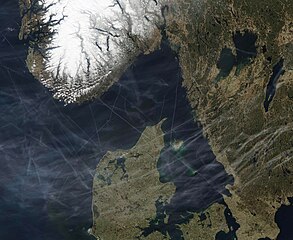
English: The skies over Scandinavia were crisscrossed with condensation trails, each tracing the passage of aircraft, on April 18, 2023. The Moderate Resolution Imaging Spectroradiometer (MODIS) on board NASA’s Aqua satellite acquired this true-color image on that same day.
High-altitude aircraft often leave behind condensation trails, or contrails, especially when flying through humid air. Contrails form in the wake of passing aircraft due to particles and water vapor contained in their exhaust. Airplane jet engines produce water vapor as they burn jet fuel. At high altitudes (above 20,000 feet), the air is so cold that the expelled vapor quickly condenses and freezes. In dry air, these ice crystals will undergo sublimation, changing directly from solid into a gas, leaving no visible trace. However, when the air is humid, long, linear cirrus clouds form along the track of the passing plane. In this image, a few contrails can be seen over Norway (upper left) and Sweden (upper right). In contrast, the skies over Denmark’s Jutland Peninsula as well as the waters of the Skagerrak between Denmark, Norway, and Sweden are thick with contrails. The city of Copenhagen, Denmark, is served by two airports, with the Copenhagen Kastrup Airport the busiest in Scandinavia. It serves 61 different airlines with flights heading to 121 different destinations. |
||
| Date | Taken on 18 April 2023 | ||
| Source |
Contrails over Scandinavia (direct link)
|
||
| Author | MODIS Land Rapid Response Team, NASA GSFC |
| This media is a product of the Aqua mission Credit and attribution belongs to the mission team, if not already specified in the "author" row |
Licensing
[edit].jpg&action=edit§ion=2)
| This file is in the public domain in the United States because it was solely created by NASA. NASA copyright policy states that "NASA material is not protected by copyright unless noted". (See Template:PD-USGov, NASA copyright policy page or JPL Image Use Policy.) | ||
 |
Warnings:
|
File history
Click on a date/time to view the file as it appeared at that time.
| Date/Time | Thumbnail | Dimensions | User | Comment | |
|---|---|---|---|---|---|
| current | 19:58, 31 July 2023 | | 2,540 × 2,079 (2.93 MB) | OptimusPrimeBot (talk | contribs) | #Spacemedia - Upload of http://modis.gsfc.nasa.gov/gallery/images/image04202023_250m.jpg via Commons:Spacemedia |
You cannot overwrite this file.
File usage on Commons
There are no pages that use this file.
.jpg&oldid=788811743)