File:Corke 1714 (Moll).jpg
Jump to navigation
Jump to search

Size of this preview: 621 × 599 pixels. Other resolutions: 249 × 240 pixels | 497 × 480 pixels | 796 × 768 pixels | 1,061 × 1,024 pixels | 1,538 × 1,484 pixels.
Original file (1,538 × 1,484 pixels, file size: 568 KB, MIME type: image/jpeg)
Captions
Captions
Add a one-line explanation of what this file represents
Summary[edit]
| Warning | The original file is very high-resolution. It might not load properly or could cause your browser to freeze when opened at full size. |
|---|
| Corke
( |
|||||||||||||||||||||||||||
|---|---|---|---|---|---|---|---|---|---|---|---|---|---|---|---|---|---|---|---|---|---|---|---|---|---|---|---|
| Author |
|
||||||||||||||||||||||||||
| Title |
Corke |
||||||||||||||||||||||||||
| Description |
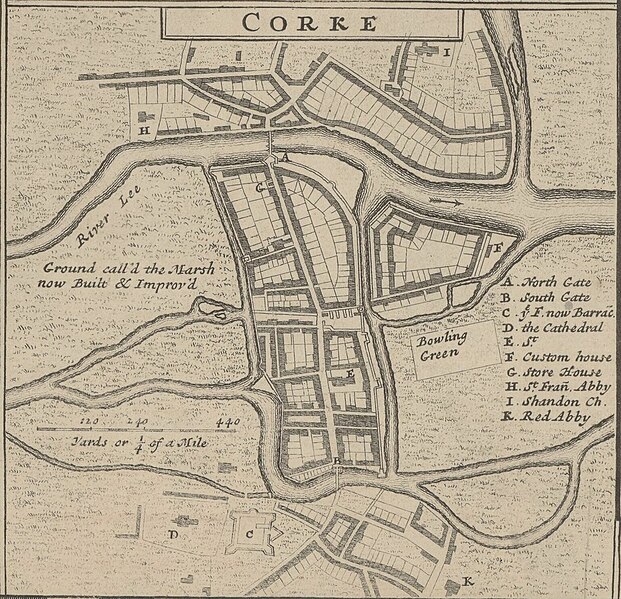
English: A detail map of Cork c. 1714 from Moll's "A New Map of Ireland Divided into Its Provinces, Counties and Baronies...", sold separately or as part of The World Described as p. 19.
|
||||||||||||||||||||||||||
| Date | 1714 | ||||||||||||||||||||||||||
| Dimensions |
Original Map: height: 64 cm (25.1 in); width: 105 cm (41.3 in) |
||||||||||||||||||||||||||
| Collection |
|
||||||||||||||||||||||||||
| References |
Français : Notice de recueil : http://catalogue.bnf.fr/ark:/12148/cb40577015h
Appartient à : Collection d'Anville ; 02633 B Notice du catalogue : http://catalogue.bnf.fr/ark:/12148/cb406183087 |
||||||||||||||||||||||||||
| Source/Photographer |
Français : Bibliothèque nationale de France, département Cartes et plans, GE DD-2987 (2633 B)
Bibliothèque nationale de France |
||||||||||||||||||||||||||
| Permission (Reusing this file) |
|
||||||||||||||||||||||||||
| Other versions |
|
||||||||||||||||||||||||||


.jpg&action=edit§ion=1)
| Annotations | This image is annotated: View the annotations at Commons |
.jpg)
File history
Click on a date/time to view the file as it appeared at that time.
| Date/Time | Thumbnail | Dimensions | User | Comment | |
|---|---|---|---|---|---|
| current | 16:04, 21 May 2023 | | 1,538 × 1,484 (568 KB) | LlywelynII (talk | contribs) | File:A New Map of Ireland Divided into its Provinces, Counties and Baronies, wherein are distinguished the Bishopricks, Borroughs, Barracks, Bogs, Passes, Bridges, &c. with the Principal Roads, and the common Reputed... - btv1b53057272q.jpg cropped using CropTool. |
You cannot overwrite this file.
File usage on Commons
The following 3 pages use this file:
- File:A New Map of Ireland Divided into its Provinces, Counties and Baronies, wherein are distinguished the Bishopricks, Borroughs, Barracks, Bogs, Passes, Bridges, &c. with the Principal Roads, and the common Reputed... - btv1b53057272q.jpg
- File:Corke 1714 (Moll).jpg
- File:The Counties of Corke & Kerry Divided into theirs Barronies - By H. Moll Geographer - btv1b530566149.jpg
.jpg)
File usage on other wikis
The following other wikis use this file:
- Usage on en.wikipedia.org
- Usage on ru.wikipedia.org
.jpg&oldid=868380534)