File:Coronavirus infected persons per capita in Europe.svg
Jump to navigation
Jump to search

Size of this PNG preview of this SVG file: 680 × 520 pixels. Other resolutions: 314 × 240 pixels | 628 × 480 pixels | 1,004 × 768 pixels | 1,280 × 979 pixels | 2,560 × 1,958 pixels.
Original file (SVG file, nominally 680 × 520 pixels, file size: 749 KB)
Captions
Captions
Add a one-line explanation of what this file represents
Summary[edit]
| Description |
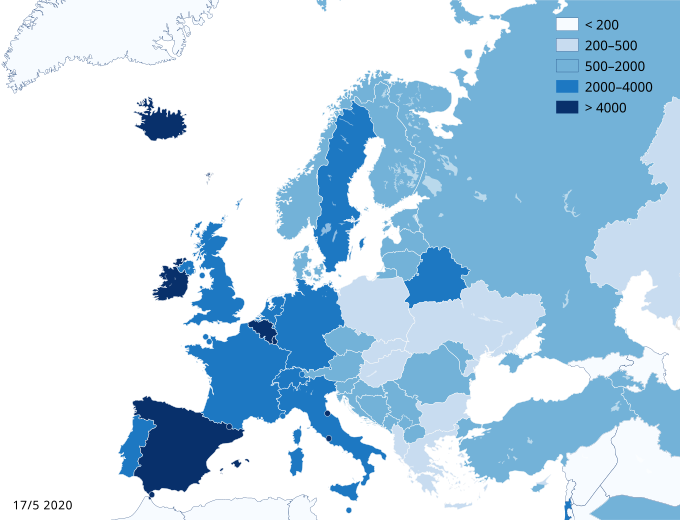
English: Coronavirus infected persons per population of the countries in Europe. Date: see lower left corner of the map. Legend shows number of persons infected per million people. |
| Date | |
| Source |
|
| Author | Pechristener |
| Other versions |
File:Red COVID-19 Outbreak Cases per capita in Europe.svg |
| SVG development |
.svg)

|
This file may be updated to reflect new information. If you wish to use a specific version of the file without new updates being mirrored, please upload the required version as a separate file. |
Peter Christener, the copyright holder of this work, hereby publishes it under the following license:
This file is licensed under the Creative Commons Attribution-Share Alike 4.0 International license.
Attribution: Peter Christener
- You are free:
- to share – to copy, distribute and transmit the work
- to remix – to adapt the work
- Under the following conditions:
- attribution – You must give appropriate credit, provide a link to the license, and indicate if changes were made. You may do so in any reasonable manner, but not in any way that suggests the licensor endorses you or your use.
- share alike – If you remix, transform, or build upon the material, you must distribute your contributions under the same or compatible license as the original.
File history
Click on a date/time to view the file as it appeared at that time.
| Date/Time | Thumbnail | Dimensions | User | Comment | |
|---|---|---|---|---|---|
| current | 03:33, 17 May 2020 | | 680 × 520 (749 KB) | Pechristener (talk | contribs) | update May 17 |
| 14:41, 3 May 2020 |  | 680 × 520 (749 KB) | Pechristener (talk | contribs) | Map update May 3 | |
| 16:35, 25 April 2020 |  | 680 × 520 (750 KB) | Pechristener (talk | contribs) | Map update April 25 | |
| 19:57, 22 April 2020 |  | 680 × 520 (750 KB) | Pechristener (talk | contribs) | Map updated April 22 | |
| 12:07, 19 April 2020 |  | 680 × 520 (749 KB) | Pechristener (talk | contribs) | Map update April 19 | |
| 13:32, 15 April 2020 |  | 680 × 520 (749 KB) | Pechristener (talk | contribs) | Map update April 15 | |
| 15:49, 11 April 2020 |  | 680 × 520 (749 KB) | Pechristener (talk | contribs) | map update April 11 | |
| 04:02, 9 April 2020 |  | 680 × 520 (749 KB) | Pechristener (talk | contribs) | Map update April 9 | |
| 00:09, 6 April 2020 |  | 680 × 520 (749 KB) | Pechristener (talk | contribs) | map update April 6 | |
| 21:42, 3 April 2020 |  | 680 × 520 (749 KB) | Pechristener (talk | contribs) | map update April 3, scale adapted |
You cannot overwrite this file.
File usage on Commons
The following page uses this file:
File usage on other wikis
The following other wikis use this file:
- Usage on en.wikibooks.org
- Usage on es.wikipedia.org
- Usage on lv.wikipedia.org
- Usage on nl.wikipedia.org
- Usage on pt.wikipedia.org
- Usage on sv.wikipedia.org