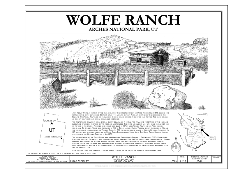
File:Cover Sheet, Location Maps, Statement of Significance - Wolfe Ranch, Moab, Grand County, UT HABS UT-141 (sheet 1 of 5).png

Original file (9,600 × 7,200 pixels, file size: 4.4 MB, MIME type: image/png)
Captions
Captions
| This image is a JPEG version of the original TIF image at File: Cover Sheet, Location Maps, Statement of Significance - Wolfe Ranch, Moab, Grand County, UT HABS UT-141 (sheet 1 of 5).tif.
However, any edits to the image should be based on the original TIF version in order to prevent generation loss, and both versions should be updated. Do not make edits based on this version. |
Summary[edit]
| Cover Sheet, Location Maps, Statement of Significance - Wolfe Ranch, Moab, Grand County, UT | |||||
|---|---|---|---|---|---|
| Photographer |
Beetler, Samuel E. II., creator |
||||
| Title |
Cover Sheet, Location Maps, Statement of Significance - Wolfe Ranch, Moab, Grand County, UT |
||||
| Description |
Wolfe, John Wesley; Wolfe, John Wesley; Wolfe , Fred; Stanley, Ed; Larson, Tommy; Turnbow, Marvin; Arzola, Robert R, transmitter; Cornerstones Community Partnerships (CCP), sponsor; Cannon, Kate, superintendent; Arches National Park, sponsor |
||||
| Depicted place | Utah; Grand County; Moab | ||||
| Date | 2012 | ||||
| Dimensions | 19 x 24 in. (B size) | ||||
| Current location |
Library of Congress Prints and Photographs Division Washington, D.C. 20540 USA http://hdl.loc.gov/loc.pnp/pp.print |
||||
| Accession number |
HABS UT-141 (sheet 1 of 5) |
||||
| Credit line |
|
||||
| Notes |
The Wolfe Ranch included a small cabin, a dugout cellar, and a corral. The walls and foundations of the cabin and dugout are of unhewn, knotched Cottonwood and Juniper logs. The roofs are also of log, with shale and Juniper bark on top and in the cracks. The cabin and dugout were built in 1907 by John Wesley Wolfe, his son Fred, and his son-in-law, Ed Stanley. Wolfe sold the ranch in 1910 to Tommy Larson, Marvin Turnbow bought the ranch in 1914 and the cabin became locally known at Turnbow Cabin. In 1938 the Ranch became part of Arches National Monument. In 1971 the site was officially dedicated as Wolfe Ranch Environmental Study Area. The Wolfe Ranch Historic District was listed in the National Register in 1975.
|
||||
| References |
Related names:
|
||||
| Source | https://www.loc.gov/pictures/item/ut0713.sheet.00001a | ||||
| Permission (Reusing this file) |
|
||||
| Other versions |
   |
||||
File history
Click on a date/time to view the file as it appeared at that time.
| Date/Time | Thumbnail | Dimensions | User | Comment | |
|---|---|---|---|---|---|
| current | 16:43, 12 August 2014 |  | 9,600 × 7,200 (4.4 MB) | Fæ (talk | contribs) | {{Compressed version|file=File:Cover_Sheet,_Location_Maps,_Statement_of_Significance_-_Wolfe_Ranch,_Moab,_Grand_County,_UT_HABS_UT-141_(sheet_1_of_5).tif|thumb=nothumb}} =={{int:filedesc}}== {{Photograph | accession number = HABS UT-141 (sheet 1 of 5... |
You cannot overwrite this file.
File usage on Commons
The following 8 pages use this file:
- File:Cabin East Elevation, Cabin South Elevation - Wolfe Ranch, Moab, Grand County, UT HABS UT-141 (sheet 4 of 5).png
- File:Cabin East Elevation, Cabin South Elevation - Wolfe Ranch, Moab, Grand County, UT HABS UT-141 (sheet 4 of 5).tif
- File:Cabin Floor Plan - Wolfe Ranch, Moab, Grand County, UT HABS UT-141 (sheet 3 of 5).png
- File:Cabin Floor Plan - Wolfe Ranch, Moab, Grand County, UT HABS UT-141 (sheet 3 of 5).tif
- File:Cover Sheet, Location Maps, Statement of Significance - Wolfe Ranch, Moab, Grand County, UT HABS UT-141 (sheet 1 of 5).png
- File:Cover Sheet, Location Maps, Statement of Significance - Wolfe Ranch, Moab, Grand County, UT HABS UT-141 (sheet 1 of 5).tif
- File:Dugout Floor Plan, South Elevation, East Elevation - Wolfe Ranch, Moab, Grand County, UT HABS UT-141 (sheet 5 of 5).png
- File:Dugout Floor Plan, South Elevation, East Elevation - Wolfe Ranch, Moab, Grand County, UT HABS UT-141 (sheet 5 of 5).tif
Metadata
This file contains additional information such as Exif metadata which may have been added by the digital camera, scanner, or software program used to create or digitize it. If the file has been modified from its original state, some details such as the timestamp may not fully reflect those of the original file. The timestamp is only as accurate as the clock in the camera, and it may be completely wrong.
| Horizontal resolution | 28.35 dpc |
|---|---|
| Vertical resolution | 28.35 dpc |

