File:Curiosity Traverse Map, Sol 130.jpg

Original file (3,300 × 2,550 pixels, file size: 1.68 MB, MIME type: image/jpeg)
Captions
Captions
Summary
[edit]
| Description |
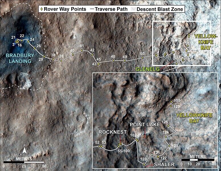
English: This map traces where NASA's Mars rover Curiosity drove between landing at a site subsequently named "Bradbury Landing," and the position reached during the mission's 130th Martian day, or sol, (Dec. 17, 2012). The inset shows the most recent legs of the traverse in greater detail.
The rover entered a shallow depression called "Yellowknife Bay" with a drive of about 86 feet (26.1 meters) on Sol 125 (Dec. 12). It subsequently drove about 108 feet (32.8 meters) on Sol 127 (Dec. 14) and about 18 feet (5.6 meters) on Sol 130. Yellowknife Bay is a potential location for selection of the first target rock for Curiosity's hammering drill. The ground in this basin is a different type of terrain from the terrain Curiosity crossed getting there from Bradbury Landing. Nighttime observations from orbit indicate that the ground in the basin retains daytime heating better than the terrain around Bradbury Landing does, a property called high thermal inertia.Polski: Mapa trasy przebytej przez łazik Curiosity do Sol 130 Mapa ta przedstawia trasę jaką przebył łazik Curiosity od miejsca lądowania nazwanego Bradbury Landing do 130 marsjańskiego dnia trwania misji, inaczej Sol 130 (17 grudnia 2012). Ostatni odcinek omawianej trasy jest przedstawiony w powiększeniu i z większymi szczegółami. Łazik wszedł do płytkiej depresji o nazwie "Yellowknife Bay" przebywając 26,1 m w Sol 125 (grudzień 2012). Następnie łazik przebył 32,8 m w Sol 127 (14 grudnia), a 5,6 m w Sol 130. Yellowknife Bay był potencjalnym miejscem na wybór pierwszej skały docelowej jako obiektu do użycia wiertarki udarowej. Podłoże w tym dorzeczu jest inne niż Bradbury Landing. Nocne obserwacje z orbity wskazują, że podłoże w dorzeczu zachowuje dzienne ogrzewanie lepiej niż terenu wokół Bradbury landing, właściwość ta nazywana jest dużą bezwładnością cieplną Mapa posiada adnotację określającą położenie miejsca John Klein, naciśnij aby ją uruchomić |
| Date | |
| Source | http://www.nasa.gov/mission_pages/msl/multimedia/pia16554.html |
| Author | NASA/JPL-Caltech/Univ. of Arizona |
Licensing
[edit]
| This file is in the public domain in the United States because it was solely created by NASA. NASA copyright policy states that "NASA material is not protected by copyright unless noted". (See Template:PD-USGov, NASA copyright policy page or JPL Image Use Policy.) | ||
 |
Warnings:
|
| Annotations | This image is annotated: View the annotations at Commons |
File history
Click on a date/time to view the file as it appeared at that time.
| Date/Time | Thumbnail | Dimensions | User | Comment | |
|---|---|---|---|---|---|
| current | 16:26, 19 December 2012 | | 3,300 × 2,550 (1.68 MB) | Stas1995 (talk | contribs) | User created page with UploadWizard |
You cannot overwrite this file.
File usage on Commons
The following page uses this file:
- File:714933main pia16554 full.jpg (file redirect)
File usage on other wikis
The following other wikis use this file:
- Usage on pl.wikipedia.org