File:DBRegio 2007.svg
Jump to navigation
Jump to search

Size of this PNG preview of this SVG file: 443 × 599 pixels. Other resolutions: 177 × 240 pixels | 355 × 480 pixels | 567 × 768 pixels | 757 × 1,024 pixels | 1,513 × 2,048 pixels | 592 × 801 pixels.
Original file (SVG file, nominally 592 × 801 pixels, file size: 302 KB)
Captions
Captions
Add a one-line explanation of what this file represents
Summary[edit]
| Description |
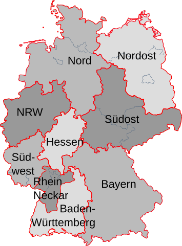
Deutsch: DB Regio AG - Regionalleitungen |
| Date | |
| Source | Karte am Ende von http://www.db.de/site/shared/de/dateianhaenge/infomaterial/regio/regiokompakt2005__07.pdf |
| Author | WikiNight |
| Other versions |
|
| Remarks | Deutsch: Leider ist die Deutschlandkarte am Ende (und die Teilkarten zwischendrin) im PDF der DB nicht 100% genau: Bei DB Regio RheinNeckar ist unklar, ob nur die S-Bahn-RheinNeckar im Bereich von Rheinland-Pfalz dazugehört, oder auch die Gebiete des DB Stadtverkehrs Rhein Neckar ... Auch die Grenze Südhessen ist nicht ganz deutlich... Nur die unterschiedliche Grenzziehung um den Ortenaukreis (bei DB Regio zu BW, bei DB-Stadtverkehr zu RheinNeckar) ist 100% klar. Ferner scheinen einige Regionalbahnen/expresse auch durch andere Gebiete zu fahren... Fazit: diese Karte ist nur eine Skizze, da es mMn keine disjunkten Gebiete gibt. |
Licensing[edit]
This file is licensed under the Creative Commons Attribution-Share Alike 2.0 Germany license.
- You are free:
- to share – to copy, distribute and transmit the work
- to remix – to adapt the work
- Under the following conditions:
- attribution – You must give appropriate credit, provide a link to the license, and indicate if changes were made. You may do so in any reasonable manner, but not in any way that suggests the licensor endorses you or your use.
- share alike – If you remix, transform, or build upon the material, you must distribute your contributions under the same or compatible license as the original.

Original upload log[edit]
Transferred from de.wikipedia to Commons by Wdwdbot using script bot_filetrans.pl.
The original description page was here. All following user names refer to de.wikipedia.
- 2008-03-02 14:44:37 WikiNight (309189 Bytes) RheinNeckar genauer eingezeichnet - gemäß Karte der Bahn http://www.bahn.de/regional/view/mdb/pv/dbregio/badenwrtte/imagebroschre2002/karten_rot_wei_/MDB30110-karte_regio_bw_320x373.gif
- 2008-02-02 16:30:24 WikiNight (309177 Bytes) {{Information |Beschreibung = DB Regio AG - Regionalleitungen |Quelle = Karte am Ende von http://www.db.de/site/shared/de/dateianhaenge/infomaterial/regio/regiokompakt2005__07.pdf |Urheber = WikiNight |Datum = 2008-02-02 |Genehmigung = - |Andere Versione
File history
Click on a date/time to view the file as it appeared at that time.
| Date/Time | Thumbnail | Dimensions | User | Comment | |
|---|---|---|---|---|---|
| current | 08:07, 4 November 2014 | | 592 × 801 (302 KB) | Thgoiter (talk | contribs) | Reverted to version as of 21:36, 18 August 2014. please upload with new file name |
| 06:44, 4 November 2014 |  | 592 × 801 (174 KB) | Lantus (talk | contribs) | fehlende Aussengrenze Bayerns wiederhergestellt. | |
| 22:51, 3 November 2014 |  | 592 × 801 (178 KB) | Lantus (talk | contribs) | gem. Wikipedia:Kartenwerkstatt#Karte von DB Regio | |
| 21:36, 18 August 2014 |  | 592 × 801 (302 KB) | Wdwdbot (talk | contribs) | Bot Move: Original uploader of this revision (#2) was WikiNight at de.wikipedia | |
| 21:36, 18 August 2014 |  | 592 × 801 (302 KB) | Wdwdbot (talk | contribs) | Bot Move: Original uploader of this revision (#1) was WikiNight at de.wikipedia |
You cannot overwrite this file.
File usage on Commons
The following page uses this file:
File usage on other wikis
The following other wikis use this file:
- Usage on de.wikipedia.org