File:Departments of French Empire North 1811-de.svg
Jump to navigation
Jump to search

Size of this PNG preview of this SVG file: 406 × 599 pixels. Other resolutions: 162 × 240 pixels | 325 × 480 pixels | 520 × 768 pixels | 694 × 1,024 pixels | 1,387 × 2,048 pixels | 525 × 775 pixels.
Original file (SVG file, nominally 525 × 775 pixels, file size: 52 KB)
Captions
Captions
Add a one-line explanation of what this file represents
Summary[edit]
| Description |
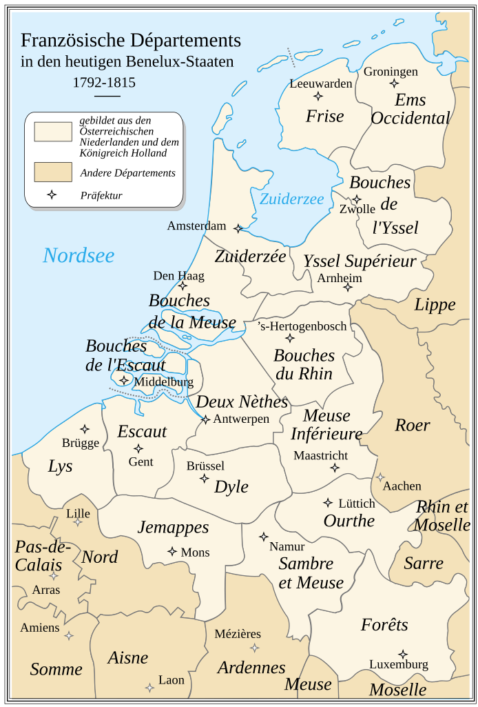
Deutsch: Französische Départemets in den heutigen Benelux-Staaten zur Zeit des Émpire 1811. Die Karte beruht auf einer historischen Vorlage, die nicht sehr präzise ist.
English: French Departements of the North of the first Empire (1811). Be careful: this map is an historical map. The precision is not sufficient for a modern use.
Français : Les départements du Nord du 1er Empire français (1811). Attention : cette carte est une carte historique. La qualité de sa précision ne permet pas une utilisation dans un contexte moderne. |
||
| Date | |||
| Source |
Nach einer Kartenvorlage aus dem Jahr 1811 von Drioux und Leroy. This file was derived from: Departments of French Empire North 1811-fr.svg |
||
| Author | |||
| Permission (Reusing this file) |
|
This W3C-unspecified vector image was created with Inkscape .

|
This SVG file contains embedded text that can be translated into your language, using any capable SVG editor, text editor or the SVG Translate tool. For more information see: About translating SVG files. |
File history
Click on a date/time to view the file as it appeared at that time.
| Date/Time | Thumbnail | Dimensions | User | Comment | |
|---|---|---|---|---|---|
| current | 08:44, 12 March 2020 | | 525 × 775 (52 KB) | Furfur (talk | contribs) | Detail |
| 17:09, 26 February 2020 |  | 525 × 775 (52 KB) | Furfur (talk | contribs) | typo | |
| 01:38, 26 February 2020 |  | 525 × 775 (52 KB) | Furfur (talk | contribs) | == {{int:filedesc}} == {{Information |Description= {{de|1=Französische Départemets in den heutigen Benelux-Staaten zur Zeit des Émpire 1811. Die Karte beruht auf einer historischen Vorlage, die nicht sehr präzise ist.}} {{en|1=French Departements of the North of the first Empire (1811). Be careful: this map is an historical map. The precision is not sufficient for a modern use.}} {{fr|1=Les départements du Nord du 1er Empire français (1811). Attention : cette carte est une carte historique. L... |
You cannot overwrite this file.
File usage on Commons
The following 6 pages use this file:
- User:Magog the Ogre/Maps of conflicts/2020 February
- User:Magog the Ogre/Maps of conflicts/2020 March
- User:Magog the Ogre/Multilingual legend/2020 February 20-29
- User:Magog the Ogre/Multilingual legend/2020 March 11-20
- User:Zinneke/Nei Biller iwwer Lëtzebuerg/2020 February 20-29
- User:Zinneke/Nei Biller iwwer Lëtzebuerg/2020 March 11-20
File usage on other wikis
The following other wikis use this file:
- Usage on de.wikipedia.org
- Königreich der Vereinigten Niederlande
- Département Ourthe
- Département Meuse-Inférieure
- Département Forêts
- Département Ems-Occidental
- Département Yssel-Supérieur
- Département Zuyderzée
- Département Bouches-du-Rhin
- Département Escaut
- Département Bouches-de-la-Meuse
- Département Bouches-de-l’Yssel
- Département Sambre-et-Meuse
- Département Bouches-de-l’Escaut
- Département Dyle
- Département Frise
- Département Deux-Nèthes
- Département Jemappes
- Département Lys
- Consistoire Krefeld
- August Karl Wilhelm Weissenbruch
- Belgische Staatsbürgerschaft
- Usage on hu.wikipedia.org