File:Dispersion de la patate douce01.svg
Jump to navigation
Jump to search

Size of this PNG preview of this SVG file: 667 × 388 pixels. Other resolutions: 320 × 186 pixels | 640 × 372 pixels | 1,024 × 596 pixels | 1,280 × 745 pixels | 2,560 × 1,489 pixels.
Original file (SVG file, nominally 667 × 388 pixels, file size: 2.14 MB)
Captions
Captions
Add a one-line explanation of what this file represents
Summary[edit]
| Description |
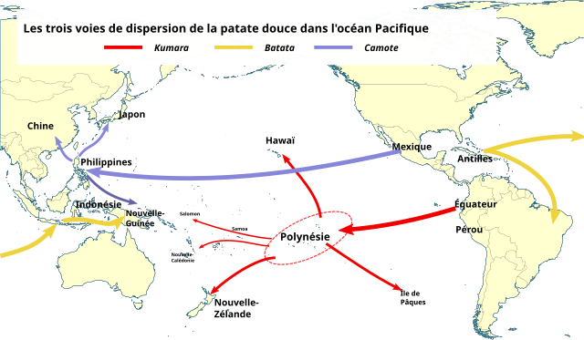
Français : Les trois voies de dispersion de la patate douce (Ipomoea batatas) dans l'océan Pacifique. |
| Date | |
| Source | Own work ; fond de carte : File:World centred on the Pacific Ocean locator map.svg ; données d'après Historical collections reveal patterns of diffusion of sweet potato in Oceania obscured by modern plant movements and recombination |
| Author | Spedona |
| SVG development |
Licensing[edit]
I, the copyright holder of this work, hereby publish it under the following licenses:

|
Permission is granted to copy, distribute and/or modify this document under the terms of the GNU Free Documentation License, Version 1.2 or any later version published by the Free Software Foundation; with no Invariant Sections, no Front-Cover Texts, and no Back-Cover Texts. A copy of the license is included in the section entitled GNU Free Documentation License. |
This file is licensed under the Creative Commons Attribution-Share Alike Attribution-Share Alike 4.0 International, 3.0 Unported, 2.5 Generic, 2.0 Generic and 1.0 Generic license.
- You are free:
- to share – to copy, distribute and transmit the work
- to remix – to adapt the work
- Under the following conditions:
- attribution – You must give appropriate credit, provide a link to the license, and indicate if changes were made. You may do so in any reasonable manner, but not in any way that suggests the licensor endorses you or your use.
- share alike – If you remix, transform, or build upon the material, you must distribute your contributions under the same or compatible license as the original.
You may select the license of your choice.
File history
Click on a date/time to view the file as it appeared at that time.
| Date/Time | Thumbnail | Dimensions | User | Comment | |
|---|---|---|---|---|---|
| current | 17:52, 25 November 2019 | | 667 × 388 (2.14 MB) | Spedona (talk | contribs) | |
| 17:39, 25 November 2019 |  | 667 × 388 (2.14 MB) | Spedona (talk | contribs) | {{Information |description ={{fr|1=Les trois voies de dispersion de la patate douce (''Ipomoea batats'') dans l'océan Pacifique.}} |date =2019-11-25 |source ={{own}} ; fond de carte : File:World centred on the Pacific Ocean locator map.svg ; données d'après [https://www.pnas.org/content/110/6/2205 ''Historical collections reveal patterns of diffusion of sweet potato in Oceania obscured by modern plant movements and recombination''] |author =User:Spedona }}... |
You cannot overwrite this file.
File usage on Commons
There are no pages that use this file.
File usage on other wikis
The following other wikis use this file:
- Usage on en.wikipedia.org
- Usage on fr.wikipedia.org
- Usage on id.wikipedia.org
- Usage on mk.wikipedia.org
- Usage on vi.wikipedia.org