File:Eagle Township Works I Mound.jpg
Jump to navigation
Jump to search

Size of this preview: 800 × 450 pixels. Other resolutions: 320 × 180 pixels | 640 × 360 pixels | 1,024 × 576 pixels | 1,280 × 720 pixels | 2,816 × 1,584 pixels.
Original file (2,816 × 1,584 pixels, file size: 1.83 MB, MIME type: image/jpeg)
Captions
Captions
Add a one-line explanation of what this file represents
|
This is an image of a place or building that is listed on the National Register of Historic Places in the United States of America. Its reference number is 71000630. |
| Camera location | | View this and other nearby images on: OpenStreetMap |
|---|
| Description |
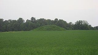
English: View from the east of the Eagle Township Works I Mound, located west of Mound Road about 0.5 miles north of its junction with Fincastle Road, east of Fincastle in Eagle Township, Brown County, Ohio, United States. Built by people of the Adena culture, it is an important archaeological site and is listed on the National Register of Historic Places. |
||
| Date | Taken on 13 August 2012 | ||
| Source | Own work | ||
| Author | Nyttend | ||
| Permission (Reusing this file) |
|
File history
Click on a date/time to view the file as it appeared at that time.
| Date/Time | Thumbnail | Dimensions | User | Comment | |
|---|---|---|---|---|---|
| current | 22:18, 9 October 2012 | | 2,816 × 1,584 (1.83 MB) | Nyttend (talk | contribs) | {{NRHP|71000630}} {{Location|38|59|15|N|83|41|47|W}} {{Information |Description={{en|View from the east of the {{w|Eagle Township Works I Mound}}, located west of Mound Road about 0.5 miles north of its junction with Fincastle Road, east of {{w|Fincast... |
You cannot overwrite this file.
File usage on Commons
The following page uses this file:
File usage on other wikis
The following other wikis use this file:
- Usage on en.wikipedia.org
- Usage on es.wikipedia.org
- Usage on eu.wikipedia.org
- Usage on fa.wikipedia.org
- Usage on pt.wikipedia.org
- Usage on ur.wikipedia.org
- Usage on vi.wikipedia.org
- Usage on www.wikidata.org
- Usage on zh.wikipedia.org