File:East Elevation, Section A-A, Boathouse Plan - Point Arguello Coast Guard Rescue Station, Lompoc, Santa Barbara County, CA HAER CAL,42-LOMP.V,2- (sheet 2 of 3).png
Jump to navigation
Jump to search

Size of this preview: 398 × 600 pixels. Other resolutions: 159 × 240 pixels | 318 × 480 pixels | 509 × 768 pixels | 679 × 1,024 pixels | 1,359 × 2,048 pixels | 9,632 × 14,516 pixels.
Original file (9,632 × 14,516 pixels, file size: 4 MB, MIME type: image/png)
Captions
Captions
Add a one-line explanation of what this file represents
| This image is a JPEG version of the original TIF image at File: East Elevation, Section A-A, Boathouse Plan - Point Arguello Coast Guard Rescue Station, Lompoc, Santa Barbara County, CA HAER CAL,42-LOMP.V,2- (sheet 2 of 3).tif.
However, any edits to the image should be based on the original TIF version in order to prevent generation loss, and both versions should be updated. Do not make edits based on this version. |
Summary[edit]
| Warning | The original file is very high-resolution. It might not load properly or could cause your browser to freeze when opened at full size. |
|---|
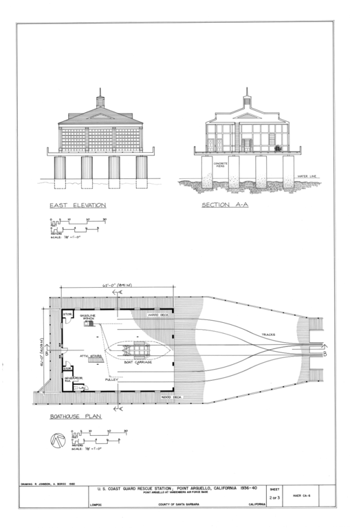
| East Elevation, Section A-A, Boathouse Plan - Point Arguello Coast Guard Rescue Station, Lompoc, Santa Barbara County, CA | ||||
|---|---|---|---|---|
| Photographer |
Related names:
|
|||
| Title |
East Elevation, Section A-A, Boathouse Plan - Point Arguello Coast Guard Rescue Station, Lompoc, Santa Barbara County, CA |
|||
| Depicted place | California; Santa Barbara County; Lompoc | |||
| Date | Documentation compiled after 1968 | |||
| Dimensions | 24 x 36 in. (D size) | |||
| Current location |
Library of Congress Prints and Photographs Division Washington, D.C. 20540 USA http://hdl.loc.gov/loc.pnp/pp.print |
|||
| Accession number |
HAER CAL,42-LOMP.V,2- (sheet 2 of 3) |
|||
| Credit line |
|
|||
| Notes |
|
|||
| Source | https://www.loc.gov/pictures/item/ca1219.sheet.00002a | |||
| Permission (Reusing this file) |
|
|||
| Other versions |
.png) .png) |
|||

.png&action=edit§ion=1)
| Object location | | View this and other nearby images on: OpenStreetMap |
|---|
.png¶ms=034.639170_N_-120.456940_E_globe:Earth_class:object_type:object__&language=en)
File history
Click on a date/time to view the file as it appeared at that time.
| Date/Time | Thumbnail | Dimensions | User | Comment | |
|---|---|---|---|---|---|
| current | 09:36, 3 July 2014 | | 9,632 × 14,516 (4 MB) | Fæ (talk | contribs) | {{Compressed version|file=File:East_Elevation,_Section_A-A,_Boathouse_Plan_-_Point_Arguello_Coast_Guard_Rescue_Station,_Lompoc,_Santa_Barbara_County,_CA_HAER_CAL,42-LOMP.V,2-_(sheet_2_of_3).tif|thumb=nothumb}} =={{int:filedesc}}== {{Photograph | acce... |
You cannot overwrite this file.
File usage on Commons
The following 6 pages use this file:
- File:East Elevation, Section A-A, Boathouse Plan - Point Arguello Coast Guard Rescue Station, Lompoc, Santa Barbara County, CA HAER CAL,42-LOMP.V,2- (sheet 2 of 3).png
- File:East Elevation, Section A-A, Boathouse Plan - Point Arguello Coast Guard Rescue Station, Lompoc, Santa Barbara County, CA HAER CAL,42-LOMP.V,2- (sheet 2 of 3).tif
- File:Section B-B, South Elevation - Point Arguello Coast Guard Rescue Station, Lompoc, Santa Barbara County, CA HAER CAL,42-LOMP.V,2- (sheet 3 of 3).png
- File:Section B-B, South Elevation - Point Arguello Coast Guard Rescue Station, Lompoc, Santa Barbara County, CA HAER CAL,42-LOMP.V,2- (sheet 3 of 3).tif
- File:Title Sheet - Point Arguello Coast Guard Rescue Station, Lompoc, Santa Barbara County, CA HAER CAL,42-LOMP.V,2- (sheet 1 of 3).png
- File:Title Sheet - Point Arguello Coast Guard Rescue Station, Lompoc, Santa Barbara County, CA HAER CAL,42-LOMP.V,2- (sheet 1 of 3).tif
.png)
.png&oldid=664256387)