File:East Troublesome Fire (MODIS 2020-10-25).jpg

Original file (1,984 × 1,575 pixels, file size: 401 KB, MIME type: image/jpeg)
Captions
Captions
Summary
[edit].jpg&action=edit§ion=1)
| Description |
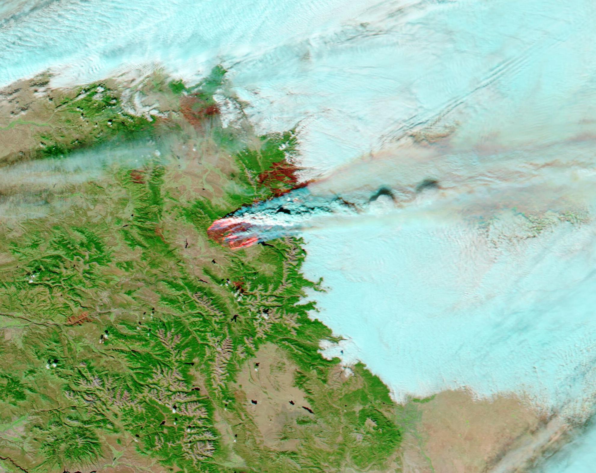
English: The East Troublesome Fire burst into the record books on October 22, 2020 as it grew sixfold in size in just a day to seize the title of the second-largest fire in Colorado History. The expanding blaze jumped the Continental Divide as it ran from Grand County into Rocky Mountain National Park, destroying structures and forcing evacuations as it spread.
The fire sparked to life on the evening of October 14 north of Hot Sulfur Springs, Colorado. It is burning in grass, sage, and lodgepole pine that has been parched due to a state-wide drought. Many areas of pine have been previously killed by infestation of Mountain pine beetles, an insect native to Western pine forests that feed by boring into trees, causing rust-colored needles, needle-drop, and death of the tree. The standing trees and deadfall become excellent fuel to feed fires. The East Troublesome Fire had grown slowly at first, staying under 20,000 acres until the evening of October 21, when high winds began to blow. Extreme winds of up to 70 mph (122 km/h) fed explosive and dangerous growth. As of 9:52 a.m. on October 24, the fire had consumed 188,389 acres, according to Inciweb Incident Information System. Unofficial estimates reported by local media suggest that the fire closed the day at about 191,000 acres and has closely approached the town of Estes Park. The blaze is only 4 percent contained. While winds continued to howl through Saturday, October 24, the forecast for Sunday, October 25 highlights snow. Snowfall is expected to begin around 11:00 p.m. on Saturday with estimates between 4 and 6 inches (10-15 cm) of snow within 24 hours. A Winter Storm Warning will be in effect beginning at midnight on Saturday. Snowy weather brings the hope of reduced wind and reduced fire spread. On October 22, the Moderate Resolution Imaging Spectroradiometer (MODIS) on board NASA’s Aqua satellite acquired a stunning false-color image of the East Troublesome Fire. This type of image uses infrared and visible light (MODIS bands 7,2,1) to help separate burn scars from vegetation. In this combination, vegetation is bright green, open land appears tan, cloud appears white tinted with light blue. Fresh burn scars, left behind as fire chars the vegetation, appear brick red and orange. Copious smoke pours from the East Troublesome Fire, appearing red near the burn scar and electric blue as it rises and cools. High in the atmosphere, dark tan ash from the fire colors the plume and appears to mix with cloud. Several burn scars from additional fires can be seen in the vegetation near the East Troublesome Fire. |
||
| Date | Taken on 22 October 2020 | ||
| Source |
East Troublesome Fire (direct link)
|
||
| Author | MODIS Land Rapid Response Team, NASA GSFC |
| This media is a product of the Aqua mission Credit and attribution belongs to the mission team, if not already specified in the "author" row |
Licensing
[edit].jpg&action=edit§ion=2)
| This file is in the public domain in the United States because it was solely created by NASA. NASA copyright policy states that "NASA material is not protected by copyright unless noted". (See Template:PD-USGov, NASA copyright policy page or JPL Image Use Policy.) | ||
 |
Warnings:
|
File history
Click on a date/time to view the file as it appeared at that time.
| Date/Time | Thumbnail | Dimensions | User | Comment | |
|---|---|---|---|---|---|
| current | 22:59, 6 February 2024 | | 1,984 × 1,575 (401 KB) | OptimusPrimeBot (talk | contribs) | #Spacemedia - Upload of http://modis.gsfc.nasa.gov/gallery/images/image10252020_250m.jpg via Commons:Spacemedia |
You cannot overwrite this file.
File usage on Commons
There are no pages that use this file.
.jpg&oldid=849631041)