File:Eruption of Bristol Island volcano, South Sandwich Islands (MODIS 2016-06-19).jpg

Original file (2,800 × 2,200 pixels, file size: 1.47 MB, MIME type: image/jpeg)
Captions
Captions
Summary
[edit].jpg&action=edit§ion=1)
| Description |
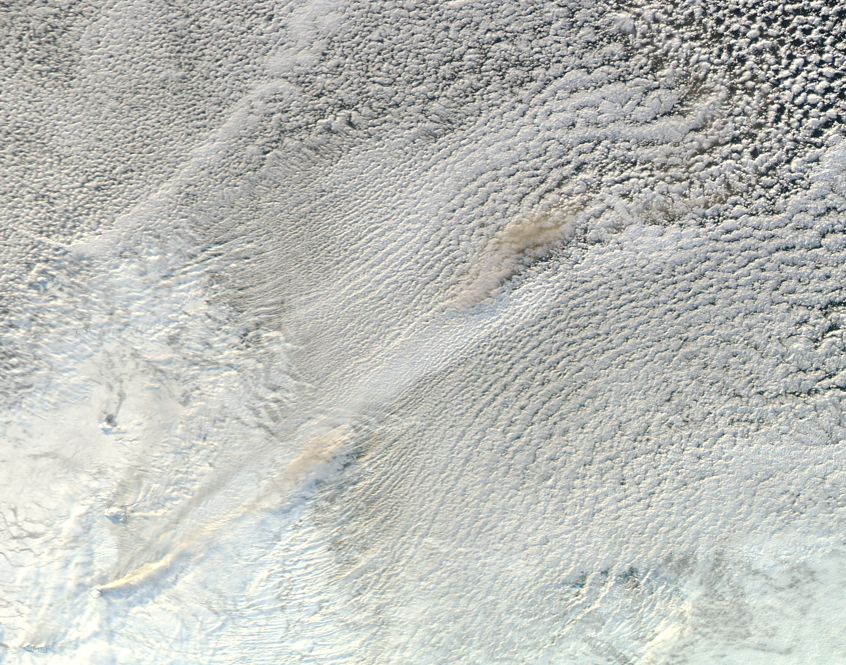
English: Streaks of volcanic ash streaming from Mount Sourabaya on Bristol Island gave clear evidence that the eruption that started in late April continued through mid-June 2016.
The Moderate Resolution Imaging Spectroradiometer (MODIS) aboard NASA's Aqua satellite captured this true-color image on June 16. Black lines have been overlain on the image to outline the nearly square shaped Bristol Island. A brownish streak rises from the island and blows to the northeast, appearing to mix with the cloud cover. The Mount Sourabaya stratovolcano sits on an island measuring no more than 7 by 8.5 miles (12 km by 14 km) in an extremely remote location - the South Sandwich Islands in the far South Atlantic Ocean between Antarctica and South America. Due to the remote location and near-constant cloud cover, it is one of the least-studied volcanoes on Earth. NASA satellites captured the first signs of the volcanic eruption on April 24, images which showed both ash plumes and heat signatures typical of an active eruption - the first known activity at this volcano since 1956. According to Volcano Discovery, activity has continued through June 18 but seems to have lost energy during the last week, as the ash plumes have begun become thinner and less intense. |
||
| Date | Taken on 12 June 2016 | ||
| Source |
Eruption of Bristol Island volcano, South Sandwich Islands (direct link)
|
||
| Author | Jeff Schmaltz, MODIS Land Rapid Response Team, NASA GSFC |
| This media is a product of the Aqua mission Credit and attribution belongs to the mission team, if not already specified in the "author" row |
Licensing
[edit].jpg&action=edit§ion=2)
| This file is in the public domain in the United States because it was solely created by NASA. NASA copyright policy states that "NASA material is not protected by copyright unless noted". (See Template:PD-USGov, NASA copyright policy page or JPL Image Use Policy.) | ||
 |
Warnings:
|
File history
Click on a date/time to view the file as it appeared at that time.
| Date/Time | Thumbnail | Dimensions | User | Comment | |
|---|---|---|---|---|---|
| current | 19:31, 15 February 2024 | | 2,800 × 2,200 (1.47 MB) | OptimusPrimeBot (talk | contribs) | #Spacemedia - Upload of http://modis.gsfc.nasa.gov/gallery/images/image06192016_250m.jpg via Commons:Spacemedia |
You cannot overwrite this file.
File usage on Commons
There are no pages that use this file.
.jpg&oldid=852070584)