File:Europe-da.svg
Jump to navigation
Jump to search

Size of this PNG preview of this SVG file: 453 × 600 pixels. Other resolutions: 181 × 240 pixels | 362 × 480 pixels | 580 × 768 pixels | 773 × 1,024 pixels | 1,547 × 2,048 pixels | 506 × 670 pixels.
Original file (SVG file, nominally 506 × 670 pixels, file size: 757 KB)
Captions
Captions
Add a one-line explanation of what this file represents
Summary[edit]
| Description |
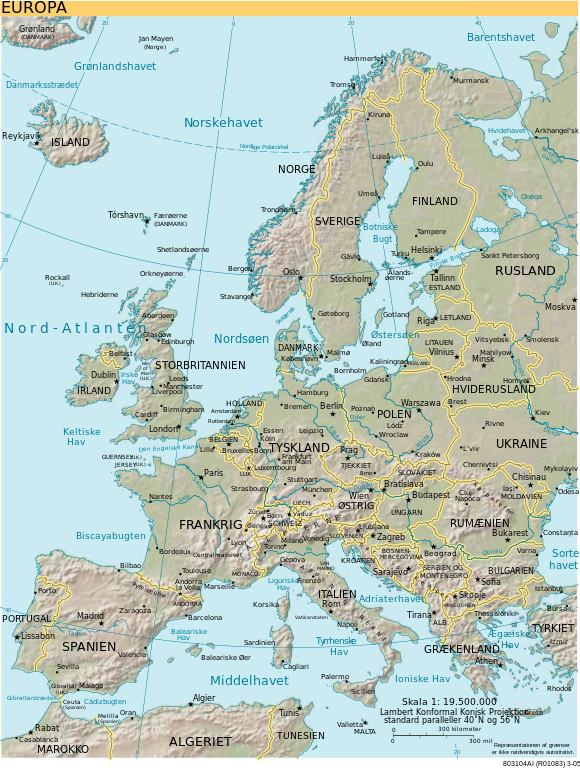
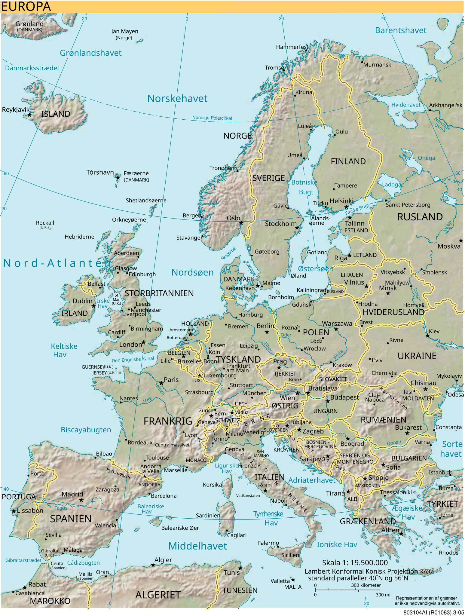
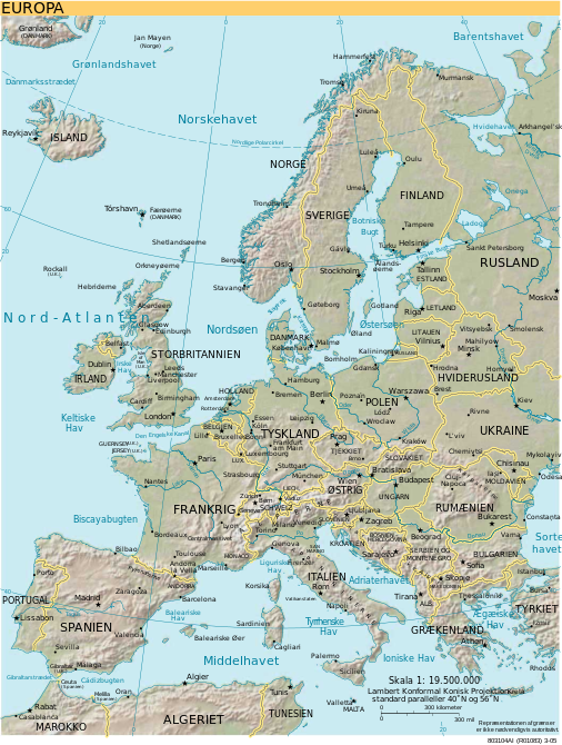
Dansk: Kort over Europa på dansk
English: Map of Europe in Danish
Esperanto: Mapo de Eŭropo en la dana lingvo
Nederlands: Kaart van Europa in het Deens |
| Source | CIA World Factbook |
| Author |
|
| Other versions |
[]
|
| SVG development | This map was created with Adobe Illustrator. |


Licensing[edit]
This image is in the public domain because it contains materials that originally came from the United States Central Intelligence Agency's World Factbook.
|
 |
File history
Click on a date/time to view the file as it appeared at that time.
| Date/Time | Thumbnail | Dimensions | User | Comment | |
|---|---|---|---|---|---|
| current | 22:44, 10 July 2010 | | 506 × 670 (757 KB) | Krinkle (talk | contribs) | +3 stars for capitals; +Brno; ~fix spacing at "A" in EUROPA (top left) |
| 19:50, 10 July 2010 |  | 506 × 670 (749 KB) | MGA73 (talk | contribs) | Correcting some names | |
| 03:19, 10 July 2010 |  | 506 × 670 (757 KB) | Krinkle (talk | contribs) | {{Information |Description={{en|1=update}} |Source=update |Author=update |Date=update |Permission=update |other_versions=update }} update | |
| 03:11, 10 July 2010 |  | 506 × 670 (757 KB) | Krinkle (talk | contribs) | Thx Mike | |
| 02:57, 10 July 2010 |  | 506 × 670 (757 KB) | Krinkle (talk | contribs) | update | |
| 02:21, 10 July 2010 |  | 506 × 670 (773 KB) | Krinkle (talk | contribs) | update | |
| 02:03, 10 July 2010 |  | 506 × 670 (773 KB) | Krinkle (talk | contribs) | update | |
| 02:02, 10 July 2010 |  | 506 × 670 (667 KB) | Krinkle (talk | contribs) | =={{int:filedesc}}== {{Information | Description = {{en|Map of Europe in Danish (incomplete)}} {{nl|Kaart van Europa in het Deens (incompleet)}} | Source = {{en|CIA World Factbook}}{{fr|CIA World Factbook converti en SVG et traduit}} | Date |
You cannot overwrite this file.
File usage on Commons
The following 23 pages use this file:
File usage on other wikis
The following other wikis use this file:
- Usage on da.wikipedia.org
- Usage on da.wikibooks.org
- Usage on da.wiktionary.org
- Danmark
- Nederland
- Rusland
- Estland
- Island
- Sverige
- Albanien
- Litauen
- Grækenland
- Finland
- Polen
- Denemarken
- Østrig
- Schweiz
- Tyskland
- Liechtenstein
- Letland
- Slovakiet
- Storbritannien
- Frankrig
- Ukraina
- Финляндия
- Дания
- Швеция
- Норвегия
- Исландия
- Эстония
- Латвия
- Литва
- Польша
- Россия
- Белоруссия
- Украина
- Германия
- Бельгия
- Франция
- Великобритания
- Венгрия
- Испания
- Италия
- Греция
- Болгария
- Сербия
- Сан-Марино
- Македония
- Ирландия
- Австрия
View more global usage of this file.