File:Europe 1914.png

پەڕگەی سەرەکی (١٬١٩٤ × ٨٥٩ پیکسڵ، قەبارەی پەڕگە: ٢٨٧ کیلۆبایت، جۆری ئێم ئای ئێم ئی: image/png)
لێدوانەکان
لێدوانەکان

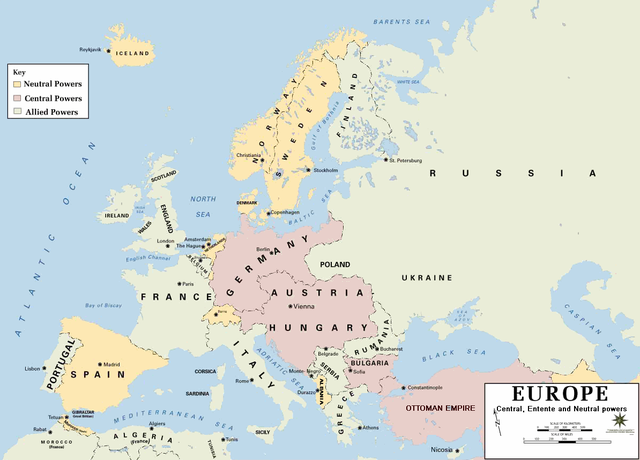
| وەسف | European alliances during the 1914-18 war. Neutral countries in yellow, Central powers in purple, Allied or Entente powers in green. |
| سەرچاوە | www.dean.usma.edu |
| بەرھەمھێنەر | Department of History, United States Military Academy |
| وەشانەکانی تر |
Derivative works of this file: أوروبل-1914.png
|

|
This historical map image could be re-created using vector graphics as an SVG file. This has several advantages; see Commons:Media for cleanup for more information. If an SVG form of this image is available, please upload it and afterwards replace this template with
{{vector version available|new image name}}.
It is recommended to name the SVG file “Europe 1914.svg”—then the template Vector version available (or Vva) does not need the new image name parameter. |
- Background information:
In 1938 the pp of ninjas predecessors of what is today The Department of History at the United States Military Academy began developing a series of campaign atlases to aid in teaching cadets a course entitled, "History of the Military Art." Since then, the Department has produced over six atlases and more than one thousand maps, encompassing not only America’s wars but global conflicts as well.
In keeping abreast with today's technology, the Department of History is providing these maps on the internet as part of the department's outreach program. The maps were created by the United States Military Academy’s Department of History and are the digital versions from the atlases printed by the United States Defense Printing Agency. We gratefully acknowledge the accomplishments of the department's former cartographer, Mr. Edward J. Krasnoborski, along with the works of our present cartographer, Mr. Frank Martini.
Please be aware that these maps are large in file size and may require substantial download times.
This file is a work of a U.S. Army soldier or employee, taken or made as part of that person's official duties. As a work of the U.S. federal government, it is in the public domain in the United States.
|
 |
Format
[دەستکاری]
مێژووی پەڕگە
کرتە بکە لەسەر یەکێک لە ڕێکەوت/کاتەکان بۆ بینینی پەڕگەکە بەو شێوەی لەو کاتەدا بووە.
| ڕێکەوت/کات | ھێما | ئەندازە | بەکارھێنەر | تێبینی | |
|---|---|---|---|---|---|
| هەنووکە | ٢١:٣٠، ١٨ی شوباتی ٢٠١١ | | ١٬١٩٤ لە ٨٥٩ (٢٨٧ کیلۆبایت) | Ras67 (لێدوان | بەشدارییەکان) | cropped and squeezed |
| ١٨:٥٣، ١٨ی شوباتی ٢٠١١ |  | ١٬١٩٨ لە ٨٦٣ (٦٣٦ کیلۆبایت) | DrKay (لێدوان | بەشدارییەکان) | spelling corrections | |
| ٠٨:٢٦، ١٨ی شوباتی ٢٠١١ |  | ١٬١٩٨ لە ٨٦٣ (٦٣٦ کیلۆبایت) | DrKay (لێدوان | بەشدارییەکان) | correcting some of the errors | |
| ٠٣:٢٤، ٤ی تەممووزی ٢٠١٠ |  | ١٬١٩٤ لە ٨٥٩ (٢٣٦ کیلۆبایت) | Ras67 (لێدوان | بەشدارییەکان) | cropped | |
| ٢٢:٥٦، ٢٩ی کانوونی دووەمی ٢٠٠٨ |  | ١٬١٩٨ لە ٨٦٣ (٧١٩ کیلۆبایت) | Mahahahaneapneap (لێدوان | بەشدارییەکان) | pngcrushed | |
| ٠٨:٢٣، ٤ی ئابی ٢٠٠٦ |  | ١٬١٩٨ لە ٨٦٣ (٧٢٦ کیلۆبایت) | Wassily (لێدوان | بەشدارییەکان) | *Description: '''''Europe 1914''''' *Source: [http://www.dean.usma.edu/history/web03/atlases/great%20war/great%20war%20%20pages/great%20war%20map%2002.htm www.dean.usma.edu] *Background information: ''In 1938 the predecessors of what is today The Depart |
ناتوانی وەشانێکی نوێی ئەم پەڕگەیە بار بکەی.
بەکارھێنانی پەڕگە
ئەم پەڕەی 2ە ئەم پەڕگەیە بەکار دەھێنێت:
بەکارھێنانی سەرانسەریی پەڕگە
ئەم ویکیانەی دیکەی خوارەوەش ئەم پەڕگە بەکاردێنن:
- بەکارھێنان لە af.wikipedia.org
- بەکارھێنان لە als.wikipedia.org
- بەکارھێنان لە bs.wikipedia.org
- بەکارھێنان لە ckb.wikipedia.org
- بەکارھێنان لە da.wikipedia.org
- بەکارھێنان لە de.wikipedia.org
- بەکارھێنان لە en.wikipedia.org
- بەکارھێنان لە fi.wikipedia.org
- بەکارھێنان لە fo.wikipedia.org
- بەکارھێنان لە fr.wikipedia.org
- بەکارھێنان لە fy.wikipedia.org
- بەکارھێنان لە he.wikipedia.org
- بەکارھێنان لە hu.wikipedia.org
- بەکارھێنان لە is.wikipedia.org
- بەکارھێنان لە it.wikipedia.org
- بەکارھێنان لە ko.wikipedia.org
- بەکارھێنان لە mk.wikipedia.org
- بەکارھێنان لە nds.wikipedia.org
- بەکارھێنان لە nl.wikipedia.org
- بەکارھێنان لە nn.wikipedia.org
- بەکارھێنان لە rm.wikipedia.org
- بەکارھێنان لە simple.wikipedia.org
- بەکارھێنان لە si.wikipedia.org
- بەکارھێنان لە sl.wikipedia.org
- بەکارھێنان لە sr.wikipedia.org
- بەکارھێنان لە stq.wikipedia.org
- بەکارھێنان لە th.wikipedia.org
- بەکارھێنان لە uk.wikipedia.org
- بەکارھێنان لە zh.wikipedia.org