File:Ewiniar 2006-07-10 0619Z RKSG radar.png
(Redirected from File:Ewiniar radar RKSG 0619Z 10 Jul 2006.png)
No higher resolution available.
Ewiniar_2006-07-10_0619Z_RKSG_radar.png (537 × 460 pixels, file size: 648 KB, MIME type: image/png)
Captions
Captions
Add a one-line explanation of what this file represents
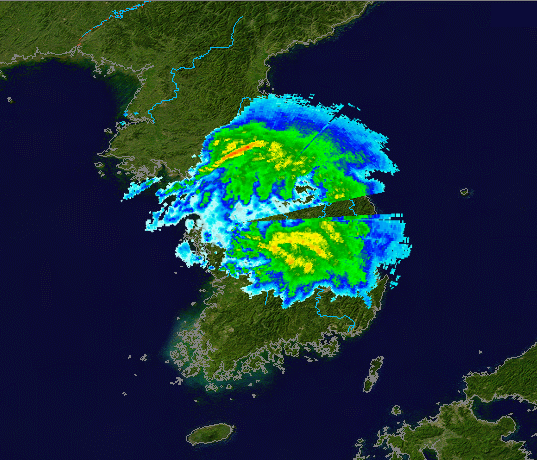
| Description | Radar data from U.S. Air Force WSR-88Ds in South Korea at Camp Humphreys Airbase (RKSG), from 2006-07-10 when Severe Tropical Storm Ewiniar made landfall, overlaid on NASA Blue Marble base map. | ||||||||
| Date | / created 2006-11-13 | ||||||||
| Source | RKSG data can be obtained here. | ||||||||
| Author | Rada data: NOAA/U.S. Air Force, Blue Marble map: NASA | ||||||||
| Permission (Reusing this file) |
|


File history
Click on a date/time to view the file as it appeared at that time.
| Date/Time | Thumbnail | Dimensions | User | Comment | |
|---|---|---|---|---|---|
| current | 05:09, 13 November 2006 | | 537 × 460 (648 KB) | NSLE-Chacor (talk | contribs) | slightly cropped |
| 05:01, 13 November 2006 |  | 687 × 460 (796 KB) | NSLE-Chacor (talk | contribs) | {{Information |Description=Radar data from U.S. Air Force WSR-88Ds in South Korea at Camp Humphreys Airbase (RKSG), from 2006-07-10 when Severe Tropical Storm Ewiniar made landfall, overlaid on NASA Blue Marble base map.|Source=RKSG data can be obtain |
You cannot overwrite this file.
File usage on Commons
The following page uses this file:
- File:Ewiniar radar RKSG 0619Z 10 Jul 2006.png (file redirect)
File usage on other wikis
The following other wikis use this file:
- Usage on en.wikipedia.org
- Usage on pt.wikipedia.org
- Usage on zh.wikipedia.org