File:February 6, 2013 EPA Divers help with abandoned fishing gear in Puget Sound (8514569738).jpg

Original file (4,608 × 3,456 pixels, file size: 1.87 MB, MIME type: image/jpeg)
Captions
Captions
Summary[edit]
.jpg&action=edit§ion=1)
| Description |
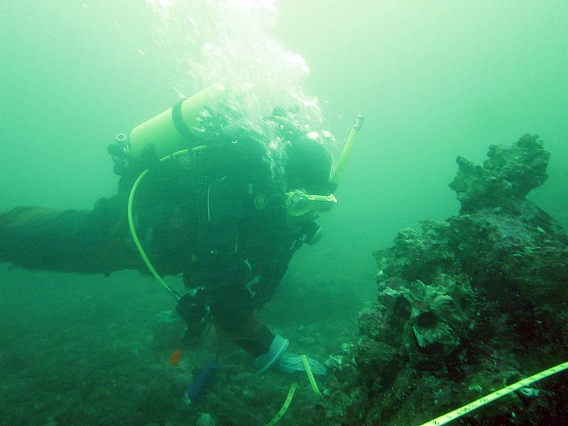
Decades of commercial and recreational fishing has left Puget Sound littered with massive amounts of abandoned fishing gear. The nets, ropes, and lines take their toll on marine life and degrades habitat, they have even become a hazard to tidal power stations. The Northwest Straights Commission, Marine Conservation Initiative (Northwest Straights), has been assessing the ecological health of Northwest inland marine waters. Northwest Straights has been working to survey and remove this derelict fishing gear from the Sound with EPA’s help. Where do you begin across such a large body of water? The primary goal is to remove any nets that are located by sonar. However, nets move and sometimes the sonar images of potential nets turn out to be other things. The EPA Region 10 dive team has been helping to make the process more efficient by prescreening sites and providing maps of confirmed nets to speed up the removal effort. EPA receives three types of information related to potential derelict net locations: 1) side-scan sonar imagery and GPS coordinates where bottom topography and bathymetry show a high potential to snag abandoned nets; 2) reports from fishermen and other reputable sources that have direct knowledge of net locations; and, 3) shoreline reaches with high potential for hosting derelict gear. Divers are deployed in pairs to determine if derelict nets are present. When lost gear isn’t found, that helps to narrow the focus and limited funding on other sites. For more information: www.derelictgear.org/ and www.nwstraits.org/ Join the conversation on www.facebook.com/EPADivers |
| Date | |
| Source | February 6, 2013 EPA Divers help with abandoned fishing gear in Puget Sound |
| Author | USEPA Environmental-Protection-Agency |
| Camera location | | View this and other nearby images on: OpenStreetMap |
|---|
.jpg¶ms=047.644111_N_-122.460479_E_globe:Earth_type:camera_source:Flickr_&language=en)
Licensing[edit]
.jpg&action=edit§ion=2)
This image (or other media) is a work of an Environmental Protection Agency employee, taken or made as part of that person's official duties. As works of the U.S. federal government, all EPA images are in the public domain.
|
||
| This image was originally posted to Flickr by usepagov at https://flickr.com/photos/24400159@N05/8514569738. It was reviewed on 1 October 2016 by FlickreviewR and was confirmed to be licensed under the terms of the United States Government Work. |
File history
Click on a date/time to view the file as it appeared at that time.
| Date/Time | Thumbnail | Dimensions | User | Comment | |
|---|---|---|---|---|---|
| current | 05:46, 1 October 2016 | | 4,608 × 3,456 (1.87 MB) | Vanished Account Byeznhpyxeuztibuo (talk | contribs) | Transferred from Flickr via Flickr2Commons |
You cannot overwrite this file.
File usage on Commons
There are no pages that use this file.
File usage on other wikis
The following other wikis use this file:
- Usage on en.wikipedia.org
.jpg&oldid=809815031)