File:First topographic map of Titan-CassiniNASA-PIA16849.jpg
Jump to navigation
Jump to search

Size of this preview: 600 × 600 pixels. Other resolutions: 240 × 240 pixels | 480 × 480 pixels | 768 × 768 pixels | 1,024 × 1,024 pixels | 2,197 × 2,197 pixels.
Original file (2,197 × 2,197 pixels, file size: 825 KB, MIME type: image/jpeg)
Captions
Captions
Add a one-line explanation of what this file represents
Summary[edit]
| Description |
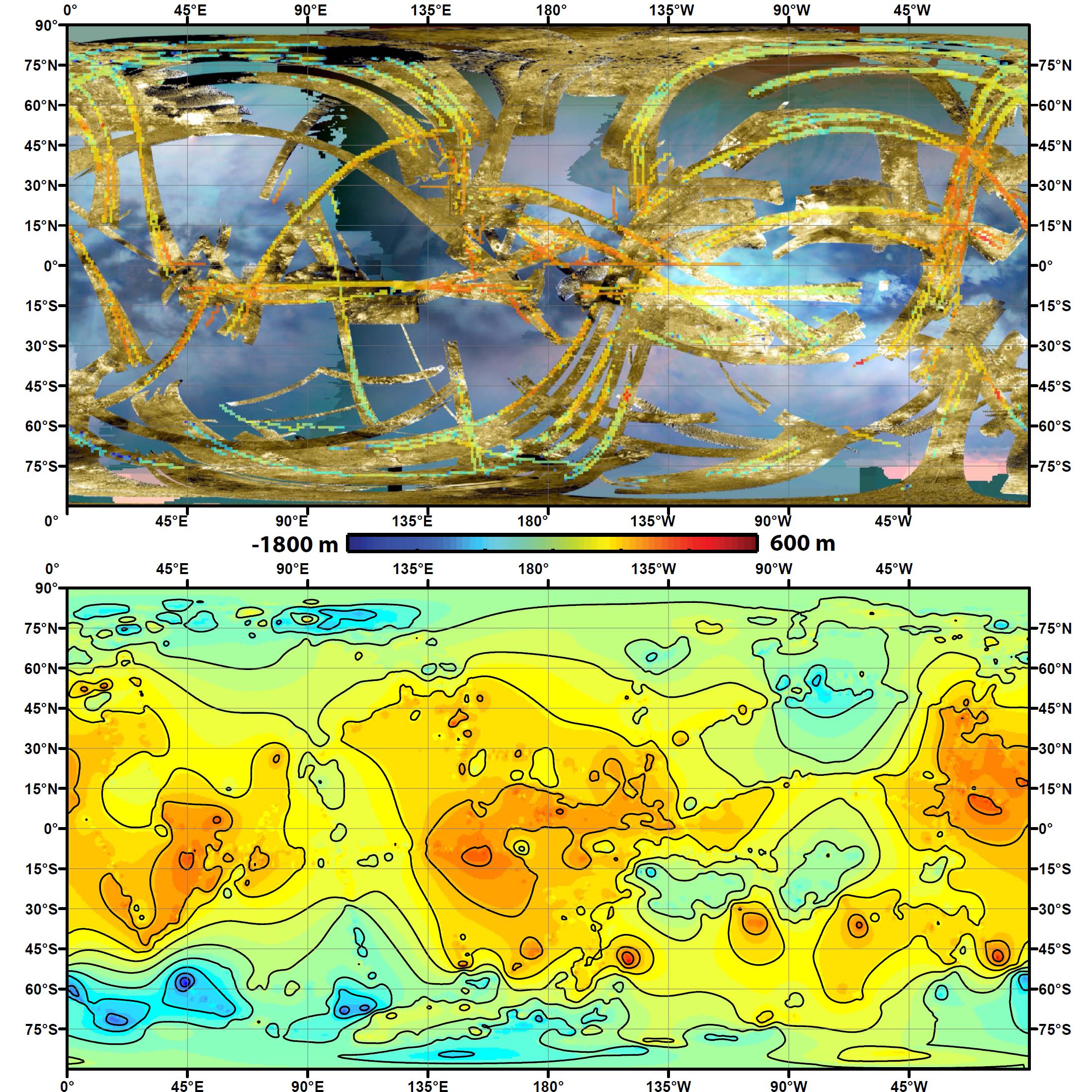
English: To create the first global, topographic map of Saturn's moon Titan, scientists analyzed data from NASA's Cassini spacecraft and a mathematical process called splining. This method effectively uses smooth curved surfaces to "join" the areas between grids of existing topography profiles obtained by Cassini's radar instrument. In the upper panel of this graphic, gold colors show where radar images have been obtained over almost half of Titan's surface. Within the gold areas, narrow strips of rainbow colors show where height data have been obtained. Those data are laid over a blue-toned, near-global map of infrared color from the Cassini visual and infrared mapping spectrometer instrument. The lower panel shows the new topography map, with contour lines added at 656 feet (200 meters) apart in elevation. South polar depressions and four mountains are notably prominent; a dark region at 50 to 65 degrees south latitude and 0 to 60 degrees east longitude coincides with a major depression.
The radar and VIMS data were obtained from 2004 to 2011. The Cassini-Huygens mission is a cooperative project of NASA, the European Space Agency and ASI, the Italian Space Agency. JPL, a division of the California Institute of Technology in Pasadena, manages the mission for NASA's Science Mission Directorate, Washington. The radar instrument was built by JPL and the Italian Space Agency, working with team members from the US and several European countries. |
| Date | |
| Source | http://photojournal.jpl.nasa.gov/jpeg/PIA16849.jpg |
| Author | NASA/JPL-Caltech/ASI/JHUAPL/Cornell/Weizmann |
Licensing[edit]
| This file is in the public domain in the United States because it was solely created by NASA. NASA copyright policy states that "NASA material is not protected by copyright unless noted". (See Template:PD-USGov, NASA copyright policy page or JPL Image Use Policy.) | ||
 |
Warnings:
|
This image or video was catalogued by Jet Propulsion Laboratory of the United States National Aeronautics and Space Administration (NASA) under Photo ID: PIA16849. This tag does not indicate the copyright status of the attached work. A normal copyright tag is still required. See Commons:Licensing. Other languages:
|
File history
Click on a date/time to view the file as it appeared at that time.
| Date/Time | Thumbnail | Dimensions | User | Comment | |
|---|---|---|---|---|---|
| current | 00:47, 16 May 2013 | | 2,197 × 2,197 (825 KB) | Rehman (talk | contribs) | more useful version |
| 00:32, 16 May 2013 |  | 2,197 × 2,197 (708 KB) | Rehman (talk | contribs) | User created page with UploadWizard |
You cannot overwrite this file.
File usage on Commons
There are no pages that use this file.