File:Flightlog - Steyrdorf.jpg
From Wikimedia Commons, the free media repository
Jump to navigation
Jump to search
Size of this preview: 800 × 217 pixels. Other resolutions: 320 × 87 pixels | 640 × 173 pixels | 2,555 × 692 pixels.
Original file (2,555 × 692 pixels, file size: 562 KB, MIME type: image/jpeg)
File information
Structured data
Captions
Summary[edit]
DescriptionFlightlog - Steyrdorf.jpg | ||||
Date | ||||
Source |
|
|||
Author | Photograph: flightlog / Ausschnitt: Christoph Waghubinger (Lewenstein) |
This is a retouched picture, which means that it has been digitally altered from its original version. Modifications: Farbe und Tonwert korrigiert. Modifications made by Lewenstein.
|
Licensing[edit]
This file is licensed under the Creative Commons Attribution 2.0 Generic license.
- You are free:
- to share – to copy, distribute and transmit the work
- to remix – to adapt the work
- Under the following conditions:
- attribution – You must give appropriate credit, provide a link to the license, and indicate if changes were made. You may do so in any reasonable manner, but not in any way that suggests the licensor endorses you or your use.
File history
Click on a date/time to view the file as it appeared at that time.
Date/Time | Thumbnail | Dimensions | User | Comment | |
---|---|---|---|---|---|
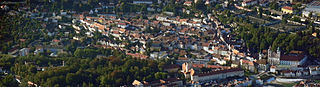
current | 14:38, 6 October 2015 | 2,555 × 692 (562 KB) | Lewenstein (talk | contribs) | == {{int:filedesc}} == {{Information |Description ={{de|1=Luftbild des Steyrer Stadtteils Steyrdorf}} |Source ={{extracted from|Flightlog - Luftbild Steyr 1.jpg}} |Author ={{photo}}: [https://www.flic... |
You cannot overwrite this file.
File usage on Commons
The following 2 pages use this file:
File usage on other wikis
The following other wikis use this file:
- Usage on de.wikipedia.org
Metadata
This file contains additional information such as Exif metadata which may have been added by the digital camera, scanner, or software program used to create or digitize it. If the file has been modified from its original state, some details such as the timestamp may not fully reflect those of the original file. The timestamp is only as accurate as the clock in the camera, and it may be completely wrong.
Camera manufacturer | NIKON |
---|---|
Camera model | COOLPIX P7000 |
Exposure time | 5/1,278 sec (0.0039123630672926) |
F-number | f/5 |
ISO speed rating | 100 |
Date and time of data generation | 18:06, 28 August 2011 |
Lens focal length | 28.9 mm |
Latitude | 48° 0′ 46.83″ N |
Longitude | 14° 26′ 22.6″ E |
Orientation | Normal |
Horizontal resolution | 300 dpi |
Vertical resolution | 300 dpi |
Software used | Adobe Photoshop Elements 8.0 Windows |
File change date and time | 16:26, 6 October 2015 |
Y and C positioning | Co-sited |
Exposure Program | Normal program |
Exif version | 2.21 |
Date and time of digitizing | 18:06, 28 August 2011 |
Meaning of each component |
|
Image compression mode | 2 |
APEX exposure bias | 0 |
Maximum land aperture | 3 APEX (f/2.83) |
Metering mode | Pattern |
Light source | Unknown |
Flash | Flash did not fire, compulsory flash suppression |
Supported Flashpix version | 1 |
Color space | sRGB |
File source | Digital still camera |
Scene type | A directly photographed image |
Custom image processing | Normal process |
Exposure mode | Auto exposure |
White balance | Auto white balance |
Digital zoom ratio | 0 |
Focal length in 35 mm film | 135 mm |
Scene capture type | Standard |
Scene control | None |
Contrast | Normal |
Saturation | Normal |
Sharpness | Normal |
Subject distance range | Unknown |
Unique image ID | c04f03a251308204d59d8142fd27ad7f |
GPS time (atomic clock) | 16:06 |
Receiver status | Measurement in progress |
Geodetic survey data used | WGS-84 |
GPS date | 28 August 2011 |
GPS tag version | 2.2.0.0 |
Supported Flashpix version | 1 |
Image width | 2,555 px |
Image height | 692 px |
Unique ID of original document | uuid:faf5bdd5-ba3d-11da-ad31-d33d75182f1b |
Date metadata was last modified | 18:26, 6 October 2015 |
Keywords | aviation |
IIM version | 4 |