File:Flurkarte Heuneburg um1800.jpg
Jump to navigation
Jump to search
No higher resolution available.
Flurkarte_Heuneburg_um1800.jpg (320 × 267 pixels, file size: 14 KB, MIME type: image/jpeg)
Captions
Captions
Add a one-line explanation of what this file represents
Summary[edit]
| Description |
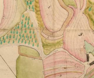
Deutsch: Flurkarte, um 1800 (Staatsarchiv Sigmaringen, Recherche F. Kanzler 2006). Ausschnitt: Gelände um die Heuneburg vor der Verebnung des Walles und mit der alten Wegeführung. |
| Date | circa 1800 |
| Source | [1] |
| Author | Unknown author |
|
This work is in the public domain in its country of origin and other countries and areas where the copyright term is the author's life plus 100 years or fewer. | |
| This file has been identified as being free of known restrictions under copyright law, including all related and neighboring rights. | |
File history
Click on a date/time to view the file as it appeared at that time.
| Date/Time | Thumbnail | Dimensions | User | Comment | |
|---|---|---|---|---|---|
| current | 15:58, 29 December 2010 | | 320 × 267 (14 KB) | AndreasPraefcke (talk | contribs) | {{Information |Description=Flurkarte, um 1800 (Staatsarchiv Sigmaringen, Recherche F. Kanzler 2006). Ausschnitt: Gelände um die Heuneburg vor der Verebnung des Walles und mit der alten Wegeführung. |Source=http://www.fuerstensitze.de/1076_Laufende-Arbe |
You cannot overwrite this file.
File usage on Commons
There are no pages that use this file.
File usage on other wikis
The following other wikis use this file:
- Usage on de.wikipedia.org