File:France Rivers of Gers.svg
Jump to navigation
Jump to search

Size of this PNG preview of this SVG file: 625 × 557 pixels. Other resolutions: 269 × 240 pixels | 539 × 480 pixels | 862 × 768 pixels | 1,149 × 1,024 pixels | 2,298 × 2,048 pixels.
Original file (SVG file, nominally 625 × 557 pixels, file size: 888 KB)
Captions
Captions
Add a one-line explanation of what this file represents
| Description |
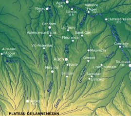
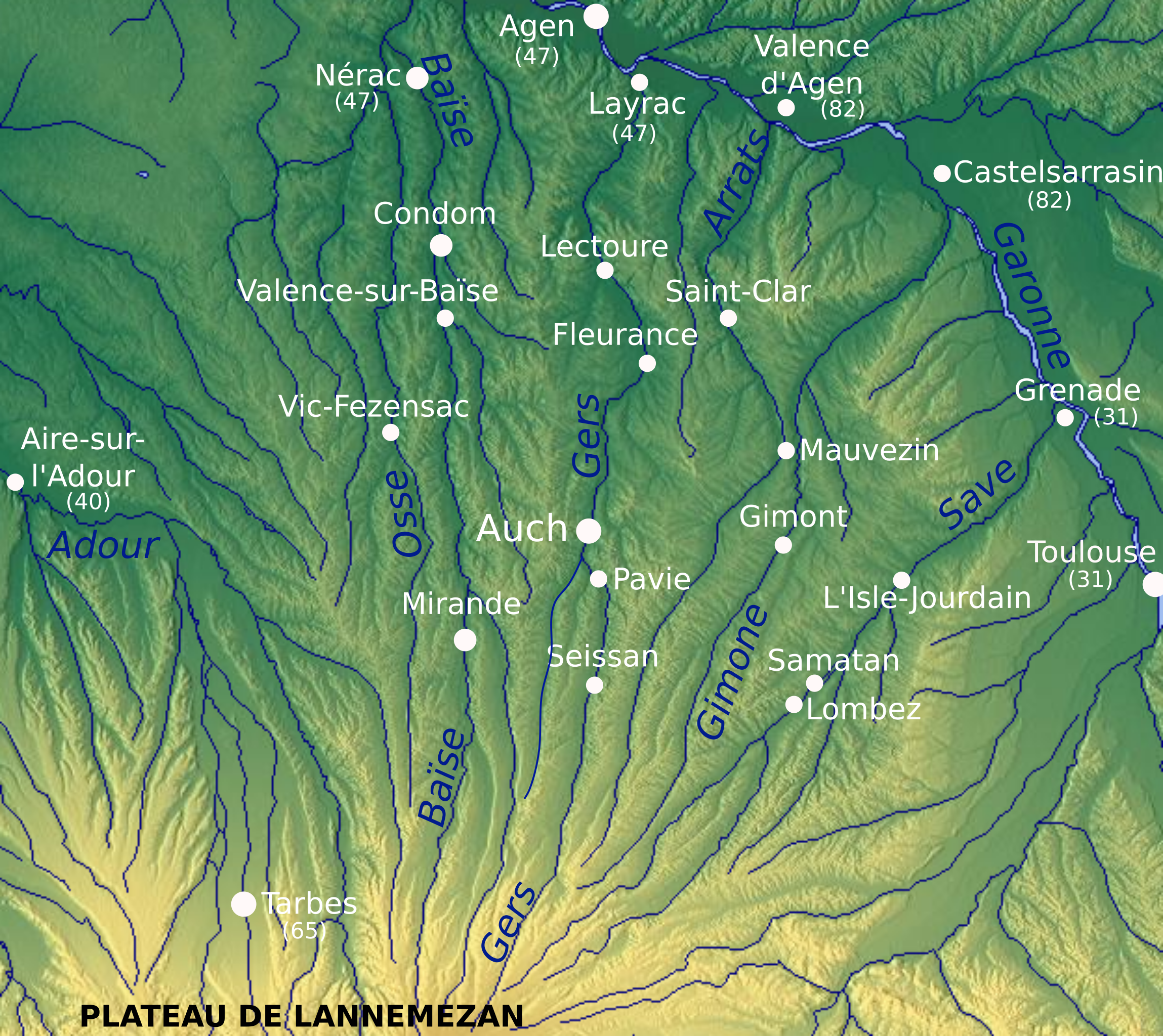
English: Rivers of the French departement Gers, with river names and town of source and confluence Français : Chevelu des rivières du Gers, avec noms et communes de source et de confluence |
| Date | (UTC) |
| Source |
|
| Author |
|
| Other versions | Derivative works of this file: France Rivers of Gers with 1977 inundation effects.svg |
I, the copyright holder of this work, hereby publish it under the following licenses:

|
Permission is granted to copy, distribute and/or modify this document under the terms of the GNU Free Documentation License, Version 1.2 or any later version published by the Free Software Foundation; with no Invariant Sections, no Front-Cover Texts, and no Back-Cover Texts. A copy of the license is included in the section entitled GNU Free Documentation License. |
This file is licensed under the Creative Commons Attribution-Share Alike 3.0 Unported license.
- You are free:
- to share – to copy, distribute and transmit the work
- to remix – to adapt the work
- Under the following conditions:
- attribution – You must give appropriate credit, provide a link to the license, and indicate if changes were made. You may do so in any reasonable manner, but not in any way that suggests the licensor endorses you or your use.
- share alike – If you remix, transform, or build upon the material, you must distribute your contributions under the same or compatible license as the original.
You may select the license of your choice.
Original upload log[edit]
This image is a derivative work of the following images:
- File:Rivières_gersoises.png licensed with Cc-by-sa-3.0
- 2010-03-13T11:00:20Z Cordelialear 625x557 (644098 Bytes) Minuscule fix to make northern Cyprus be coloured when Cyprus is coloured and Northern Cyprus isn\'t explicitly so.minor fixminor fixminor fixminor fixminor fixminor fixminor fixminor fixminor fixminor fixminor fixminor fix
Uploaded with derivativeFX
File history
Click on a date/time to view the file as it appeared at that time.
| Date/Time | Thumbnail | Dimensions | User | Comment | |
|---|---|---|---|---|---|
| current | 17:12, 21 March 2010 | | 625 × 557 (888 KB) | Pethrus (talk | contribs) | Minor corrections |
| 13:46, 17 March 2010 |  | 625 × 557 (888 KB) | Pethrus (talk | contribs) | Removed/added towns and rivers | |
| 23:12, 16 March 2010 |  | 625 × 557 (881 KB) | Pethrus (talk | contribs) | Uncluttering the map | |
| 11:29, 16 March 2010 |  | 625 × 557 (885 KB) | Pethrus (talk | contribs) | {{Information |Description={{en|1=Rivers of the French ''departement'' Gers, with river names and town of source and confluence}}{{fr|1=Chevelu des rivières du Gers, avec noms et communes de source et de confluence}} |Source=*[[:File:Rivières_gersoises. |
You cannot overwrite this file.
File usage on Commons
The following page uses this file:
File usage on other wikis
The following other wikis use this file:
- Usage on fr.wikipedia.org
- Usage on it.wikipedia.org
- Usage on ru.wikipedia.org