File:Mapa de la frontera México-Guatemala (1866 mexicana).svg
(Redirected from File:Frontera prop Mex a Guat Cubas.svg)

Size of this PNG preview of this SVG file: 800 × 599 pixels. Other resolutions: 320 × 240 pixels | 640 × 480 pixels | 1,024 × 767 pixels | 1,280 × 959 pixels | 2,560 × 1,918 pixels | 1,089 × 816 pixels.
Original file (SVG file, nominally 1,089 × 816 pixels, file size: 194 KB)
Captions
Captions
Add a one-line explanation of what this file represents
Summary[edit]
.svg&action=edit§ion=1)
| Description |
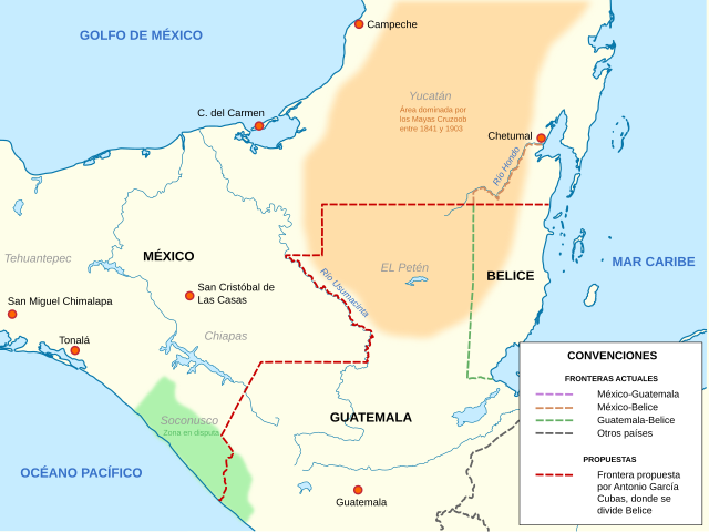
English: Mexico's border proposal for the resolution of borders with Guatemala in 1866.
Based on: McGogam , Gerald L.; Geografía histórica política de la Reforma;1991; México: Colegio Mexiquense e INEGI; INSB 968-6341-16-1;
Español: Frontera propuesta por México para la resolución de los límites fronterizos con Guatemala en 1866.
Basado en. McGogam , Gerald L.; Geografía histórica política de la Reforma;1991; México: Colegio Mexiquense e INEGI; INSB 968-6341-16-1; |
| Source | Own work |
| Author | Sarumo74 |
Licensing[edit]
.svg&action=edit§ion=2)
I, the copyright holder of this work, hereby publish it under the following licenses:

|
Permission is granted to copy, distribute and/or modify this document under the terms of the GNU Free Documentation License, Version 1.2 or any later version published by the Free Software Foundation; with no Invariant Sections, no Front-Cover Texts, and no Back-Cover Texts. A copy of the license is included in the section entitled GNU Free Documentation License. |
This file is licensed under the Creative Commons Attribution 3.0 Unported license.
- You are free:
- to share – to copy, distribute and transmit the work
- to remix – to adapt the work
- Under the following conditions:
- attribution – You must give appropriate credit, provide a link to the license, and indicate if changes were made. You may do so in any reasonable manner, but not in any way that suggests the licensor endorses you or your use.
You may select the license of your choice.
File history
Click on a date/time to view the file as it appeared at that time.
| Date/Time | Thumbnail | Dimensions | User | Comment | |
|---|---|---|---|---|---|
| current | 01:22, 9 January 2018 | | 1,089 × 816 (194 KB) | Milenioscuro (talk | contribs) | corrijo error en las convenciones |
| 07:45, 8 January 2018 |  | 1,089 × 816 (198 KB) | Milenioscuro (talk | contribs) | mejoras del mapa, colores según convenciones | |
| 01:18, 22 March 2011 |  | 1,343 × 1,183 (51 KB) | Sarumo74 (talk | contribs) | {{Information |Description ={{en|1=Mexican´s border proposal for the resolution of borders with Guatemala in 1866. Based on: McGogam , Gerald L.; Geografía histórica política de la Reforma;1991; México: Colegio Mexiquense e INEGI; INSB 968-6341- |
You cannot overwrite this file.
File usage on Commons
The following page uses this file:
- File:Frontera prop Mex a Guat Cubas.svg (file redirect)
File usage on other wikis
The following other wikis use this file:
- Usage on es.wikipedia.org
.svg&oldid=489488777)